1. Förbättra skogens motståndskraft och anpassning till klimatförändringar

Engelska
Innovasion
Yes
E-postadress för ägaren eller författaren
Voting
0%
Startår
2019
Titel (förkortning)
UFP
Kort beskrivning
Combining the capabilities of the Geoportal "Forests of Ukraine" and the mobile application UFP for collecting data in the forest on the outbreaks of pests or diseases and its diagnostics and monitoring. App aimed at professional foresters.
Digital lösning
Yes
Sammandrag

Mobile app Ukrainian Forest Protection for smartphones based on Android OS.

The app uses mobile devices for collection of data about pests and diseases. It has several levels of use:

  • at first forestry specialists collect data about discovered cases
  • this data is synchronized at all mobile devices of the enterprise and enters the database of "Forests of Ukraine" Geoportal
  • furthermore, other forest specialists can review the information about the pest and disease cases, discovered in the forest enterprise
  • if needed, the damaged area can be found in the field using the built-in GPS receiver, then verified or deleted. 

For the diagnostics of the damaged area, the built-in digital handbook can be used, which includes information about all pests and diseases found in the forests of Ukraine, structured with the visual materials, data on diagnostic features and protection/management measures.

After introduction of any of changes in the app, all the information become accessible at the "Forests of Ukraine" Geoportal, which allows to:

  • print out reports for the enterprise level and regional level,
  • review of identified and verified cases on the map,
  • see the dynamics by pest and disease types, by the time,
  • define and identify the location, distribution features and development of pathological processes in the forests of Ukraine.
Ägare eller författarorganisation
URIFFM
Namn på ägaren eller författaren
Prof. Viktor Tkach
Rapportör
FORZA NGO
Namn på rapportören
Lesya Loyko
E-post till rapportören
Titel resurs 1
Video review of selected possibilities of the system
Huvudbild
Ytterligare bild 1
Ytterligare bild 2
BP - Rosewood - V1
NO
Upphovsland
Ukraina
Titel (nationellt namn)
Лісозахист
Potential
Har video
no
Ukrainska
Innovasion
Yes
E-postadress för ägaren eller författaren
Voting
0%
Startår
2019
Titel (förkortning)
UFP
Kort beskrivning
Поєднання можливостей Геопорталу "Ліси України" та мобільного додатку UFP для збору даних в лісі про появу шкідників або хвороб, їх діагностики та моніторингу. На даному етапі – для фахівців лісового господарства.
Digital lösning
Yes
Sammandrag

Мобільний додаток Лісозахист для смартфонів на базі операційної системи Android.

Даний додаток передбачає використання мобільних пристроїв для збору інформації в лісі про появу шкідників або хвороб та має декілька рівнів можливостей: на першому етапі майстри лісу збирають дані про виявлені явища, ця інформація синхронізуються на всіх мобільних пристроях підприємства та потрапляє в базу Геопорталу "Ліси України". Далі фахівці підприємства (помічники лісничих, лісничі, інженери) мають змогу переглядати інформацію про виявлені осередки в усьому лісгоспі. За необхідності, можна знайти осередок на місцевості за допомогою вбудованого у смартфон GPS-приймача, підтвердити його або видалити.

Для діагностики осередку можна скористатися вбудованим електронним визначником, де зібрана інформація про всі хвороби та шкідники, притаманні лісам України. Визначник структурований, складається з наочних матеріалів і даних про діагностичні ознаки та заходи боротьби.

Після виконання будь-яких змін в додатку, вся інформація буде доступна на Геопорталі «Ліси України», де було розроблено декілька сторінок націлених на роботу з електронною базою осередків, а саме:

  • друк звітності підприємств та ОУЛМГ,
  • перегляд виявлених та підтверджених осередків на карті,
  • відображення динаміки осередків в розрізі видів шкідників та хвороб, місяців,
  • виявлення та визначення локації осередків, закономірностей поширення та розвитку патологічних процесів у лісах України.
Ägare eller författarorganisation
УКРАЇНСЬКИЙ НАУКОВО-ДОСЛІДНИЙ ІНСТИТУТ ЛІСОВОГО ГОСПОДАРСТВА ТА АГРОЛІСОМЕЛІОРАЦІЇ ІМ. Г.М. ВИСОЦЬКОГО
Namn på ägaren eller författaren
ТКАЧ ВІКТОР ПЕТРОВИЧ
Rapportör
ГО ФОРЗА
Namn på rapportören
Леся Лойко
E-post till rapportören
Titel resurs 1
Відеоогляд окремих можливостей системи
Huvudbild
Ytterligare bild 1
Ytterligare bild 2
BP - Rosewood - V1
NO
Upphovsland
Ukraina
Titel (nationellt namn)
Лісозахист
Potential
Har video
no
Engelska
Innovasion
Yes
E-postadress för ägaren eller författaren
Voting
0%
Startår
2014
Slutår
2022
Kort beskrivning
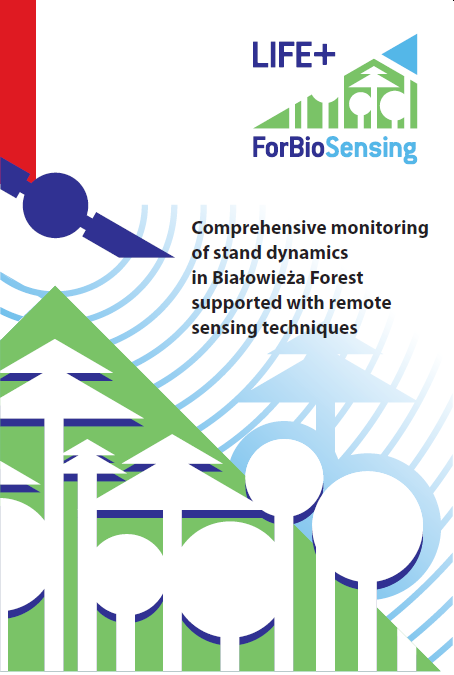
Comprehensive monitoring method of a large forest area with the use of innovative techniques and data.
Digital lösning
Yes
Sammandrag

Project activities were focused on a comprehensive representation of changes in forest stands and their dynamics (using different time series of remote sensing data) and the transition from spot monitoring (field measurements on sample plots) to large-scale monitoring. This will improve the efficiency of forest ecosystem protection and management measures. Project results have been presented in the form of publications and maps showing specific changes over the years. In addition, radio and television broadcasts, meetings, brochures and promotional films were used to inform the general public.

The main objectives of the project were:

  • Monitoring of stand dynamics in Białowieża Forest (including analysis of tree species composition, monitoring of changes in the forest stand caused, among others, by tree death)
  • Analysis of natural forest regeneration and rejuvenation, including the role of gaps,
  • Establishment/determination of the combination of different remote sensing techniques and data sets that are optimal for forest monitoring,
  • Characteristics of the microclimate of the Białowieża Forest,
  • Promotion of Białowieża Forest through the use of multimedia.

The main expected results of the project:

  • Detailed analysis and maps showing in subsequent years, following information about the Białowieża Forest: Forest stand characteristics (growing stock and biomass, tree height, DBH, canopy cover and its diversity, forest diversity, tree species composition, vertical structure, biomass, etc.), location and size of dead trees, location and size of gaps, dynamics of natural forest regeneration and amount of lying dead wood.
  • Map of plant communities with identification of different tree species;
  • Development of monitoring methods for the dynamics of the Białowieża Forest using a small number of sample plots and additional remote sensing data covering the entire study area;
  • Master tree ring chronology of the selected tree species in the Białowieża Forest;
  • A unique geoportal containing created spatial data on the Białowieża Forest.
Ägare eller författarorganisation
Instytut Badawczy Leśnictwa
Namn på ägaren eller författaren
Krzysztof Stereńczak
Rapportör
Łukasiewicz Research Network - Wood Technology Institute
Namn på rapportören
Dobrochna Augustyniak-Wysocka
Projektreferens
ForBioSensing project is co-funded by the European Commission under European Union financial instrument LIFE+ and by the National Fund for Environmental Protection and Water Management
Titel resurs 1
Stereńczak K., Mielcarek M., Modzelewska A., Kraszawski B., Fassnacht F.E., Hilszczański J. 2019. Intra-annual Ips typographus outbreak monitoring using a multi-temporal GIS analysis based on hyperspectral and ALS data in the Białowieża Forests. Forest Ecology and Management, 442: 105–116.
Titel resurs 2
Project leaflet [PL, EN]
Dokumentation resurs 2
Huvudbild
Logo för best practice
Logo, huvudorganisation
Projektlogo
Nav
Central-East Hub
BP - Rosewood - V1
NO
Upphovsland
Polen
Titel (nationellt namn)
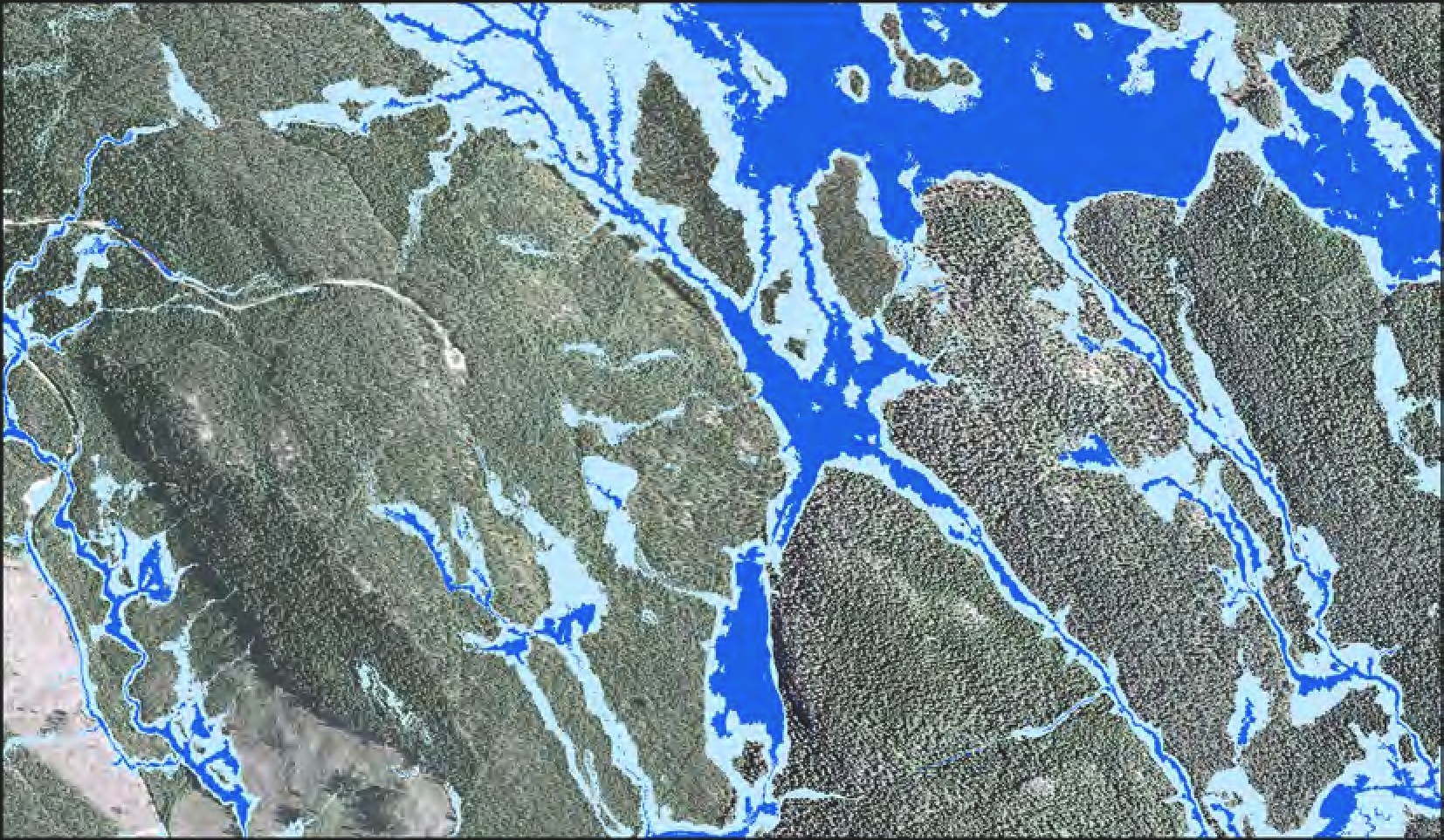
Kompleksowy monitoring dynamiki drzewostanów Puszczy Białowieskiej
Potential
Projekt som detta factsheet skapats inom
Har video
yes
Engelska
Innovasion
Yes
E-postadress för ägaren eller författaren
Voting
0%
Startår
2016
Slutår
2019
Kort beskrivning
The aim of the WAMBAF and WAMBAF ToolBox projects was to determine the methods and tools of water management in forests, which would influence the quality of water flowing into the Balitc Sea.
Digital lösning
Yes
Sammandrag

The scope of the projects included issues related to:

  • operation and maintenance of drainage equipment,
  • the beaver's impact on water quality,
  • forest management in the vicinity of surface waters,
  • modern tools supporting water management in forests.

Among the main practical results of the projects there are: 

- Mobile apps:

  • WAMBAF (available on Android and iOS), developed to support the ditch inventorying and ditch management in forests. Application is connected to the GIS system available on: http://www.wambaf.com/?page_id=154&lang=en,
  • Blue Targeting (available on Android and iOS), a forestry planning tool which helps you design a riparian forest buffer. The aim is to protect water quality and biodiversity by proposing the right measure, at the right place, to the right extent.

- Wet Area Maps – available for Sweden, Poland, Finland and Latvia, based on airborne laser scanning data. Maps illustrate the occurence of groundwater and may be used in the planning of wood harvesting operations.

- Developing the algorithm for drainage ditches detection basing on airborne laser scanning data. It will be published as open source in 2022.

In the projects several Good Practice Manuals have been developed, regarding: water management in riparian forests, structures for water retention in forests and beaver population management. The manuals are available in several language versions. Main target groups were: forest managers, harvesting machines' operators, land owners, hunters and nature conservation units. The coordinator of the projects was Swedish Forest Agency (Skogsstyrelsen).


Ägare eller författarorganisation
Instytut Badawczy Leśnictwa
Namn på ägaren eller författaren
Mariusz Ciesielski
Rapportör
Łukasiewicz Research Network - Wood Technology Institute (ITD)
Namn på rapportören
Dobrochna Augustyniak-Wysocka
Projektreferens
Water Management in Baltic Forests, projekt co-financed by European regional Development Fund, Interreg Baltic Sea Region
Titel resurs 1
Good practices for management of beavers and beaver ponds in the Baltic Sea Region
Titel resurs 2
Manual for constructing water protection structures at ditch network maintenance sites and for water retention in forests
Huvudbild
Huvudbildens bildtext
Wet Area Map (in dark blue: areas with occurence of groundwater ranging from 0 to 0.5 m)
Logo för best practice
Ytterligare bild 1
Ytterligare bild 2
Nav
Central-East Hub
BP - Rosewood - V1
NO
Upphovsland
Finland
Lettland
Litauen
Polen
Ryssland
Sverige
Titel (nationellt namn)
[PL] Gospodarowanie wodą w lasach nadbałtyckich
Projekt som detta factsheet skapats inom
Har video
no
Tyska
Innovasion
Yes
E-postadress för ägaren eller författaren
Id: 2861876
Continent Code: EU
Country Code: DE
Country Name: Germany
Name: North Rhine-Westphalia
Voting
0%
Startår
2019
Kort beskrivning
KI-gestütztes Sensorsystem zur dauerhaften Überwachung von Umweltparametern in Waldbeständen
Digital lösning
Yes
Sammandrag

Mit Aja hat das Start-up-Unternehmen foldAI eine Lösung für das Monitoring des Waldzustands entwickelt, die eine konkrete Entscheidungsunterstützung für die Durchführung forstlicher Maßnahmen liefert und gleichzeitig ein umfassendes Verständnis der Waldökosysteme ermöglicht. Durch den Einsatz von modernstem maschinellem Lernen auf der Grundlage präziser Sensordaten in Echtzeit erlaubt Aja nicht nur, Waldbedrohungen sehr früh zu erkennen, sondern ihre Entstehung vorherzusagen und den weiteren Verlauf zu prognostizieren. Aja verbessert die Gesundheit, die Widerstandsfähigkeit und die bioökonomische Leistung der Wälder, indem es schlanke Prozesse für ein Ökosystemmanagement auf breiter Basis ermöglicht. Waldbewirtschaftung wird durch eine vollautomatische, hochauflösende und erschwingliche Lösung für mehr als 30 Millionen Waldbesitzer in Europa, Russland und Nordamerika unterstützt.  Aja basiert auf eingebettetem maschinellem Lernen und biochemischer und ökologischer Signalverarbeitung auf hochdimensionalen Daten. Anwendungsszenarien sind etwa die Bewertung von Umweltauswirkungen, die eine genauere Abschätzung der Umweltfolgen einer Strategie oder Politik ermöglicht, aber auch die Risikobewertung und Warnung vor akuten Bedrohungen. Darüber hinaus erlaubt die Lösung auch die Messung der biologischen Vielfalt und des Zustands von Ökosystemen. Die signifikante Auswirkung von Aja auf die Kohlenstoffreduzierung wurde von unabhängiger Seite durch The Climate Impact Forecast zertifiziert.


Ägare eller författarorganisation
foldAI
Namn på ägaren eller författaren
Dr. Friedrich Förster
Rapportör
Forstliches Bildungszentrum NRW
Namn på rapportören
Dr. Marie-Charlotte Hoffmann
Huvudbild
Logo för best practice
Ytterligare bild 1
Upphovsregion
2861876
BP - Rosewood - V1
NO
Upphovsland
Tyskland
Projekt som detta factsheet skapats inom
Rosewood Video
Har video
yes
Engelska
Innovasion
Yes
E-postadress för ägaren eller författaren
Hållbarhets potential
Sustainable forest management is strongly supported by real time data on the forest's health status
Påverkan på miljö & biologisk mångfald

The solution helps to monitor ecosystem functions of forests and biodiversity, thereby improving risk management 

Id: 2861876
Continent Code: EU
Country Code: DE
Country Name: Germany
Name: North Rhine-Westphalia
Voting
0%
Startår
2019
Kort beskrivning
Forest health solution built upon an innovative sensor technology for real-time ecosystem monitoring
Digital lösning
Yes
Sammandrag

The startup foldAI has developed sensors to screen health status of forests providing forest managers with a rich understanding of their forest ecosystems, and a decision toolbox to deploy immediate mitigating actions. The team’s solution, Aja, used in the sensors is  a framework for ecosystem management based on deep technology. By harnessing state-of-art Machine Learning on precise, real-time sensor data, Aja can not only detect forest threats as they happen, but even predict their arising and forecast their unfolding. Aja improves forest health, resilience and bioeconomical performance by introducing lean processes to a broad ecosystem management community. It helps reducing greenhouse emissions by scaling high resolution forest management through a fully automated and affordable solution for more than 30 Million forest owners in Europe, Russia and North America. The solution builds on embedded Machine Learning, and biochemical and environmental signal processing on high-dimensional data. Use cases comprise the assessment of environmental impacts enabling greater accuracy in the evaluation of the environmental consequences of a strategy or policy, risks assessment including alerts to threats, biodiversity quantification and ecosystem health tracking. Aja’s significant carbon reduction impact has been independently certified by The Climate Impact Forecast.

Ägare eller författarorganisation
foldAI
Namn på ägaren eller författaren
Dr. Friedrich Förster
Namn på rapportören
Dr. Marie-Charlotte Hoffmann
Huvudbild
Logo för best practice
Ytterligare bild 1
Upphovsregion
2861876
BP - Rosewood - V1
NO
Hållbarhets potential - Värde
Very Positive
Upphovsland
Tyskland
Projekt som detta factsheet skapats inom
Rosewood Video
Har video
yes
Engelska
Innovasion
No
E-postadress för ägaren eller författaren
Voting
0%
Startår
2019
Kort beskrivning
Think Woods purpose is to show how forests and trees can contribute in the fight against climate changes.
Digital lösning
No
Sammandrag

Never has the world had greater need for sustainable solutions. Think wood is an industry initiative from several companies and organizations within the Norwegian forest and wood industry. Together, we want to show how forests and trees can contribute in the fight against climate changes. Since its inception in 2019, the project has developed a number of articles and films, which easily and engagingly show what kind of products can be made of wood. Everything that is currently made of oil can in principle also be made of wood – and that with far lower emissions. The overall goal of the initiative is to show people why forests and wood are an important part of the climate solution. If we are going to achieve the UN’s sustainable climate goals, consumers, businesses, and politicians must actively choose renewable resources, such as wood, over non-renewable resources like petroleum and coal. Wood is the future. Not only as a resource, but as a green job creator all over Norway.

Ägare eller författarorganisation
www.tenktre.no/
Namn på ägaren eller författaren
Øyvind Wang
Rapportör
Tretorget Ltd
Namn på rapportören
Ola Rostad
E-post till rapportören
Titel resurs 1
Video
Huvudbild
Logo för best practice
Enkel implementering - Utvärdering
Medium
Nav
Northern Hub
BP - Rosewood - V1
NO
Hållbarhets potential - Värde
Positive
Upphovsland
Norge
Titel (nationellt namn)
Tenk Tre
Potential
Projekt som detta factsheet skapats inom
Har video
no
Engelska
Innovasion
Yes
E-postadress för ägaren eller författaren
Typ av trä
Reforestation and creation of forest areas
Hållbarhets potential
Allows for better management of forests, and ensures the success of new plantations
Påverkan på miljö & biologisk mångfald

SISREP enables better forest management and ensures the success of new tree plantations, thus improving the preservation of the environment and the creation of new forest ecosystems.

Therefore, the project has a very positive impact on the environment and biodiversity. 

Ekonomisk effekt
Very positive. Better forest management can generate more income.
Specifika kunskapsbehov
Use of digital tools.
Nyckel förutsättningar

In order to carry out this project, it would be necessary to have a solid database, compiled over a number of years.

Voting
0%
Kort beskrivning
SISREP is a project that has developed an advanced statistical model that allows predictive and descriptive analyses to be carried out using a forestation survival prediction tool to ensure the success of new plantations. SISREP is based on the use of knowledge from historical in-situ visits to predict the probability of success of future plantations using machine learning techniques, and on a database with more than 50,000 observations referring to forestations carried out from 1993 to the present day.
Digital lösning
Yes
Vedens ursprung
Trätyp
kommersiell potential

Very positive, as SISREP is a support system for forest management in multiple variants, as well as a valuable aid to both private owners and managers in the task of creating new forests and, in the medium term, managing specific aspects of existing ones.

The use of data derived from the daily management of administrations is a highly valuable source of information that can help to improve the services offered by these administrations. To this end, the digitisation of processes becomes a fundamental and indispensable task. 

Sammandrag

The main objective of SISREP is to make use of the information obtained during inspections in the framework of aid for afforestation and the creation of forest areas in Castilla y León in order to:

  • Use of the information obtained in the field for the management of the controlled files.
  • Creation of a centralised and geo-referenced database with information on the state of plantations.
  • To be able to predict, by means of artificial intelligence techniques, the success of future plantations.
  • With the knowledge extracted, review and improve the planning of future actions, allowing the implementation of the most appropriate technical conditions for the new environmental circumstances.

To this end, an infrastructure has been designed and implemented that allows the digitalisation of the entire workflow, from data collection in the field to the use of these data in advanced statistical analysis tools.

The data collected in the field are for example species, altitude, density, slope, method, orientation, age, lithography, with or without sowing, or area.

Ägare eller författarorganisation
CESEFOR, Junta de Castilla y León
Namn på ägaren eller författaren
Francisco Gallego
Rapportör
Fundación CESEFOR
Namn på rapportören
Angela García de Arana
E-post till rapportören
Titel resurs 1
Presentación : Proyecto SISREP
Huvudbild
Nav
South-Western Hub
BP - Rosewood - V1
NO
Hållbarhets potential - Värde
Very Positive
Upphovsland
Spanien
Titel (nationellt namn)
SISREP | Gestión y análisis de reforestaciones en tierras agrarias
Projekt som detta factsheet skapats inom
Har video
no
Engelska
Innovasion
Yes
E-postadress för ägaren eller författaren
Voting
0%
Kort beskrivning
PONSEE is introducing firefighting equipment to be installed in the load spaces of forwarders for extinguishing wildfires.
Digital lösning
No
Sammandrag

Forest machine is the most natural and effective way to access a forest fire area. Operations in difficult terrain come as second nature to them, and they have more than enough capacity in their hydraulic system for demanding conditions. The firefighting equipment is delivered to the fire location as a single package – and after it has been connected to forest machine hydraulics, the equipment is ready to operate.

The 10 m³ water tank of the firefighting equipment can be filled with its own pump from a natural water source or the tank of a fire truck. The water cannon has a range of 47 metres and a turning radius of 360 degrees. It takes 5 to 10 minutes to refill the tank. The filling hose is guided by the forwarder's boom and the strainer on the tank roof takes out the biggest debris. The water cannon is controlled with the remote control. The system draws its power from the hydraulics of the forwarder.

Ägare eller författarorganisation
Ponsse
Namn på ägaren eller författaren
Juha Harverinen
Huvudbild
Logo för best practice
Ytterligare bild 1
BP - Rosewood - V1
NO
Upphovsland
Finland
Titel (nationellt namn)
PONSSE palotorjuntakalusto kuormatraktoriin
Projekt som detta factsheet skapats inom
Har video
yes
Engelska
Innovasion
Yes
E-postadress för ägaren eller författaren
Voting
0%
Startår
2009
Kort beskrivning
A full-scale system supporting the organisation of work and resource planning in national parks, municipal and communal forests and experimental forestry units, covering day-to-day management in a given unit and specific tasks arising from the needs of nature conservation.
Digital lösning
Yes
Sammandrag

The LasInfo system is a comprehensive product consisting of several interlinked applications. It is targeted at national parks, municipal and communal forests and experimental forestry units. It provides support for forest land management and monitoring of timber harvest and sales, as well as for the implementation of tasks specified in the protection plan and nature monitoring.

The solution consists of four basic modules: the central database, the LasInfo Client application, the GIS application and the Forester’s Electronic Logbook. This allows for coordinated management of elements such as nature conservation, forest management, spatial data and cadastral data. It is possible to tailor the solution to individual users by implementing only some or all elements of the system. The shared database in turn eliminates the problem of incompatibility between different systems and data formats.

Components of the LasInfo system:

  • Software: centralized database, LasInfo application, LasInfo Timber Trade application, Digital Map, Nature Monitoring, Mobile GIS.
  • Devices/infrastructure: server (local or "in the cloud"), network and VPN devices, mobile devices.

Functionalities of the Lasinfo system:

  • property records: cadastral records, forest inventory data;
  • planning (protection tasks) system: stock surveys, creation of planning items, handling of invitations to tender, register of execution (work orders, work acceptance);
  • timber sales: documentation on incoming and outgoing timber, timber contracts, timber stock, forester's logbook;
  • Forest protection and silviculture documents: dead wood inventory, fire registry, regeneration assessment report, natural regeneration assessment report;
  • reporting of: planned works, timber sales, work orders/executions;
  • numerical map: the Digital Forest Map standard, the GIS data standard in nature conservation, nature monitoring, map reporting, mobile GIS.

The system has been rolled out in 11 Polish national parks; moreover, among the LasInfo users are forestry experimental units (Murowana Goślina, Siemianice, Rogów, Krynica-Zdrój), municipal and communal forest managers and maritime offices managing forest areas.

Ägare eller författarorganisation
Taxus IT Sp. z o.o.
Namn på ägaren eller författaren
Sylwester Kulik
Rapportör
Łukasiewicz Research Network - Wood Technology Institute (ITD)
Namn på rapportören
Dobrochna Augustyniak-Wysocka
Huvudbild
Logo, huvudorganisation
Nav
Central-East Hub
BP - Rosewood - V1
NO
Upphovsland
Polen
Titel (nationellt namn)
Zintegrowany system informatyczny dla parków narodowych, ochrony przyrody i leśnictwa
Potential
Projekt som detta factsheet skapats inom
Har video
no