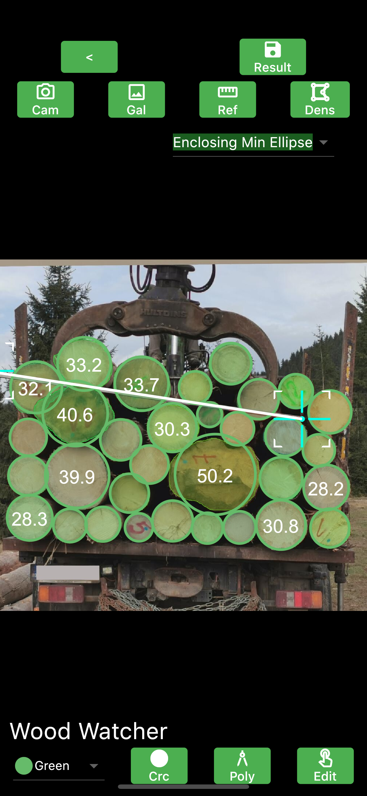
Sensors, measurement equipment

Slovak
Innovation
Yes
Owner or author e-mail
Country Region City
Finland
Voting
0%
Start Year
2012
Short description
TRESTIMA® je nová a inovatívna technológia pre inventarizáciu lesov. Les sa meria fotením pomocou mobilnej aplikácie. Automaticky rozpozná druh strom a vypočítava premenné lesa, napr. bazálna plocha, počet kmeňov, výška, objem.
Digital solution
Yes
Abstract

TRESTIMA® Forest Inventory System dodáva meraniu lesa presnosť, rýchlosť, flexibilitu a objektivitu. Môžete ukladať rôzne typy údajov označených GPS v lese a neskôr si svoje nahrávky prezerať pomocou počítača alebo mobilného zariadenia. Používanie TRESTIMA® je jednoduché. Vydajte sa na prechádzku do lesa a zároveň tvorte presné meranie lesa fotografovaním pomocou aplikácie v mobilnom telefóne. Pred prechodom na stránku môžete nahrať alebo nakresliť časti lesa, na ktorom môžete na obrazovke vidieť svoju vlastnú pozíciu a hranice. Vďaka tomu je navigácia jednoduchá a stačí, ak budete fotografovať rovnomerne počas chôdze. Meranie lesov je jednoduché, efektívne, objektívne a dokonca zábavné! Meranie jedného hektára lesa trvá v priemere menej ako 5 minút.

TRESTIMA® ponúka služby pre rôznych užívateľov. Správcovia lesov môžu zbierať údaje o lesoch fotografovaním a vkladaním pomocou navrhnutej mobilnej aplikácie. Vlastníci lesov sú schopní merať hodnotu svojho lesa s aplikáciou TRESTIMA®. Kupujúci dreva môžu merať les tak, aby bol rýchlo vyrúbaný s ľahkosťou vytvoríte ad hoc ponuku a realitní makléri urobia podrobný a presný odhad hodnoty nehnuteľnosti a jednoducho ju zdieľajú v digitálnom formáte. Vládny úradníci môžu zaznamenávať údaje označené GPS a merať rastúce drevo. Okrem toho môžu brány a terminály merať hromady dreva a celulózy rýchlo a presne s aplikáciou TRESTIMA® Stack.

Owner or author organization
Trestima Ltd.
Owner or Author name
Simo Kivimäki, CEO
Reporter organisation
Natural Resources Institute Finland (Luke)
Reporter name
Kari Mäkitalo
Reporter e-mail
Main picture
Main picture caption
Measure forest and roundwood piles fast and easily by taking pictures
Logo of Best Practice
Hub
Northern Hub
BP - Rosewood - V1
NO
Country of origin
Finland
Scale of application
Has video
yes
Slovak
Innovation
Yes
Owner or author e-mail
Voting
0%
Start Year
2013
Digital solution
Yes
Abstract

Špičková röntgenová technológia použitá na optimalizáciu efektívnosti zdrojov a pridanej hodnoty v pílach Goldeneye 300 Multi-Sensor Quality Scanner spoľahlivo rozpoznáva chyby dreva, vyberá podľa pevnostných tried a drevo presne klasifikuje. Výsledky optimalizácie podľa delenia a triedenia, reagujúce na požiadavky kvality. Multisenzorový kvalitný skener Goldeneye 300 pozostáva z modulov sfarebným, laserovým a röntgenovým lúčom na presnú klasifikáciu chýb dreva. Goldeneye 300 je spojený s orezávacou pílou a pokosovou pílou.

Owner or author organization
MICROTEC
Owner or Author name
Enrico Ursella
Reporter organisation
AIEL
Reporter name
Andrea Argnani
Reporter e-mail
Main picture
Logo of Best Practice
Additional visual 1
Additional visual 2
BP - Rosewood - V1
NO
Country of origin
Italy
Project under which this factsheet has been created
Rosewood Video
Watch video
Goldeneye presentation
Has video
yes
German
Innovation
Yes
Owner or author e-mail
Impact on environment & biodiversity

Wood Watcher trägt zu einer nachhaltigen und verantwortungsvollen Forstwirtschaft bei, indem es Automatisierung, Digitalisierung, Präzision, Vertrauen, Transparenz, Rückverfolgbarkeit und Objektivität fördert.


Ease of implementation
Wood Watcher ist jetzt zum Download für Android, iPhone und iPad verfügbar. Sie erhalten 10 kostenlose Credits und zahlen pro Messung, wenn Sie die Software nutzen.
Voting
0%
Start Year
2021
Title (abbreviation)
Wood Watcher
Short description
Wood Watcher bietet eine digitale Komplettlösung zur Messung von Holzpolter und Holztransporten mit Android-Handy, iPhone oder iPad.
Digital solution
Yes
Origin of wood
Type of wood
Abstract

Vorteil: Die manuelle Messung des Holzvolumens ist arbeitsintensiv und zeitaufwändig. Mit Wood Watcher kann das Holzvolumen  in wenigen Minuten digital auf dem Smartphone gemessen werden.

Einfacher Prozess:

  1. Richten Sie die Kamera Ihres Smartphones oder Tablets auf ein beliebiges Holzpolter oder einen Holzlaster und machen Sie ein Foto.
  2. Die Algorithmen der künstlichen Intelligenz analysieren jedes Pixel und erkennen alle Holzstämme (auch wenn sie teilweise verdeckt oder mit Schmutz oder Schnee bedeckt sind).
  3. Geben Sie die digitale Referenz und die Länge der Stämme ein.
  4. Sie erhalten sofort die Anzahl der Stämme, das Volumen in Kubikmetern, die Stapeldichte und die -kontur sowie einen detaillierten Bericht über jedes Holzstück.
  5. Speichern Sie die Messdaten in der Cloud und teilen Sie diese mit Ihren Geschäftspartnern.

Vorteile: 

1. Zeiteffizienz: Zeit ist der wichtigste Faktor in jedem Unternehmen. Die manuelle Vermessung eines Holzpolters oder eines Holztransportwagens dauert zwischen 30 und 120 Minuten. Mit Wood Watcher dauert es weniger als eine Minute.
2. Kosteneinsparungen: Manuelle Methoden erfordern den Einsatz mehrerer Arbeitskräfte - mindestens einen Kranführer und einen (oder zwei) Mitarbeiter, um 30-120 Minuten lang zu messen. Wood Watcher arbeitet mit nur einer Person (z.B. dem Kranführer) für eine Minute.
3. Sofortige Berichtserstellung: Keine manuelle Eingabe von Holzdurchmessern mit Stift und Papier oder die Dateneingabe mit Excel. Wood Watcher generiert sofort eine einfache .csv-Datei, eine .xlsx-Datei oder eine .pdf-Datei.
4. Reduzieren von Eingabefehlern: Wood Watcher minimiert menschliche Fehler bei der Dateneingabe.
5. Zufriedene und vertrauensvolle Kunden: Sowohl Verkäufer/Lieferanten als auch Käufer müssen in der Lage sein, die Angaben des jeweils anderen zu messen und zu überprüfen. Mit Wood Watcher wird objektiv gemessen und die Geschäftsbeziehung gestärkt.
6. Gemeinsame Nutzung von Daten. Prüfung der Einhaltung von Vorschriften. Bestandsübersicht in Echtzeit. Digitale Transformation. Die Verwendung bestehender, nicht skalierbarer Tools für die gemeinsame Nutzung von Daten ist in Ordnung, bis zu einem Punkt, an dem die Koordination des Informationsflusses zu einer Belastung wird. Mit Wood Watcher können Daten nahtlos zwischen Systemen ausgetauscht und in der Cloud gespeichert werden, so dass sie überall im Unternehmen leicht zugänglich und abrufbar sind.

Alle digitalen Daten können in das Wood Watcher Inventory System integriert werden oder das bestehende Inventar- und Verwaltungssystem des Unternehmens nutzen.

Einzelne Messdaten können durch zusätzliche Metadaten verbessert und an Geschäftsanforderungen und Best Practices angepasst werden: GPS, Quelle, Ziel, Transport-ID und mehr.

Owner or author organization
Wood Watcher
Owner or Author name
Razvan Pistolea
Title - Resource 1
Die Forstwirtschaft wandelt sich in Richtung Digitalisierung, Präzision und Automatisierung.
Title - Resource 2
App Store Download
Title - Resource 3
Google Play Download
Main picture
Main picture caption
Holzvolumen des Lastwagens; 2m Stahlstange als Referenz
Logo of Best Practice
Logo of Main Organization
Logo of Project
Additional visual 1
Additional visual 2
Additional visual 3
Ease of implementation - Evaluation
Very easy
BP - Rosewood - V1
NO
Sustainability Potential - Value
Very Positive
Country of origin
Germany
Canada
Poland
Romania
Austria
Title (national name)
Wood Watcher
Scale of application
Project under which this factsheet has been created
Rosewood Video
Watch video
Wood Watcher Smartphone Demo
Has video
yes
English
Innovation
Yes
Owner or author e-mail
Impact on environment & biodiversity

Wood Watcher contributes to sustainable and responsible forestry by promoting automation, digitalization, precision, confidence, transparency, traceability, objectivity.


Ease of implementation
Wood Watcher is available right now for download on Android, iPhone, and iPad. You get 10 free credits and you pay per measurement as you use the software.
Voting
0%
Start Year
2021
Title (abbreviation)
Wood Watcher
Short description
Wood Watcher offers a complete digital solution to measure wood piles and wood transports using an Android phone, iPhone or iPad.
Digital solution
Yes
Origin of wood
Type of wood
Abstract

Main benefit: Manual wood volume measuring is labour-intensive and time-consuming, however, volumes can be easily measured digitally in minutes on a smartphone using Wood Watcher.

Easy process:

  1. Point the camera from your phone or tablet to any wood stack or wood truck and take a picture
  2. The artificial intelligence algorithms analyze every pixel and detect all the wood logs (even partially obscured or dirt or snow-covered)
  3. Input the digital reference and the length of the logs
  4. Instantly receive the number of logs, the volume in cubic meters, the pile density and contour, and a detailed report of each piece of wood
  5. Save and share the measurement data to the cloud or with business partners


The benefits are: 

  1. Time efficiency. Time is the most important factor in any business. Manually measuring a woodpile or wood transport truck takes anywhere from 30 minutes to 120 minutes, but with Wood Watcher, it takes under 1 minute.
  2. Costs savings. Manual methods require significant manpower – at least a crane operator and one (or two) employees to measure for 30-120 minutes. Wood Watcher works with only 1 person (ex: the crane operator) for 1 minute.
  3. Instant report generation. Forget manually entering wood diameters using pen and paper or excel data input. Wood Watcher generates a basic .csv file or excel .xlsx file or .pdf file instantly.
  4. Reduce human input error. We are human and we make mistakes when measuring, when inputting data or when reporting data. When using Wood Watcher all human errors are minimized.
  5. Satisfied and confident customers. Both sellers/suppliers and buyers need to be able to measure and verify each other’s claims. With Wood Watcher volumes can be measured objectively as many times as needed and the measurement ba used as proof.
  6. Data sharing. Compliance audit. Real-time inventory overview. Digital Transformation. With Wood Watcher, data can be shared between systems and stored in the Cloud making it easily accessible and retrievable.


All digital data can be integrated with Wood Watcher Inventory System or using the company's existing inventory and management system.

Individual measurement data can be improved and customized to business needs and best practices with extra metadata: GPS, source, destination, transport id and more.

Wood Watcher provides automation, digitalization, precision, confidence, transparency, traceability, objectivity, and increases productivity when measuring wood.

Owner or author organization
Wood Watcher
Owner or Author name
Razvan Pistolea
Title - Resource 1
The forestry industry is changing towards digitalization, precision, and automation
Title - Resource 2
App Store Download
Title - Resource 3
Google Play Download
Main picture
Main picture caption
Wood volume of truck; 2m steel bar reference
Logo of Best Practice
Logo of Main Organization
Logo of Project
Additional visual 1
Additional visual 2
Additional visual 3
Ease of implementation - Evaluation
Very easy
BP - Rosewood - V1
NO
Sustainability Potential - Value
Very Positive
Country of origin
Austria
Canada
Germany
Poland
Romania
Title (national name)
Wood Watcher
Scale of application
Project under which this factsheet has been created
Rosewood Video
Watch video
Wood Watcher Smartphone Demo
Has video
yes
Spanish
Innovation
Yes
Owner or author e-mail
Country Region City
Finland
Voting
0%
Start Year
2012
Short description
TRESTIMA® es una tecnología nueva e innovadora para inventarios forestales. El bosque se mide tomando fotos con una aplicación móvil, reconoce automáticamente las especies de árboles y calcula las variables forestales, por ejemplo: el área basal, el recuento de pies, la altura y el volumen.
Digital solution
Yes
Abstract

El sistema de inventario forestal TRESTIMA® añade precisión, rapidez, flexibilidad y objetividad a la medición forestal. Puede almacenar diferentes tipos de datos marcados por GPS en el monte y revisar posteriormente sus grabaciones con un ordenador o dispositivo móvil. Utilizar TRESTIMA® es fácil, al dar un paseo por el bosque se crea una medición precisa del bosque haciendo fotos con la aplicación del teléfono móvil. Se pueden cargar o dibujar parcelas forestales antes de ir al monte, tras lo cual se puede ver la propia posición del usuario y los límites de las parcelas en la pantalla. Esto hace que la navegación sea fácil y que sólo haya que hacer fotos regularmente durante el paseo. La medición de los montes es fácil, eficaz, objetiva e incluso divertida. La medición de una hectárea de bosque lleva una media de menos de 5 minutos.

TRESTIMA® ofrece servicios para diferentes usuarios. Los gestores forestales pueden recopilar datos forestales tomando fotografías e introduciéndolos con la aplicación móvil diseñada para ello. También, los propietarios forestales pueden medir el valor de su monte con la aplicación TRESTIMA®. Los compradores de madera pueden medir el monte a talar de forma rápida y sencilla para hacer una oferta ad hoc, y los agentes inmobiliarios hacer una estimación detallada y precisa del valor de la parcela y compartirla en formato digital con facilidad. Los funcionarios públicos pueden registrar los datos marcados con GPS sobre el terreno y medir la madera en crecimiento. Además, las puertas de los aserraderos y las terminales pueden medir pilas de madera y madera para pulpa de forma rápida y precisa con la aplicación TRESTIMA® Stack.

Owner or author organization
Trestima Ltd.
Owner or Author name
Simo Kivimäki, CEO
Reporter organisation
Natural Resources Institute Finland (Luke)
Reporter name
Kari Mäkitalo
Reporter e-mail
Main picture
Main picture caption
Mediciones forestales y de madera en rollo de forma rápida y sencilla mediante la toma de fotografías
Logo of Best Practice
Hub
Northern Hub
BP - Rosewood - V1
NO
Country of origin
Finland
Scale of application
Has video
yes
Polish
Innovation
Yes
Owner or author e-mail
Voting
0%
Short description
<table border="0" cellpadding="0" cellspacing="0" style="width:551px;" width="551"> <tbody> <tr height="60"> <td height="60" style="height:60px;width:551px;">Rozwiązanie w obszarze leśnictwa precyzyjnego, umożliwiające wykrywanie drzew porażonych przez kornika na podstawie fotografii (RGB i wielospektralnych) z dronów, samolotów, helikopterów lub satelitów.</td> </tr> </tbody> </table>
Digital solution
Yes
Abstract

Obecnie identyfikowanie uszkodzeń wywołanych przez kornikowate opiera się w dużej mierze na fizycznych oględzinach drzewostanu. Tego rodzaju monitoring umożliwia stosunkowo łatwe wykrywanie uszkodzeń, kiedy są już one zaawansowane, natomiast trudniej jest wykryć ataki na wczesnym ich etapie.  W związku z tym podejmowano próby identyfikacji ataków kornika za pomocą satelitarnych map radarowych, które są dobrym wskaźnikiem potencjalnych uszkodzeń i można je traktować jako uzupełnienie precyzyjnej analizy oferowanej przez Arboair. Arboair Forest Mapper to usługa, która umożliwia analizę zdjęć za pomocą sztucznej inteligencji. Opracowany algorytm był trenowany przy wykorzystaniu próby ponad 200 000 drzew i sprawdzony przez leśników pod kątem merytorycznym.

Monitoruj swój las pod katem zagrożenia przez korniki w trzech prostych krokach:

  1. Zbieranie danych: możesz samodzielnie obsługiwać drona lub zwróć się do nas - skontaktujemy Cię z naszymi partnerami, którzy posiadają specjalistyczne kompetencje i uprawnienia w zakresie obsługi dronów lub dostarczają wysokiej jakosci zdjęcia satelitarne.
  2. Analiza: wykrywanie ataków kornika, identyfikacja i liczenie drzew, oznaczanie gatunków drzew, wykrywanie powalonych drzew.
  3. Wyniki: przeglądaj na portalu Arboair, prześlij wyniki na własną platformę, pobierz do wykorzystania w QGIS, ArcGIS, Google Earth lub innym oprogramowaniu obsługującym dane GIS.
Owner or author organization
Paper Province
Owner or Author name
Marcus Drugge
Reporter organisation
Paper Province
Reporter name
Gunnar Hellerström
Main picture
Arboair - widok lasu z powietrza
Logo of Main Organization
Arboair logo
BP - Rosewood - V1
NO
Country of origin
Sweden
Title (national name)
Arboair AB
Scale of application
Project under which this factsheet has been created
Rosewood Video
Has video
yes
Ukrainian
Innovation
Yes
Owner or author e-mail
Voting
0%
Title (abbreviation)
Arboair
Short description
<table border="0" cellpadding="0" cellspacing="0" style="width:551px;" width="551"> <tbody> <tr height="60"> <td height="60" style="height:60px;width:551px;">Сервіс у сфері точного лісового господарства, який за допомогою RGB і мультиспектральних зображень з дронів, літаків, гелікоптерів або супутників може виявляти уражені короїдом дерева.</td> </tr> </tbody> </table>
Digital solution
Yes
Abstract

Теперішня технологія виявлення нападів короїда в лісі значною мірою базується на ручній праці, а саме на візуальному огляді лісових ділянок. При застосуванні такого підходу раннє ураження майже неможливо побачити, легше виявити лише давніші напади. Були зроблені спроби ідентифікувати напади короїда за допомогою супутникових радіолокаційних карт, які непогано вказують на потенційне ураження і можуть розглядатися як доповнення до нашого прецизійного аналізу. Arboair Forest Mapper — це сервіс, де ви аналізуєте свої зображення за допомогою нашого штучного інтелекту. Наша модель випробувана на понад 200 000 деревах і перевірена лісовпорядниками.

1. Збір даних
Самостійно літайте дроном
Зверніться до наших партнерів у сфері дронових технологій
Зверніться до наших партнерів у сфері супутникових технологій, щоб отримати зображення з високою роздільною здатністю

2. Аналіз
Виявлення нападів короїда
Визначення порід дерев
Ідентифікація та підрахунок дерев
Виявлення повалених вітром дерев

3. Отримання результатів
Перегляньте на порталі Arboair
Надішліть результати на власну платформу
Завантажте для використання в QGIS, ArcGIS, Google Earth або іншій GIS

Owner or author organization
Paper Province
Owner or Author name
Маркус Другге
Reporter organisation
Paper Province
Reporter name
Гуннар Хеллерстром
Main picture
Аерознімок лісів Arboair
Logo of Main Organization
Arboair logo
BP - Rosewood - V1
NO
Country of origin
Sweden
Title (national name)
Arboair AB
Scale of application
Project under which this factsheet has been created
Rosewood Video
Has video
yes
Italian
Innovation
Yes
Owner or author e-mail
Voting
0%
Start Year
2013
Short description
Tecnologia a raggi X applicata al settore delle segherie
Digital solution
Yes
Abstract

Goldeneye 300 Multi-Sensor Quality Scanner riconosce difetti del legno in modo affidabile, seleziona a seconda delle classi di resistenza e classifica il legno in modo preciso. L'ottimizzazione risulta secondo troncatura e selezionamento, rispondendo alle esigenze di qualità. Goldeneye 300 Multi-Sensor Quality Scanner consiste di moduli con uno scanner a colori, laser e raggi X per classificare esattamente i difetti del legno. Goldeneye 300 è connesso con la sega refilatrice e la troncatrice per ottenere la massima resa.

Owner or author organization
MICROTEC
Owner or Author name
Enrico Ursella
Reporter organisation
AIEL
Reporter name
Andrea Argnani
Reporter e-mail
Main picture
Logo of Best Practice
Additional visual 1
Additional visual 2
BP - Rosewood - V1
NO
Country of origin
Italy
Project under which this factsheet has been created
Rosewood Video
Watch video
Goldeneye presentation
Has video
yes
English
Innovation
Yes
Owner or author e-mail
Voting
0%
Start Year
2013
Short description
High end X-ray technology applied to optimize resource efficiency and value added in sawmills
Digital solution
Yes
Abstract

Goldeneye 300 Multi-Sensor Quality Scanner reliably recognizes wood defects, selects according to strength classes and classifies the wood precisely. The optimization results according to parting and sorting, responding to quality requirements. Goldeneye 300 Multi-Sensor Quality Scanner consists of modules with a color, laser and X-ray scanner to accurately classify wood defects. Goldeneye 300 is connected with the trimming saw and the miter saw to obtain the maximum yield.

Owner or author organization
MICROTEC
Owner or Author name
Enrico Ursella
Reporter organisation
AIEL
Reporter name
Andrea Argnani
Reporter e-mail
Main picture
Logo of Best Practice
Additional visual 1
Additional visual 2
BP - Rosewood - V1
NO
Country of origin
Italy
Project under which this factsheet has been created
Rosewood Video
Watch video
Goldeneye presentation
Has video
yes
German
Innovation
Yes
Owner or author e-mail
Id: 2861876
Continent Code: EU
Country Code: DE
Country Name: Germany
Name: North Rhine-Westphalia
Voting
0%
Start Year
2019
Short description
KI-gestütztes Sensorsystem zur dauerhaften Überwachung von Umweltparametern in Waldbeständen
Digital solution
Yes
Abstract

Mit Aja hat das Start-up-Unternehmen foldAI eine Lösung für das Monitoring des Waldzustands entwickelt, die eine konkrete Entscheidungsunterstützung für die Durchführung forstlicher Maßnahmen liefert und gleichzeitig ein umfassendes Verständnis der Waldökosysteme ermöglicht. Durch den Einsatz von modernstem maschinellem Lernen auf der Grundlage präziser Sensordaten in Echtzeit erlaubt Aja nicht nur, Waldbedrohungen sehr früh zu erkennen, sondern ihre Entstehung vorherzusagen und den weiteren Verlauf zu prognostizieren. Aja verbessert die Gesundheit, die Widerstandsfähigkeit und die bioökonomische Leistung der Wälder, indem es schlanke Prozesse für ein Ökosystemmanagement auf breiter Basis ermöglicht. Waldbewirtschaftung wird durch eine vollautomatische, hochauflösende und erschwingliche Lösung für mehr als 30 Millionen Waldbesitzer in Europa, Russland und Nordamerika unterstützt.  Aja basiert auf eingebettetem maschinellem Lernen und biochemischer und ökologischer Signalverarbeitung auf hochdimensionalen Daten. Anwendungsszenarien sind etwa die Bewertung von Umweltauswirkungen, die eine genauere Abschätzung der Umweltfolgen einer Strategie oder Politik ermöglicht, aber auch die Risikobewertung und Warnung vor akuten Bedrohungen. Darüber hinaus erlaubt die Lösung auch die Messung der biologischen Vielfalt und des Zustands von Ökosystemen. Die signifikante Auswirkung von Aja auf die Kohlenstoffreduzierung wurde von unabhängiger Seite durch The Climate Impact Forecast zertifiziert.


Owner or author organization
foldAI
Owner or Author name
Dr. Friedrich Förster
Reporter organisation
Forstliches Bildungszentrum NRW
Reporter name
Dr. Marie-Charlotte Hoffmann
Main picture
Logo of Best Practice
Additional visual 1
Region of origin
2861876
BP - Rosewood - V1
NO
Country of origin
Germany
Project under which this factsheet has been created
Rosewood Video
Has video
yes