Inventering, värdering, övervakning

Engelska
Innovasion
Yes
E-postadress för ägaren eller författaren
Enkel implementering
The solution is on the market, the app can be downloaded on any smartphone from the owners' website.
Voting
0%
Startår
2015
Kort beskrivning
<table border="0" cellpadding="0" cellspacing="0" style="width:509px;" width="509"> <tbody> <tr height="60"> <td height="60" style="height:60px;width:509px;">Wood piles of any size can be measured easily from your smartphone.</td> </tr> </tbody> </table>
Digital lösning
Yes
Vedens ursprung
Trätyp
Sammandrag

FOVEA offers an innovative all-in-one solution for digital logging of wood: With the “iFOVEA Pro” app, wooden piles of any size can be measured in a few minutes using the latest image processing technology. In addition, the forest management system (FMS) supports the inventory and logistics of wood quantities as extensive online software. The iFOVEA app provides different measurement methods depending on the requirements:

  • Photo-optical measurement for plywood piles (number, solid cubic meters and cubic meters)
  • Photo-optical measurement for industrial wood (outline and cubic meter)
  • Photo-optical measurement for trucks (number, solid cubic meters and cubic meters)
  • Data acquisition for long timber
  • Manual section procedure with and without line sampling

The calculation of all measured values takes place directly on the smartphone or tablet and does not require an internet connection in the forest. With numerous configuration options, each measurement method can be individually adapted. With the Forest Management System (FMS), the measured data can be easily managed online. In addition to an extensive wood inventory, the system offers a map function and options for invoicing and automatic calculation of wood prices.

Ägare eller författarorganisation
SDP Digitale Produkte GmbH
Namn på ägaren eller författaren
Friedrich Hollmeier
Rapportör
FBZ
Namn på rapportören
Marie-Charlotte Hoffmann, Elke Hübner-Tennhoff
Titel resurs 1
10,000 cubic meters in one day?!
Titel resurs 2
FOVEA
Huvudbild
Logo för best practice
Ytterligare bild 1
Enkel implementering - Utvärdering
Very easy
Nav
Central-West Hub
BP - Rosewood - V1
NO
Upphovsland
Tyskland
Potential
Projekt som detta factsheet skapats inom
Typ av evenemang där denna BPI har presenterats
Title of the event (Study visit - T2.3)
ROSEWOOD4.0 Study-Tour and Seminar: Digitalization – the virtual forest
Har video
no
Engelska
Innovasion
Yes
E-postadress för ägaren eller författaren
Voting
0%
Kort beskrivning
<table border="0" cellpadding="0" cellspacing="0" style="width:601px;" width="601"> <tbody> <tr height="60"> <td height="60" style="height:60px;width:601px;">Mounted at the towing hitch, sensor values are collected and the road quality of unpaved, single lane roads gets assesd. Ultrasonic sensors (cross section scan of a road segment) acceleration sensors to assess the longitudinal roughness and a GPS sensor for locatiion.&nbsp;</td> </tr> </tbody> </table>
Digital lösning
Yes
Sammandrag

Scanner is under constant development. A measuring device, mounted at the towing hitch of a car. Sensors collect values, to assess the road quality of unpaved, single lane roads. The system consists of ultrasonic sensors to scan the cross section of a road segment, acceleration sensors to get information about the longitudinal roughness and a GPS sensor for locating the information. After data collection, an open configurable software bundle (implemented as GUI modules in iFOS) allows individual settings for the single sensor thresholds and algorithms to adopt the system to the own road maintenance concept. Mounted at the car of the forest ranger an easy and frequent data collection is possible and provides an early and objective knowledge about the constructional decline of road segments. Maintenance costs can  be reduced and reconstruction measures get execute mor accurate.  A logical data interpretation of the sensor values is possible. The assignment of the sensors towards different decay expressions on the road surface was conducted and semi- automatically related to road quality segment classification. Results show, that a single manual optical assessment of road segments miss first phases of road decay and underlines the potential of such systems. Tests and calibrations of the road-scanner allows a good data interpretation for the set task. Many degrees of freedom of the scanner and the data interpretation still leaves some open research questions.

Ägare eller författarorganisation
Thüringenforst
Namn på ägaren eller författaren
Sergej Chmara
Rapportör
BFH Berne University of Applied Sciences
Namn på rapportören
Moritz Dreher
E-post till rapportören
Titel resurs 1
FORMEC conference paper (2016)
Huvudbild
BP - Rosewood - V1
NO
Upphovsland
Tyskland
Schweiz
Titel (nationellt namn)
Messlanze
Projekt som detta factsheet skapats inom
Har video
no
Engelska
Innovasion
Yes
E-postadress för ägaren eller författaren
Mobiliseringspotential
Better and more efficient planning of mechanized timber harvest supports wood mobilization through cost reduction.
Typ av trä
All types of wood
Hållbarhets potential
Good planning decreases damages (e.g. soil damage on logging paths or forest roads).
Påverkan på miljö & biologisk mångfald

Decreased damages protect the forest soil as an important part of the forest ecosystem. Efficient planning also reduces fuel consumption.

Enkel implementering
The solution is available on the market.
ekonomisk påverkan
Good planning reduces working time and fuel consumption, resulting in cost reductions for timber harvesting operators.
Effekt antal anställda
In light of aging workforces, digital solutions are expected to make forestry jobs more attractive to the next generation. The app helps to qualify staff.
Specifika kunskapsbehov
Low / the manual is quite self-explanatory
Voting
0%
Startår
2017
Kort beskrivning
Digital solution for forestry data collection and networking of all actors in the timber process chain. Offline in the outdoor area, comfortable use thanks to voice recording and intuitive operation through a practice-oriented menu navigation in the mobile app and the web application.
Digital lösning
Yes
Vedens ursprung
Trätyp
Sammandrag

LogBuch enables data aggregation in the forest, a simple evaluation of the data and further processing.  The combination of voice recording and Bluetooth button enables hands-free precise location of trees with simultaneous recording of important information about the tree, such as safety instructions or planning working procedures. The expected cut volume can be determined, and assortments planned. Foresters and harvester operators both receive detailed information (cross-linking with third party systems is supported). Technology: An A 2-frequency GNSS-receiver is connected to a smartphone to estimate the current position. A bluetooth button is used for language analysis. All spoken information can be recorded, automatically transcribed and classified, and the actual position lodged. WLAN is used for data exchange between smartphone, webserver and other users. Data can be exported as a map or table in georeferenced or not referenced formats (xlsx, GeoJson, shp, GPX, map). Applications: Preparation of timber harvesting, establishment of a digital "inventory", area mapping (also planting) by connecting recorded corner points, mapping of skid trails by the line function (harvest control or certification basis), remote navigation via Google Maps. In addition, recording of habitat trees etc., support for hunting organization (high seats, driven hunt stands, stalking routes etc.) and traffic safety measures.

Ägare eller författarorganisation
SDP Digitale Produkte GmbH - LogBuch
Namn på ägaren eller författaren
Friedrich Hollmeier
Rapportör
FBZ
Namn på rapportören
Marie-Charlotte Hoffmann, Elke Hübner-Tennhoff
Titel resurs 1
Forstpraxis.de / Forest&Technology - "Please for dictation"
Titel resurs 2
LogBuch - we digitalize the forest (video)
Huvudbild
Logo för best practice
Ytterligare bild 1
Ytterligare bild 2
Ytterligare bild 3
Enkel implementering - Utvärdering
Very easy
BP - Rosewood - V1
NO
Hållbarhets potential - Värde
Positive
Upphovsland
Tyskland
Potential
Projekt som detta factsheet skapats inom
Typ av evenemang där denna BPI har presenterats
Title of the event (Study visit - T2.3)
ROSEWOOD4.0 Study-Tour and Seminar: Digitalization – the virtual forest
Har video
no
Engelska
Innovasion
Yes
E-postadress för ägaren eller författaren
Voting
0%
Kort beskrivning
<table border="0" cellpadding="0" cellspacing="0" style="width:527px;" width="527"> <tbody> <tr height="18"> <td height="18" style="height:19px;width:527px;">Single tree detection software uses drone data as the basis for estimating important tree parameters (tree position, height and diameter). Drones offer very precise terrain and inventory data and are very cost-effective.</td> </tr> </tbody> </table>
Digital lösning
Yes
Sammandrag
Drone images are commonly used today as optical support in the forestry sector. The Potential of drone data and parameters that can be generated from single tree detection software is far from exhausted. The innovative and creative aspect of the project is to crate a digital twin of the forest. This twin provides all important tree parameters for the researchers to model the forest, make estimations of interventions, plan and make predictions.
Ägare eller författarorganisation
BFH Berne University of Applied Sciences
Namn på ägaren eller författaren
Mark Günter
Rapportör
BFH Bern University of Applied Sciences
Namn på rapportören
Moritz Dreher
E-post till rapportören
Huvudbild
BP - Rosewood - V1
NO
Upphovsland
Schweiz
Titel (nationellt namn)
Drohnen im Dienste der Forstwirtschaft
Potential
Projekt som detta factsheet skapats inom
Har video
no
Engelska
Innovasion
Yes
E-postadress för ägaren eller författaren
Voting
0%
Titel (förkortning)
TBN
Kort beskrivning
<table border="0" cellpadding="0" cellspacing="0" style="width:358px;" width="357"> <tbody> <tr height="60"> <td height="60" style="height:60px;width:358px;">Comparison of operating results of forestry operation in Switzerland. The network undertakes regular monitoring of many forest enterprises (ca. 30%) and elevates their market situation and a big set of economic data on a yearly basis.&nbsp;</td> </tr> </tbody> </table>
Digital lösning
Yes
Sammandrag
Comparison of operating results of forestry operation in Switzerland. The network undertakes regular monitoring of many forest enterprises (ca. 30%) and elevates their market situation and a big set of economic data on a yearly basis. With these data, best practices guidance on competitive forest enterprises are elaborated and benchmarking approaches are outlined. The TBN describes many economic, financial and structural indicators for 28% of the forest surface in Switzerland as a reference for benchmarks. Data and evaluations are available for the years 2008 – 2010, 2011 - 2013 and 2014 – 2018 of the participating forestry operations. Important factors and their influence on the operation results can be determined. Appropriate solutions for different situations and context can be found more easily. The structural conditions are the main cause for the economic success. Unclear strategic positioning and operational deficiency are key factors for the resulting negative operating results in average, besides the high labor costs and small structured forestry operations. 
Ägare eller författarorganisation
BFH Bern University of Applied Sciences
Namn på ägaren eller författaren
Patric Bürgi
Rapportör
BFH Berne University of Applied Sciences
Namn på rapportören
Moritz Dreher
E-post till rapportören
Huvudbild
BP - Rosewood - V1
NO
Upphovsland
Schweiz
Titel (nationellt namn)
Testbetriebsnetz
Potential
Projekt som detta factsheet skapats inom
Har video
no
Engelska
Innovasion
Yes
E-postadress för ägaren eller författaren
Voting
0%
Titel (förkortning)
MOTI
Kort beskrivning
<table border="0" cellpadding="0" cellspacing="0" style="width:568px;" width="568"> <tbody> <tr height="60"> <td height="60" style="height:60px;width:568px;">Forest stand inventory with the aid of the Smartphones capabilities (App). Easy, cheap and reliable tool for determining the most important dendrometer indicators (key figures of tree stands). Suitable for single tree measurement or stand inventories.</td> </tr> </tbody> </table>
Digital lösning
Yes
Sammandrag
Forest stand inventory with the aid of the Smartphones capabilities (App). Easy, cheap and reliable tool for determining the most important dendrometer indicators (key figures of tree stands). Suitable for single tree measurement or stand inventories. Easy and fast implementation of forest inventories and single tree measurement.
Possible determination of the base area (m2/ha) with or without the distinction of different tree species. Trunk rate (#/ha), stand height (m/ha), reserve of rough wood (m3/ha). Smartphones can be used as a good referencing tool for forest inventories and forest operation planning. Many further application developments and integrations thinkable.
Ägare eller författarorganisation
BFH Berne University of Applied Sciences
Namn på ägaren eller författaren
Christian Rosset
Rapportör
BFH Bern University of Applied Sciences
Namn på rapportören
Moritz Dreher
E-post till rapportören
Huvudbild
BP - Rosewood - V1
NO
Upphovsland
Schweiz
Titel (nationellt namn)
MOTI
Potential
Projekt som detta factsheet skapats inom
Har video
no
Engelska
Innovasion
Yes
E-postadress för ägaren eller författaren
Voting
0%
Titel (förkortning)
FINT-CH
Kort beskrivning
<table border="0" cellpadding="0" cellspacing="0" style="width:600px;" width="600"> <tbody> <tr height="60"> 
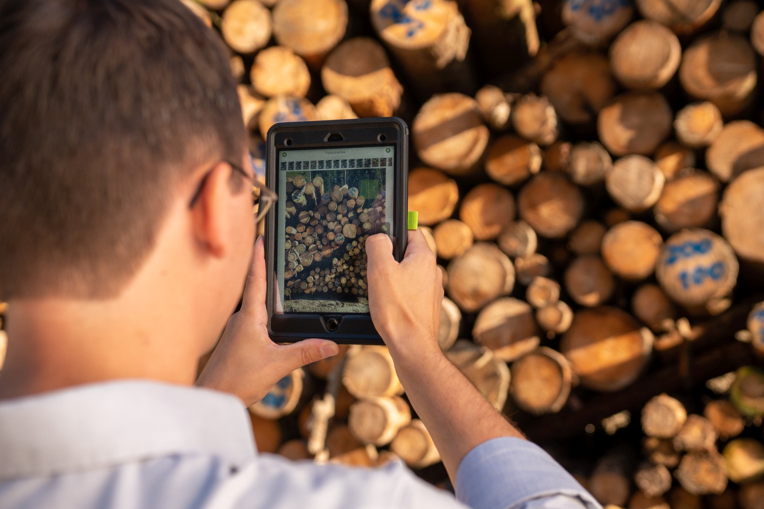
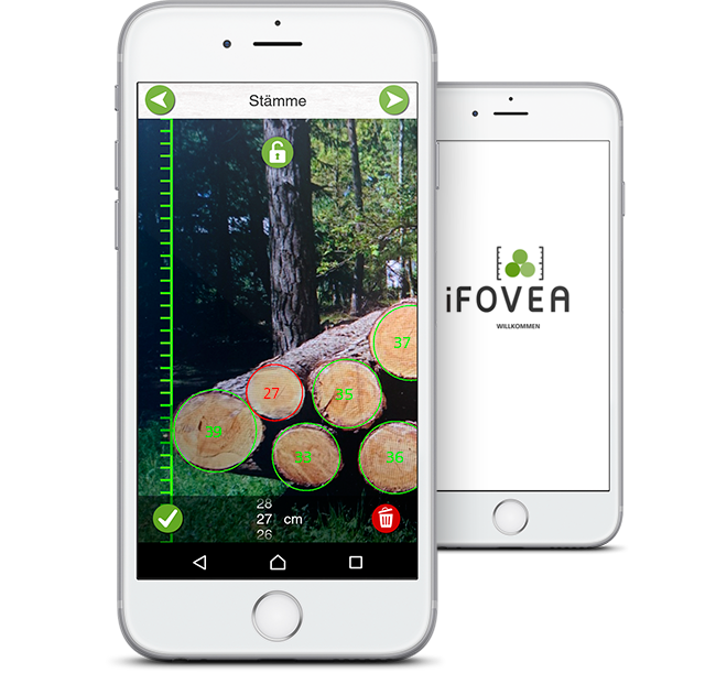
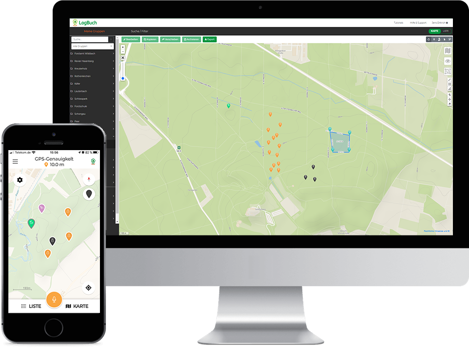
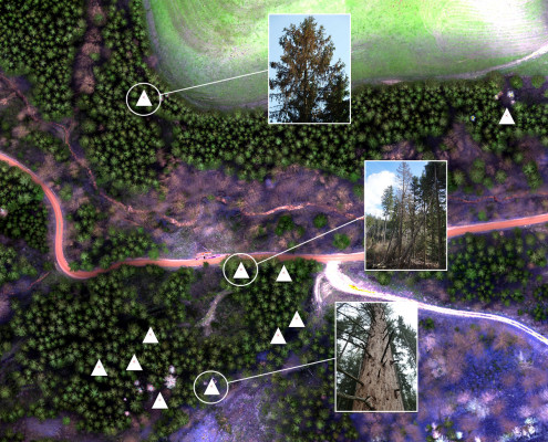
<td height="60" style="height:60px;width:600px;">In the project FINT-CH a methodology for the large-scale characterization of forest structures, thereon a better detection of single trees on the basis of remote sensing data, is under development. Top height, cover and mixture ratio get determined.&nbsp;</td> </tr> </tbody> </table>
Digital lösning
Yes
Sammandrag
In the project FINT-CH a methodology for the large-scale characterization of forest structures, thereon a better detection of single trees on the basis of remote sensing data, is under development. By using segmentation, stand boundaries and the corresponding top height, cover and mixture ratio get determined. This forms the basis for the specific single tree detection using forest structures. Large-scale geodata with valuable forest information can be generated. Their usage in practice are demonstrated on the basis of four examples.Vector-geodata (type polygon) with stand boundaries and the following attributes:
- Basic shape (uniform, unequally)
- Top height (hdom)
- Cover ratio
- Mixture ratio
- Stem number of upper-class trees
- Basal area of upper-class trees                   Vector-geodata (type points) with detected single trees and the following attributes:
- Top height
- BHD
- Social status in the upper-class
-Z-trees

Vector-geodata (type polygon) with forest gaps, boundaries and aisle                                                  The methodology should be able to get a simple and large-scale investigation every 5 to 10 years regarding the mentioned data attributes mentioned beforehand. With these attributes conclusions are possible regarding stem numbers of different classes, protective forest investigations, mapping of forest gaps, boundaries and aisle as well as on stock estimations and finally operational planning (allowable cut, activity planning… )

Ägare eller författarorganisation
BFH Bern University of Applied Sciences
Namn på ägaren eller författaren
Luuk Dorren
Rapportör
BFH Berne University of Applied Sciences
Namn på rapportören
Moritz Dreher
E-post till rapportören
Huvudbild
BP - Rosewood - V1
NO
Upphovsland
Schweiz
Titel (nationellt namn)
Einzelbaumerkennung
Potential
Projekt som detta factsheet skapats inom
Har video
no
Engelska
E-postadress för ägaren eller författaren
Voting
0%
Kort beskrivning
<table border="0" cellpadding="0" cellspacing="0" style="width:516px;" width="516"> <tbody> <tr height="60"> <td height="60" style="height:60px;width:516px;">FESTMETER Wöls Ltd. offers vitality analyses with a focus on bark beetle detection in coniferous forests.</td> </tr> </tbody> </table>
Digital lösning
Yes
Sammandrag

Festmeter Wöls Ltd. offers vitality analyses with regard to bark beetle detection in coniferous forests. Using the carrier systems multicopter or light aircraft, forest plots are flown over in a grid system and aerial photographs are taken with a special camera, which are later analysed and evaluated on the computer. The technology used makes vitality restrictions visible, changes in the water content of the needles can be seen, but not the exact cause, such as the bark beetle itself. However, since image series from at least two flights at different times are compared, many other causes such as drought stress can be excluded and the bark beetle can be traced very closely.  Initial trees are identified in the analysis, while the decision on necessary measures remains with the qualified on-site staff. A 100% hit rate is impossible. The aim should be to be able to act faster and more purposefully in the field. Long-standing customers report positive hit rates of over 80%. 

Ägare eller författarorganisation
Festmeter Wöls GmbH
Namn på ägaren eller författaren
Dr. Kurt Wöls
Rapportör
Holzcluster Steiermark GmbH
Namn på rapportören
DI Masa Jasarevic
E-post till rapportören
Huvudbild
Logo, huvudorganisation
Ytterligare bild 1
BP - Rosewood - V1
NO
Upphovsland
Österrike
Titel (nationellt namn)
Borkenkäfer-Erkennung
Projekt som detta factsheet skapats inom
Har video
no
Engelska
Innovasion
Yes
E-postadress för ägaren eller författaren
Voting
0%
Startår
2009
Kort beskrivning
<table border="0" cellpadding="0" cellspacing="0" style="width:499px;" width="499"> <tbody> <tr height="100"> <td height="100" style="height:101px;width:499px;">A single electronic register of Ukrainian timber. The system enables to track the timber origin and it represents digitally the supply chain from forest to the buyer at the first processing facility.</td> </tr> </tbody> </table>
Digital lösning
Yes
Type av lösning
Sammandrag

Electronic timber tracking is a single electronic register of Ukrainian timber. Permanent forest users are obliged to electronically tag each log (or in case of firewood each batch) enabling to establish the legality of its harvesting, namely: description of the log, place and time, name of the team that carried out the procurement, transport document. Thus the system digitally represents the supply chain from forest to the buyer at the first processing facility. Electronic timber accounting has been implemented in Ukraine in phases since 2009, and is still running. At first the system was used only by permanent users under the State Agency of Forest Resources of Ukraine (SFRA) and since 2020 it becomes obligatory to all permanent forest users in Ukraine. 

Technology, equipment and software come from Latchbacher (AT) and are adapted to the Ukrainian conditions. For foresters, as key users, the system decreases the time to register, process and report on sales of unprocessed timber. At the same time, it is also freely accessible for the general public on the website. Anyone can track the legality of timber origin knowing the number of the tag, or invoice number, or truck license plate. As of December 2019 electronic timber tracking is carried out by 504 enterprises (incl. 297 enterprises of the SFRA). Ministries and agencies are also connected to the system for control and information exchange purposes. In total, more than 3,700 mobile users are connected.  

Ägare eller författarorganisation
State Enterprise "Forestry Innovation and Analytical Center"
Namn på ägaren eller författaren
Yuriy Sotnyk
Rapportör
NGO FORZA
Namn på rapportören
Lesya Loyko
E-post till rapportören
Titel resurs 1
Overview of Electronic Tracking of Timber in Ukraine given in the World Bank Ukraine country forest note, 2020
Huvudbild
Logo, huvudorganisation
Projektlogo
BP - Rosewood - V1
NO
Upphovsland
Ukraina
Titel (nationellt namn)
Електронний облік деревини
Potential
Projekt som detta factsheet skapats inom
Rosewood Video
Watch video
Electronic Timber Tracking (Ukraine)
Har video
yes
Engelska
Innovasion
Yes
E-postadress för ägaren eller författaren
Mobiliseringspotential
11000000 m3/y
Typ av trä
logwood, primer material
Hållbarhets potential
very positive
Påverkan på miljö & biologisk mångfald
protection
Enkel implementering
difficult
ekonomisk påverkan
Transparancy
Effekt antal anställda
minor impact
Ekonomisk effekt
minor impact
Specifika kunskapsbehov
Digitalization
Nyckel förutsättningar
political decision
Voting
0%
Startår
2021
Kort beskrivning
<table border="0" cellpadding="0" cellspacing="0" style="width:660px;" width="660"> <tbody> <tr height="477"> <td height="477" style="height:478px;width:660px;">InspectorulPadurii.ro is initiated by Ministry of Environment, Waters and Forests together with the Government of Romania with the aim to make transparent the wood harvesting activity, transport of wood in entire Romania.&nbsp;</td> </tr> </tbody> </table>
Digital lösning
Yes
Type av lösning
Vedens ursprung
Trätyp
kommersiell potential
high
Sammandrag

 The online portal is an automatic method for identifying illegally cut timber transports from Romania. The users are able to observe alerts from satellites indicating information and once every few days (between 2 and 7 days depending on the satellite) any change in the aerial image associated with the forest vegetation in Romania. The portal also accesses the SUMAL database of the Ministry of Water and Forests in real time. From this database, information is extracted to be processed in the internal system, about the enhancement documents on wood harvests, the locations from where the timber transports are loaded and the information related to these points.The permits on wood harvest became digitalized, therefore all harvesting activity can be checked by satellite monitoring while the transports must obtain a unique code before leaving the place of loading. This code is only obtained after the transport information has been entered into the system, including the location where the code was requested.
The portal, through further developments, also contains an API (set learned of rules), which allows automatic access to all information publicly presented on this portal (layers, transport coordinates and related metadata, enhancement documents, etc.), so that other interested actors can make analyzes that will lead to stopping illegal logging.

Ägare eller författarorganisation
www.mmediu.ro
Namn på ägaren eller författaren
Tanczos Barna, Ministry of Environment, Water and Forests
Rapportör
ProWood
Namn på rapportören
Kadar Rezso
E-post till rapportören
Huvudbild
Logo för best practice
Enkel implementering - Utvärdering
Difficult
BP - Rosewood - V1
NO
Hållbarhets potential - Värde
Very Positive
Titel (nationellt namn)
Radarul Pădurilor
Potential
Projekt som detta factsheet skapats inom
Rosewood Video
Watch video
PRO WOOD - Romania's timber tracking system SUMAL 2.0
Har video
yes