Platformy z danymi, centra danych, otwarte dane

Polski
Innowacja
Yes
Właściciel lub autor e-mail
Voting
0%
Rok rozpoczęcia
2009
Krótki opis
Kompleksowy system wspomagający organizację pracy w parkach narodowych, lasach miejskich i komunalnych oraz leśnych zakładach doświadczalnych, obejmujący swoim zakresem codzienne gospodarowanie w danej jednostce oraz specyficzne zadania wynikające z ochrony przyrody.
Rozwiązanie cyfrowe
Yes
Rodzaj rozwiązania
Abstrakt

System LasInfo jest kompleksowym produktem składającym się z kilku powiązanych ze sobą aplikacji. Przeznaczony jest dla parków narodowych, lasów miejskich i komunalnych oraz leśnych zakładów doświadczalnych. Umożliwia on zarówno zarządzanie gruntami leśnymi oraz monitorowanie pozyskania i obrotu drewnem, jak również realizację zadań planu ochrony i monitoring przyrodniczy.

Rozwiązanie składa się z czterech podstawowych modułów: centralnej bazy danych, aplikacji LasInfo Klient, Aplikacji GIS oraz Rejestratora leśniczego. Pozwala to na skoordynowane zarządzanie takimi elementami jak ochrona przyrody, gospodarka leśna, dane przestrzenne i dane ewidencyjne. Możliwe jest dostosowanie rozwiązań do poszczególnych użytkowników poprzez wdrożenie tylko niektórych lub wszystkich elementów systemu. Wspólna baza danych eliminuje z kolei problem niezgodności pomiędzy różnymi systemami i formatami danych.

Elementy systemu LasInfo:

  • Oprogramowanie: centralna baza danych, aplikacja LasInfo, aplikacja LasInfo Obrót Drewnem, Mapa Numeryczna, Monitoring Przyrodniczy, Mobilny GIS.
  • Urządzenia/infrastruktura: serwer (lokalny lub "w chmurze"), urządzenia sieciowe i VPN, urządzenia mobilne.

Funkcje systemu Lasinfo:

  • ewidencja stanu posiadania: ewidencja powszechna, opis taksacyjny;
  • system planów (zadań ochronnych): szacunki brakarskie, zakładanie pozycji planów, obsługa przetargów, ewidencja wykonania (zlecenie prac, odbiór prac);
  • obrót drewnem: dokumenty przychodu i rozchodu drewna, umowy na drewno, magazyn drewna, rejestrator leśniczego;
  • dokumenty ochrony i hodowli lasu: inwentaryzacja posuszu, ewidencja pożarów, protokół oceny upraw, protokół uznania oceny odnowień naturalnych;
  • raportowanie: zaplanowanych prac, obrotu drewnem, zleceń/wykonań;
  • mapa numeryczna: standard Leśnej Mapy Numerycznej, standard danych GIS w ochronie przyrody, monitoring przyrodniczy, raportowanie na mapie, GIS mobilny.

System został wdrożony w 11 polskich parkach narodowych, ponadto wśród użytkowników LasInfo znajdują się leśne zakłady doświadczalne (Murowana Goślina, Siemianice, Rogów, Krynica–Zdrój), zarządcy lasów miejskich i komunalnych oraz urzędy morskie zarządzające terenami leśnymi.

Właściciel lub organizacja autorska
Taxus IT Sp. z o.o.
Właściciel lub twórca
Sylwester Kulik
Organizacja reporterska
Łukasiewicz Research Network - Wood Technology Institute (ITD)
Osoba przygotowująca fiszkę
Dobrochna Augustyniak-Wysocka
Materiał dodatkowy 1 - tytuł
LasInfo broszura
Materiał dodatkowy 1 - wgraj plik
Zdjęcie główne
Logo organizacji
Dodatkowe materiały 1
Hub
Central-East Hub
BP - Rosewood - V1
NO
Kraj pochodzenia
Polska
Tytuł (w języku narodowym)
[EN] Integrated information system for national parks, nature conservation and forest management
Skala aplikacji
Projekt, w ramach którego stworzona została niniejsza fiszka
Posiada wideo
no
Ukraiński
Innowacja
No
Właściciel lub autor e-mail
Główna kategoria
Voting
0%
Tytuł (akronim)
BDL
Krótki opis
Сховище даних, мета якого – збір, обробка й обмін інформацією про ліси всіх форм власності в Польщі. Дані доступні в описовій та картографічній формі через Інтернет-портал і мобільний додаток.
Rozwiązanie cyfrowe
Yes
Rodzaj rozwiązania
Abstrakt

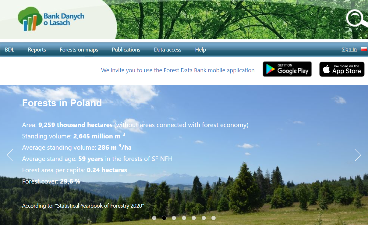
Банк даних про ліси – це сховище даних, мета якого – збір, обробка й обмін інформацією про ліси всіх форм власності в Польщі.

Він також спрямований на підтримку наукових досліджень, проведення аналізу та прогнозування лісових ресурсів і просування стандартів збору й обробки даних про природні ресурси.

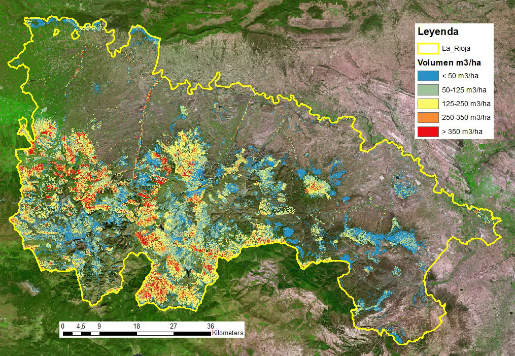
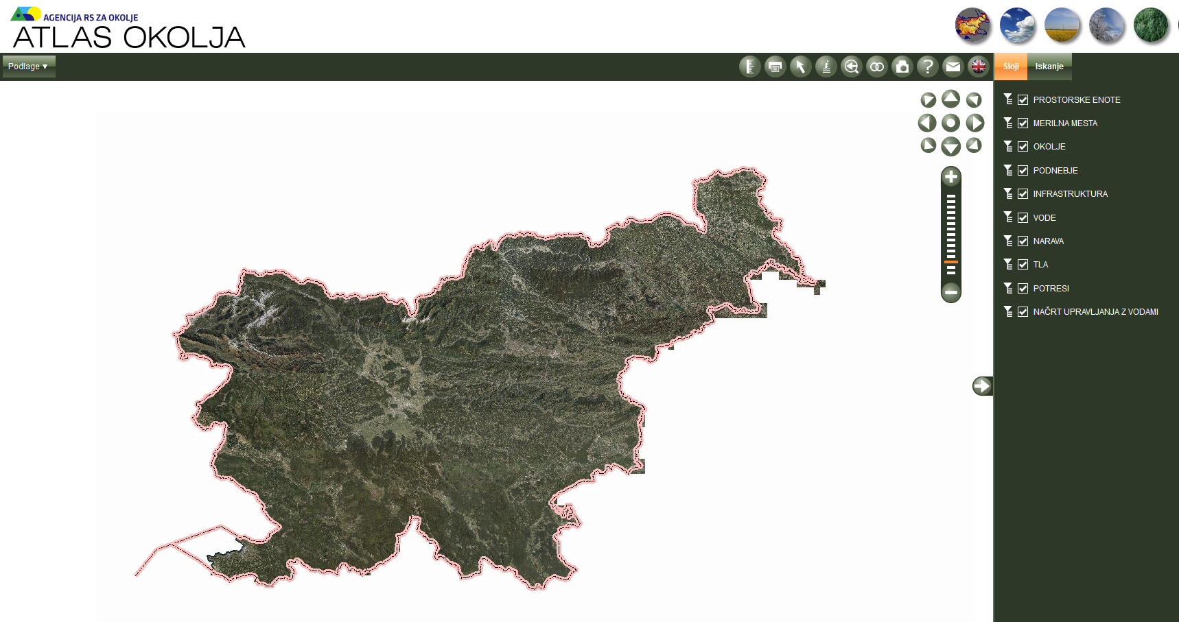
BDL містить дані як в описовій, так і в картографічній формі. Обсяг доступних даних включає таксаційні дані лісових насаджень, дані прогнозування, а також додаткову інформацію, зокрема про охорону лісів, протипожежне впорядкування, охорону природи, моніторинг навколишнього середовища, гідрологію, кліматологію, геологію, географічне районування, функціональні зони лісів, лісонасіннєве районування, Державний реєстр меж тощо.

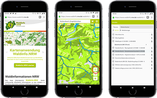
Банк даних про ліси можна використовувати через Інтернет-портал (на якому також містяться звіти, публікації та карти) або мобільний додаток (mBDL), який пропонує доступ до карт і навігації.

Основною цільовою групою є лісівники, але BDL також використовується в цілях просторового планування, наукових досліджень, ведення державної та міжнародної статистики і туризму. Він надає дані на центральному, регіональному та місцевому рівнях й охоплює близько 95% лісів Польщі (одне з найповніших сховищ лісових даних порівняно з іншими країнами з подібними системами). Щомісяця портал BDL відвідують понад 25 тисяч користувачів. 

Właściciel lub organizacja autorska
Бюро з управління лісовими ресурсами та геодезії
Właściciel lub twórca
Бюро з управління лісовими ресурсами та геодезії
Organizacja reporterska
Науково-дослідна мережа Лукасевича - Інститут деревинних технологій (ITD)
Osoba przygotowująca fiszkę
Доброхна Августиняк-Висоцька
Materiał dodatkowy 1 - tytuł
Best practice - short article
Zdjęcie główne
Hub
Central-East Hub
BP - Rosewood - V1
NO
Kraj pochodzenia
Polska
Tytuł (w języku narodowym)
Bank Danych o Lasach
Skala aplikacji
Projekt, w ramach którego stworzona została niniejsza fiszka
Rosewood Video
Obejrzyj wideo
Forest Data Bank Poland
Posiada wideo
yes
Angielski
Innowacja
Yes
Właściciel lub autor e-mail
Wpływ na gospodarkę
Very positive because the need to travel is significantly reduced.
Efekty w zakresie zatrudnienia
Positive because the quality and efficiency of work can be significantly improved
Efekty ekonomiczne
Remarkable savings in travelling costs
Wymagana wiedza specjalistyczna
Not any specific knowledge needed
Kluczowe wymagania
Mediacore IT skills
Główna kategoria
Voting
0%
Rok rozpoczęcia
2020
Krótki opis
Edukai Remote Services provides training and support services tailored to customer-specific remote needs.
Rozwiązanie cyfrowe
Yes
Rodzaj rozwiązania
Potencjał w zakresie komercjalizacji

High

Abstrakt

The Edukai Remote Services customer process helps you to find just the right solutions for your needs. We are able to effectively combine the desired remote software and various devices into an easy-to-operate, customer-looking entity. This saves our customers’ resources for the actual core business. Edukai Remote services is one part of Edukai Oy’s extensive training supply, and the developed methods enables the traditional training in virtual classrooms regardless of location.
Właściciel lub organizacja autorska
Edukai Remote Services
Właściciel lub twórca
Ari Kananen
Organizacja reporterska
Lapland University of Applied Sciences
Osoba przygotowująca fiszkę
Anne Saloniemi
Zdjęcie główne
Logo dobrej praktyki
Dodatkowe materiały 1
Dodatkowe materiały 2
Łatwość wdrożenia - Ocena
Easy
Hub
Northern Hub
BP - Rosewood - V1
NO
Kraj pochodzenia
Finlandia
Tytuł (w języku narodowym)
Edukai Etäpalvelut
Skala aplikacji
Projekt, w ramach którego stworzona została niniejsza fiszka
Rosewood Video
Posiada wideo
yes
Francuski
Innowacja
Yes
Właściciel lub autor e-mail
Potencjał dla mobilizacji drewna
Uno de los casos desarrollados es CAMBRIC: orientado a simular la evolución de las masas forestales y la calidad de la madera en distintos escenarios de gestión forestal.
Rodzaj drewna
Bois provenant de peuplements forestiers présentant un risque d'incendie en raison d'une forte concentration de matériaux combustibles, et de peuplements forestiers au développement incertain pouvant simuler cette plate-forme.
Potencjał dla zrównoważonego rozwoju
Fort
Wpływ na środowisko i bioróżnorodność

Très élevé car il aidera à protéger les forêts des incendies pour une meilleure gestion.

Łatwość wdrożenia
"Consommer des données ouvertes" n'est pas facile, il faut donc créer des liens intermédiaires et des équipes pluridisciplinaires pour rapprocher les nouvelles technologies des utilisateurs afin de concevoir des solutions utiles.
Wpływ na gospodarkę
Élevée, car l'information facilite la gestion et la prévision des travaux forestiers à effectuer.
Efekty w zakresie zatrudnienia
Le projet n'a pas d'effet direct sur l'emploi, mais il ouvre des possibilités aux entrepreneurs et aux entreprises, car les informations publiées permettent à tout utilisateur ayant le profil approprié de lancer des requêtes et de développer des outils.
Wymagana wiedza specjalistyczna
Moyennement, une certaine connaissance des outils cartographiques et forestiers est nécessaire.
Koszt implementacji

Budget :
Total accepté : 1.637.690 EUR
Contribution totale du CEF : 1.228.268,00 (75% des coûts éligibles)

Kluczowe wymagania

La technologie est déjà développée, les exigences sont similaires à celles nécessaires à l'utilisation de tout autre logiciel similaire.

Voting
0%
Rok rozpoczęcia
2018
Rok zakończenia
2021
Tytuł (akronim)
CROSS-FOREST
Krótki opis
Cross-Forest vise à publier des ensembles de données d'inventaires forestiers et de cartes forestières du Portugal et de l'Espagne au format Linked Open Data (LOD), et à les combiner pour créer et intégrer des modèles qui soutiennent la gestion et la protection des forêts.
Rozwiązanie cyfrowe
Yes
Rodzaj rozwiązania
Pochodzenie surowca drzewnego
Potencjał w zakresie komercjalizacji

Les résultats obtenus jusqu'à présent démontrent l'utilité et la polyvalence de la technologie LOD, car elle permet aux utilisateurs d'accéder librement à des données actualisées et de les gérer pour développer des outils adaptés à leurs besoins et à leurs objectifs. 

La technologie LOD permet la construction modulaire et interconnectée d'une infrastructure d'information ouverte, publique et de qualité à la disposition du secteur. La continuité de ce type de publication permet aux administrations publiques de répondre à leurs obligations de transparence, d'optimiser les ressources et de garder un contrôle statistique de l'utilisation de l'information.

Abstrakt

Cross-Forest développe une plateforme commune de données forestières ouvertes et un modèle de données transfrontalier (ontologie) partagé entre le Portugal et l'Espagne, pour la publication d'inventaires forestiers, de cartes et d'autres bases de données forestières au format Linked Open Data (LOD). Cross-Forest fournira un dépôt public (endpoint) pour la publication des données forestières selon le modèle produit. L'objectif principal est de maintenir les informations forestières toujours disponibles et mises à jour afin de faciliter leur exploitation par tous les agents impliqués dans la gestion et la recherche forestières.

Deux cas d'utilisation sont en cours d'élaboration :
CAMBRIC - orienté pour simuler l'évolution des peuplements forestiers et de la qualité du bois dans différents scénarios de gestion forestière.
FRAME - axé sur la prévision du comportement et de la propagation des feux de forêt grâce à des informations précises sur les matériaux combustibles, des cartes forestières et des modèles de propagation.

Des ressources de calcul haute performance (HPC) sont utilisées en raison de la quantité de données générées et gérées, et de la complexité des modèles.

Les résultats obtenus jusqu'à présent démontrent l'utilité et la polyvalence de la technologie LOD, car elle permet aux utilisateurs d'accéder librement à des données actualisées et de les gérer pour développer des outils adaptés à leurs besoins et à leurs objectifs. La publication des données sous forme de LOD permet aux administrations publiques de répondre facilement à leurs exigences en matière de transparence et de publicité, d'optimiser leurs ressources et de garder un contrôle statistique sur l'utilisation des données publiques.

Właściciel lub organizacja autorska
Groupe Tragsa
Właściciel lub twórca
Asunción Roldan Zamarrón
Organizacja reporterska
Fundación Cesefor
Osoba przygotowująca fiszkę
Ángela García
Projekt
Cross-Forest est cofinancé par l'Agence exécutive pour l'innovation et les réseaux (INEA) de l'Union européenne, par le biais du Connecting Europe Facility (CEF) 2014-2020. Action 2017-EU-IA-0140 (Accord n° INEA/CEF/ICT/A2017/1566738)
Zdjęcie główne
Logo dobrej praktyki
Logo organizacji
Logo projektu
Koszt implementacji (Euro - €)
1637690.00 €
Łatwość wdrożenia - Ocena
Very difficult
Hub
South-Western Hub
BP - Rosewood - V1
NO
Potencjał dla zrównoważonego rozwoju - Wartość
Very Positive
Kraj pochodzenia
Hiszpania
Portugalia
Tytuł (w języku narodowym)
Armonización CROSS & modelización HPC de datos forestales
Skala aplikacji
Projekt, w ramach którego stworzona została niniejsza fiszka
Posiada wideo
no
Angielski
Innowacja
Yes
Właściciel lub autor e-mail
Potencjał dla mobilizacji drewna
High, through public, user-friendly, easily accessible information about the site conditions of forest areas in NRW. For forest owners or forestry contractors, fact-based forest management or planning of harvesting operations are supported.
Rodzaj drewna
All types of wood
Potencjał dla zrównoważonego rozwoju
Data-based local, site-specific and individual support for sustainable forest management.
Wpływ na środowisko i bioróżnorodność

The included map-based information on soil conditions, meteorological data, climate scenarios have been interlinked with the Reforestation Concept and the Forest Management Concept of the state NRW. Increasing biodiversity and forest resilience by introducing mixed, multi-cohort forest stands is at the core of these concepts which are based on specific, locally site-adapted "forest development types". The platform is public, available also on mobile devices and user friendly. The usability is constantly tested and improved.

Id: 2861876
Continent Code: EU
Country Code: DE
Country Name: Germany
Name: North Rhine-Westphalia
Łatwość wdrożenia
The difficulty lies in the (public) availability of the different databases and the cooperation of the services behind them.
Wymagana wiedza specjalistyczna
Integration of geoinformation, geological and meteorological services, forest management & development, ecology
Kluczowe wymagania

The platform is based on the Open Data NRW strategy and draws significantly on the broad availability of geological data provided by the Geological Service North-Rhine Westphalia. The promotion of geoinformation data and their public availability in NRW has a longstanding tradition. In addition, the collboration of these public stakeholders (IT NRW, Geological Service NRW, State Enterprise Forest and Timber NRW) has been actively developed over many years.

Główna kategoria
Voting
0%
Krótki opis
Information platform on forests in NRW incl. interactive digital maps on forest cover, ecology, geology, types of use and calamities.
Rozwiązanie cyfrowe
Yes
Rodzaj rozwiązania
Potencjał w zakresie komercjalizacji

Cost-free public service

Abstrakt

The internet portal Waldinfo.NRW offers comprehensive public information on the forests in North Rhine-Westphalia, their diverse functions and sustainable management. This primarily includes digital maps on various aspects of forests, forest management and the use of forests by the public. The topics covered by the various maps range from forest cover and forest ecology, forest management and forest nature conservation to recreational use, danger prevention and forest administration. The information provided is intended in particular to support forest owners in the adaptation of forest management to climate change. This also includes forest regeneration on the current large damaged areas. The selection of maps and the design of the user interface provide user-friendly access to the specialist information. The portal also refers to selected important specialist publications of the State Forestry Administration and further websites of the State Administration. The internet portal Waldinfo.NRW is an important component of the NRW Forest Information System and the NRW Forest Climate Adaptation Strategy. The digital offer of public forest information also corresponds to the Open Data process in North Rhine-Westphalia (Open.NRW).

Właściciel lub organizacja autorska
Ministerium für Umwelt, Landwirtschaft, Natur- und Verbraucherschutz des Landes Nordrhein-Westfalen
Organizacja reporterska
Landesbetrieb Wald und Holz NRW
Osoba przygotowująca fiszkę
Marie-Charlotte Hoffmann, Elke Hübner-Tennhoff
Zdjęcie główne
Logo dobrej praktyki
Logo organizacji
Dodatkowe materiały 1
Dodatkowe materiały 2
Dodatkowe materiały 3
Łatwość wdrożenia - Ocena
Medium
Hub
Central-West Hub
Region pochodzenia
2861876
BP - Rosewood - V1
NO
Potencjał dla zrównoważonego rozwoju - Wartość
Very Positive
Kraj pochodzenia
Niemcy
Tytuł (w języku narodowym)
Waldinformationssystem NRW
Skala aplikacji
Projekt, w ramach którego stworzona została niniejsza fiszka
Rosewood Video
Obejrzyj wideo
Unser Wald im Klimawandel (2019)
Posiada wideo
yes
Francuski
Innowacja
Yes
Właściciel lub autor e-mail
Voting
0%
Rok rozpoczęcia
2017
Krótki opis
<table border="0" cellpadding="0" cellspacing="0" style="width:412px;" width="412"> <tbody> <tr height="60"> <td height="60" style="height:60px;width:412px;">eMOBOIS est une plateforme facilitant l'échange d'informations entre les entreprises de l'industrie forestière et papetière : entrepreneurs forestiers, acheteurs de bois, transporteurs, scieries, papeteries, autres clients du bois. Elle est basée sur la standardisation des données et des languages informatiques.</td> </tr> </tbody> </table>
Rozwiązanie cyfrowe
No
Abstrakt

Les outils informatiques se développent de plus en plus dans les entreprises de la filière Forêt-Bois. Cette informatisation s’accompagne d’un besoin accru de données numériques. Dans ce contexte, eMOBOIS propose un cadre pour faciliter la mise en relation des systèmes informatiques. L’élément fondateur du projet est la standardisation des données et des échanges de données. L’objectif d’eMOBOIS est donc de faciliter les échanges d’information entre deux entreprises impliquées dans le processus d’approvisionnement des bois. L’utilisation au moment de l’échange d’un langage commun est proposée pour éviter de multiplier le développement d’interfaces informatiques. eMOBOIS se concentre sur la transaction de données d’une entreprise vers une autre. Il n’y a pas d’ingérence dans les choix informatiques des entreprises ni dans le traitement des données par les entreprises. La démarche est compatible avec la diversité des solutions informatiques rencontrée. Les avantages principaux sont un gain de temps considérable, une meilleure sécurité et fiabilité des échanges, une communication plus facile entre les acteurs, ainsi qu'une mise à jour en temps réel des stocks.

Właściciel lub organizacja autorska
EDT
Organizacja reporterska
CNPF
Osoba przygotowująca fiszkę
Henri Husson
E-mail reportera
Materiał dodatkowy 1 - tytuł
Flyer de présentation
Materiał dodatkowy 1 - wgraj plik
Zdjęcie główne
Logo dobrej praktyki
Logo organizacji
Dodatkowe materiały 1
BP - Rosewood - V1
NO
Kraj pochodzenia
Francja
Tytuł (w języku narodowym)
eMOBOIS
Skala aplikacji
Projekt, w ramach którego stworzona została niniejsza fiszka
Posiada wideo
no
Hiszpański
Innowacja
Yes
Właściciel lub autor e-mail
Voting
0%
Rok rozpoczęcia
2018
Rok zakończenia
2021
Tytuł (akronim)
CROSS-FOREST
Krótki opis
<table border="0" cellpadding="0" cellspacing="0" style="width:611px;" width="611"> <tbody> <tr height="60"> <td height="60" style="height:60px;width:611px;">Cross-Forest tiene como objetivo publicar conjuntos de datos de inventarios forestales y mapas forestales de Portugal y España en formato Linked Open Data (LOD), y combinarlos para crear e integrar modelos que apoyen la gestión forestal y la protección de los bosques</td> </tr> </tbody> </table>
Rozwiązanie cyfrowe
Yes
Rodzaj rozwiązania
Abstrakt
Cross-Forest está desarrollando una plataforma común de datos forestales abiertos y un modelo de datos transfronterizo (ontología) compartido entre Portugal y España, para la publicación de inventarios forestales, mapas y otras bases de datos forestales en formato Linked Open Data (LOD). Cross-Forest proporcionará un repositorio público (endpoint) de publicación de Datos Forestales según el modelo producido. El objetivo principal se centra en mantener la información forestal siempre disponible y actualizada para facilitar su explotación a todos los agentes implicados en la gestión e investigación forestal.
Se están desarrollando dos casos de uso:
CAMBRIC - orientado a simular la evolución de las masas forestales y la calidad de la madera en distintos escenarios de gestión forestal.
FRAME – enfocado a la predicción del comportamiento y propagación de los incendios forestales a través de información precisa sobre materiales combustibles, mapas forestales y modelos de propagación.
Se emplean recursos de computación de alto rendimiento (HPC) debido a la cantidad de datos generados y gestionados, y a la complejidad de los modelos.
Los resultados obtenidos hasta ahora demuestran la utilidad y versatilidad que proporciona la tecnología LOD, ya que permite a los usuarios acceder y gestionar libremente datos actualizados para desarrollar herramientas adaptadas a sus necesidades y propósitos. La publicación de datos como LOD permite a las Administraciones Públicas cumplir fácilmente con sus requisitos de transparencia y publicidad, optimizar recursos y llevar un control estadístico del uso de los datos públicos.
Właściciel lub organizacja autorska
Grupo Tragsa
Właściciel lub twórca
Asunción Roldan Zamarrón
Organizacja reporterska
CESEFOR
Osoba przygotowująca fiszkę
Ángela García de Arana
Projekt
"Cross-Forest está cofinanciado por la Agencia Ejecutiva de Innovación y Redes (INEA) de la Unión Europea, a través del Mecanismo Conectar Europa (CEF) 2014-2020. Acción 2017-EU-IA-0140 (Acuerdo nº INEA/CEF/ICT/A2017/1566738)"
Zdjęcie główne
Logo organizacji
Logo projektu
Dodatkowe materiały 1
Dodatkowe materiały 2
Dodatkowe materiały 3
BP - Rosewood - V1
NO
Kraj pochodzenia
Hiszpania
Tytuł (w języku narodowym)
Armonización CROSS & modelización HPC de datos forestales
Skala aplikacji
Projekt, w ramach którego stworzona została niniejsza fiszka
Posiada wideo
no
Grecki
Innowacja
Yes
Właściciel lub autor e-mail
Voting
0%
Rok rozpoczęcia
2016
Rok zakończenia
2017
Tytuł (akronim)
FORCIP+
Krótki opis
<table border="0" cellpadding="0" cellspacing="0" style="width:252px;" width="252"> <tbody> <tr height="95"> <td height="95" style="height:95px;width:252px;">Το έργο στοχεύει στη βελτίωση της χρήσης του αγροτικού οδικού δικτύου σε περίπτωση έκτακτης ανάγκης, ιδίως δασικών πυρκαγιών.&nbsp;</td> </tr> </tbody> </table>
Rozwiązanie cyfrowe
Yes
Rodzaj rozwiązania
Abstrakt

Μέσω της διακρατικής συνεργασίας θα είναι προσβάσιμο ένα ευρύ φάσμα καταλόγων υφιστάμενων οδικών υποδομών, θα ικανοποιούνται διαφορετικές απαιτήσεις και θα δημιουργηθεί ένα ομοιογενές μοντέλο.
Οι εφαρμογές ΤΠΕ θα αναπτυχθούν για τη βελτίωση της αποτελεσματικότητας της χρήσης και θα προτείνουν βελτιώσεις στη συντήρηση
Τα δασικά πυροσβεστικά οχήματα θα είναι εξοπλισμένα με δέκτες GNSS προκειμένου να βελτιωθεί η απόκριση του χρόνου και να αυξηθεί η εξοικονόμηση καυσίμου.
Οι ειδικοί της πυρκαγιάς θα μπορούν να χρησιμοποιούν την ανάλυση δικτύου για τον προγραμματισμό πόρων, να εντοπίζουν τα πιο κατάλληλα μέρη για εδάφη σημαίνει χώρους αναμονής ή να εντοπίζουν επιφάνειες δασών όπου απαιτείται περισσότερος χρόνος για πρόσβαση.
Άλλοι παράγοντες που εμπλέκονται σε καταστάσεις έκτακτης ανάγκης θα μπορούν να χρησιμοποιούν εφαρμογές διαχείρισης ιστού και δημόσιες πληροφορίες. 
Właściciel lub organizacja autorska
Laboratory of Photogrammetry and Remote Sensing, Aristotle University of Thessaloniki
Właściciel lub twórca
Petros Patias
Zdjęcie główne
BP - Rosewood - V1
NO
Kraj pochodzenia
Grecja
Tytuł (w języku narodowym)
Δασικοί δρόμοι για πολιτική προστασία
Projekt, w ramach którego stworzona została niniejsza fiszka
Posiada wideo
no
Angielski
Innowacja
Yes
Właściciel lub autor e-mail
Voting
0%
Rok rozpoczęcia
2016
Rok zakończenia
2017
Tytuł (akronim)
FORCIP+
Krótki opis
<table border="0" cellpadding="0" cellspacing="0" style="width:361px;" width="361"> <tbody> <tr height="95"> <td height="95" style="height:95px;width:361px;">The project aims at improving the use of the rural road network in case of emergency, especially forest fires. ​</td> </tr> </tbody> </table>
Rozwiązanie cyfrowe
Yes
Rodzaj rozwiązania
Abstrakt

Through transnational cooperation a wide range of inventories of existing road infrastructure will be accessible, ​ different requirements will be met and a ​ homogeneous model will be established. ​ ICT applications will be developed to improve the efficiency of use and​ propose improvements on the maintenance​ ​Forest fire fighting vehicles will be equipped with GNSS receivers in order to improve time response and increase fuel savings.​ ​Fire specialists will be able to use network analysis for resources planning, locating most suitable places for ground means waiting areas or identifying forest surfaces where takes longer to access. ​ ​Other actors involved in emergencies will be able to use web management applications and public information.

Właściciel lub organizacja autorska
Laboratory of Photogrammetry and Remote Sensing, Aristotle University of Thessaloniki
Właściciel lub twórca
Petros Patias
Zdjęcie główne
Podpis pod zdjęciem głównym
Forest Roads for Civil Protection is a european project that aims at protecting forests from fires. ​
Logo dobrej praktyki
Logo organizacji
BP - Rosewood - V1
NO
Kraj pochodzenia
Grecja
Tytuł (w języku narodowym)
Δασικοί δρόμοι για πολιτική προστασία
Projekt, w ramach którego stworzona została niniejsza fiszka
Posiada wideo
no
Słoweński
Właściciel lub autor e-mail
Główna kategoria
Voting
0%
Rok rozpoczęcia
2013
Krótki opis
<table border="0" cellpadding="0" cellspacing="0" style="width:251px;" width="251"> <tbody> <tr height="60"> <td height="60" style="height:60px;width:251px;">Atlas okolja je spletna storitev, v okviru katere Agencija Republike Slovenije za okolje omogoča dostop do prostorskih vsebin najširšemu krogu uporabnikov. Rešitev je zasnovana na uporabi spletnih geoinformacijskih tehnologij.</td> </tr> </tbody> </table>
Rozwiązanie cyfrowe
Yes
Rodzaj rozwiązania
Abstrakt

Atlas okolja je okoljski informacijski sistem s prostorskimi podatki s področij narave, okolja, voda, tal, podnebja, infrastrukture in drugih podatkov na celotnem območju Slovenije. Baza podatkov je primer visokokakovostne in uporabne vsebine, ki je podprta s celovitimi opisi metapodatkov. Širši javnosti in strokovnim službam zagotavlja osnovne informacije o položaju, vsebini okoljskih podatkov in okoljskih pojavih.

Właściciel lub organizacja autorska
Slovenian Environment Agency
Organizacja reporterska
Slovenian Forestry Institute
Osoba przygotowująca fiszkę
Andreja Vedenik
Zdjęcie główne
Dodatkowe materiały 1
BP - Rosewood - V1
NO
Kraj pochodzenia
Słowenia
Tytuł (w języku narodowym)
Atlas okolja
Skala aplikacji
Projekt, w ramach którego stworzona została niniejsza fiszka
Posiada wideo
no