Modellazione, DSS, la simulazione, l'ottimizzazione

×

Messaggio di errore

  • Notice: Undefined index: #markup in bootstrap_preprocess_field() (linea 92 di /data/www/rosewood.admin.v4/sites/all/themes/bootstrap/template.php).
  • Notice: Undefined index: #markup in bootstrap_preprocess_field() (linea 92 di /data/www/rosewood.admin.v4/sites/all/themes/bootstrap/template.php).
  • Notice: Undefined index: #markup in bootstrap_preprocess_field() (linea 92 di /data/www/rosewood.admin.v4/sites/all/themes/bootstrap/template.php).
  • Notice: Undefined index: #markup in bootstrap_preprocess_field() (linea 92 di /data/www/rosewood.admin.v4/sites/all/themes/bootstrap/template.php).
Tedesco
Innovazione
Yes
potenziale di mobilitazione
Hoch, das Kompetenzzentrum Wald und Holz 4.0 unterstützt eine Vielzahl von Projekten und digitalen Lösungen, die die Holzmobilisierung fördern.
potenziale sostenibilità
KWH4.0 erhöht die Nachhaltigkeit durch intelligente Lösungen, die die Ressourceneffizienz bei der Holzernte verbessern oder durch Entscheidungsunterstützung eine nachhaltige Waldbewirtschaftung erleichtern.
Impatto sull'ambiente e la biodiversità

Projekte aus dem KWH4.0 Netzwerk wie etwa zum sensorgestützten Waldmonitoring helfen, die Widerstandsfähigkeit des Waldes gegenüber dem Klimawandel zu erhöhen.

Facilità di implementazione
Das KWH4.0 hat EFRE-Mittel erhalten, um seine Arbeit als Kompetenznetzwerk aufzunehmen. Entscheidend ist aber das Interesse der beteiligten Akteure aus Forst-und Holzwirtschaft und IKT an der engen Zusammenarbeit.
1 ° Dominio (principale)
Voting
0%
Inizio anno
2018
fine anno
2021
Breve descrizione
<table border="0" cellpadding="0" cellspacing="0" style="width:496px;" width="496"> <tbody> <tr height="60"> <td height="60" style="height:60px;width:496px;">Der Cluster Wald und Holz wird smart</td> </tr> </tbody> </table>
soluzione digitale
Yes
Abstract

Das „Kompetenzzentrum Wald und Holz 4.0“ entwickelt Industrie 4.0-Konzepte für den Cluster Wald und Holz. Mit intelligenten und dezentral agierenden Maschinen, Geräten, Diensten und Menschen werden Grundlagen für eine umfassende Digitalisierung gelegt. Die Optimierung der hochkomplexen Wertschöpfungsnetzwerke hilft dabei, aktuellen Herausforderungen aus Ökologie, Ökonomie und dem Klimawandel nachhaltig zu begegnen. Um Wald und Holz “smarter” zu machen, müssen in einem übergreifenden Ansatz Kompetenzen aus Wirtschaft, Wissenschaft und Verwaltung gebündelt werden. Das Kompetenzzentrum Wald und Holz 4.0 soll die notwendigen Organisations- und Infrastrukturen geschaffen, Know-how aufbauen und in konkreten Wald und Holz 4.0-Komponenten umsetzen. Dabei  dienen Smart Forest Labs als forstliche Experimentierlabors, in denen Komponenten, Systeme und Prozesse überprüft, Standardisierung vorangetrieben, Konzepte verbreitet sowie Akteure geschult werden. Konzepte und Standards werden laufend als praktische Empfehlungen veröffentlicht, eine erste Version der Kommunikationsinfrastruktur S3I (eine “Internet of Things” Anwendung zur dezentralen Vernetzung) ist eingerichtet. Hinzu kommt ein immer smarterer Fuhrpark: Forstmaschinen wurden bereits zum Abrufen digitaler Informationen (GPS-Position, Treibstoffverbrauch, Produktionsdaten usw.) erweitert und gleichzeitig über alternative Funkstandards mit Maschinen in Regionen vernetzt, in denen es keinen Mobilfunk gibt.

Proprietario o organizzazione dell'autore
RIF Institut für Forschung und Transfer e.V.
Nome del proprietario o dell'autore
Frank Heinze
Organizzazione di reporter
FBZ
Nome del reporter
Marie-Charlotte Hoffmann, Elke Hübner-Tennhoff
Immagine principale
Logo delle migliori pratiche
Ulteriore visiva 1
Ulteriore visiva 2
Ulteriore visiva 3
BP - Rosewood - V1
NO
Paese d'origine
Germania
Scala di applicazione
Progetto nell'ambito del quale questa scheda è stata creata
Ha un video
no
Tedesco
Innovazione
Yes
Voting
0%
Inizio anno
2018
fine anno
2021
Breve descrizione
<table border="0" cellpadding="0" cellspacing="0" style="width:573px;" width="573"> <tbody> <tr height="60"> <td height="60" style="height:60px;width:573px;">Das Fehlen von Standortskarten in der Steiermark bedingt einen neuen Ansatz bei der Standortserkundung und Kartierung der Waldstandorte. Daher soll eine Waldtypisierung auf Basis eines GIS-gestützten geoökologischen Stratifizierungsmodells erfolgen.</td> </tr> </tbody> </table>
soluzione digitale
Yes
Abstract

Das weitgehende Fehlen von Standortskarten in der Steiermark macht einen neuen Ansatz bei der Standortserkundung und Kartierung der vorkommenden Waldstandorte notwendig. Eine weitere wissenschaftliche Herausforderung stellt die Berücksichtigung von zukünftig veränderten Klimabedingungen dar, die sich auch auf die Klassifizierung von Standorten und Waldtypen auswirken wird. Für eine solcherart erforderliche „dynamische Standortsklassifizierung“ bestehen theoretische Konzepte, die konkrete Umsetzung einer integrierten Standorts- und Waldtypenklassifikation in einer realen Region wie der Steiermark stellt jedoch Neuland dar.
Im Rahmen des Projektes soll daher eine Waldtypisierung auf Basis eines GIS-gestützten geoökologischen Stratifizierungsmodells erfolgen. Als Datenbasis sollen das digitale Höhenmodell, eine geologische Basiskarte, digital vorliegende Standorts- und Klimadaten sowie neu zu erhebende Standortsparameter verwendet werden. Für die Waldtypenkarte sollen auf Grundlage der Punkt- und Flächendaten zunächst Themenkarten für die Faktoren Wärme, Wasser und Nährstoffhaushalt modelliert werden, die dann zu Waldtypen mit einheitlicher Faktorenkombination zusammengefasst werden. Das Modell erlaubt dann auf Basis der Datengrundlagen abgeleiteten digitalen geoökologischen Parametern (u.a. Höhenstufe, Hanglage, Substrat, Geländeform, Neigung) eine Stratifizierung der Waldtypen auf allen Hauptwaldstandorten. Jeder Waldtyp wird auf der Waldtypenkarte im Maßstab 1:25.000 dargestellt. Neben den ökologischen Fakten ist jeder Waldtyp mit einer waldbaulichen Beschreibung versehen, die Angaben zu den geeigneten Baumarten, Gefährdungen und möglichen Behandlungsvarianten in Hinblick auf den Klimawandel enthält. In dieser waldbaulichen Charakterisierung werden auch die bisherigen Erfahrungen mit den vorhanden Baumarten und ihren Mischungen getrennt nach Waldtypen beschrieben und Empfehlungen für die zukünftige Bestockung und deren Bewirtschaftung in Hinblick auf den Klimawandel gegeben.

Proprietario o organizzazione dell'autore
BOKU - Universität für Bodenkultur Wien
Organizzazione di reporter
Holzcluster Steiermark GmbH
Nome del reporter
DI Masa Jasarevic
Immagine principale
Logo della principale organizzazione
Ulteriore visiva 1
BP - Rosewood - V1
NO
Paese d'origine
Austria
Scala di applicazione
Progetto nell'ambito del quale questa scheda è stata creata
Rosewood Video
Guarda il video
FORSITE (Austria) - ROSEWOOD4.0 Best Practice & Innovation
Ha un video
yes
Slovacco
Innovazione
Yes
Proprietario o autore e-mail
Voting
0%
Inizio anno
2018
Titolo (abbreviazione)
reFlex
soluzione digitale
Yes
Abstract
Bezkontaktný prieskum lesných a nelesných ekosystémov. Stanovenie dendrometrických parametrov stromov, stav lesnej dopravnej siete.
Proprietario o organizzazione dell'autore
Národné lesnícke centrum - Lesnícky výskumný ústav
Nome del proprietario o dell'autore
Ivan Sačkov
Immagine principale
BP - Rosewood - V1
NO
Titolo (denominazione nazionale)
Diaľkový prieskum lesa
Scala di applicazione
Progetto nell'ambito del quale questa scheda è stata creata
Ha un video
no
Inglese
Innovazione
Yes
Proprietario o autore e-mail
potenziale di mobilitazione
Difficult to define, but if we base ourselves on the annual felling and the possibilities in La Rioja, it could be between 100,000 and 250,000 m3 of wood, but it would not be only through this system.
Tipo di legno in questione
Wood standing
potenziale sostenibilità
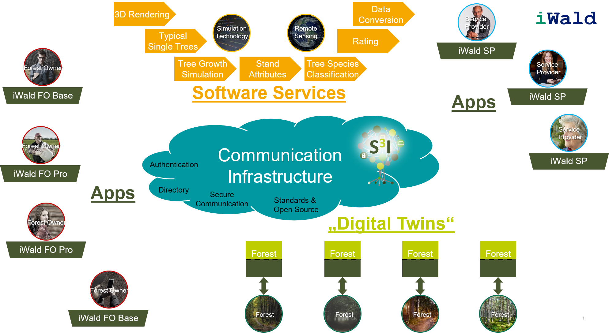
Facilitating sustainable forest management and the mobilisation of timber
Impatto sull'ambiente e la biodiversità

Difficult to estimate

Facilità di implementazione
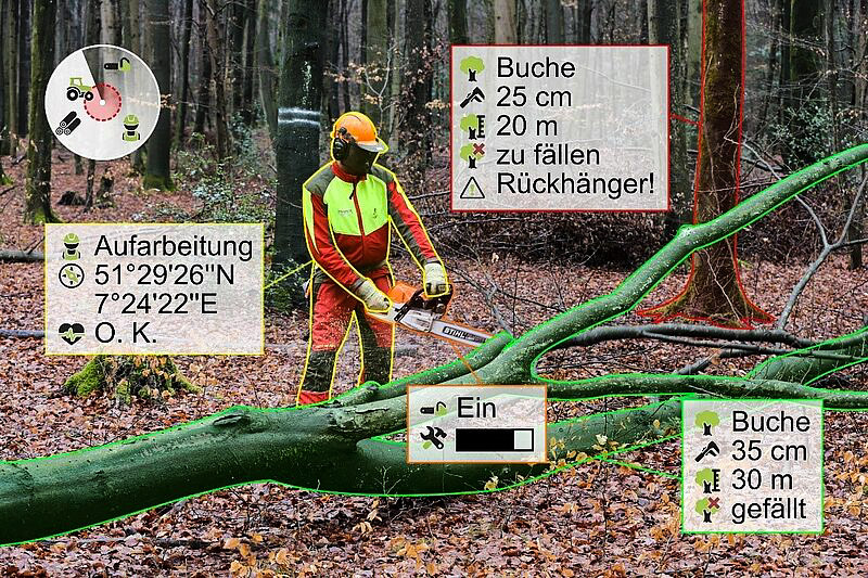
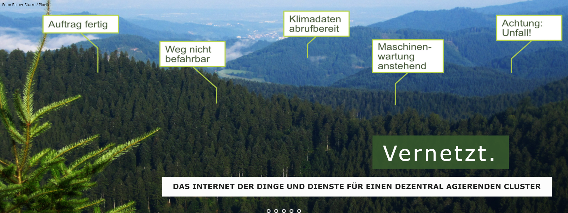
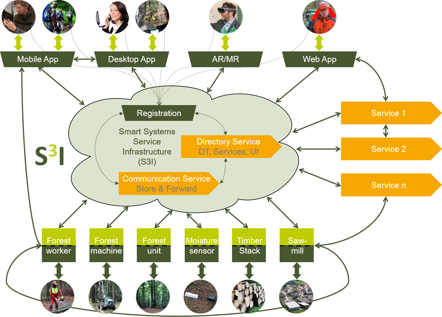
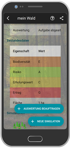
A very easy-to-use application has been created to make it user-friendly for everyone, with a basic variant for all audiences that is intuitive to use and a more advanced variant for technicians (the latter was accompanied by training).
Impatto economico
High at the scale of forest users, facilitates many processes linked to public forest services and lowers inventory costs for both public and private users.
Effetto sul lavoro
Difficult to specify
conoscenze specifiche necessarie
For the all public variant none, only knowledge of the location of the plot and internet access, for the technical variant knowledge of foresters and some rudiments of using the application.
I costi di attuazione

Free for users

Voting
0%
Inizio anno
2018
fine anno
2020
Breve descrizione
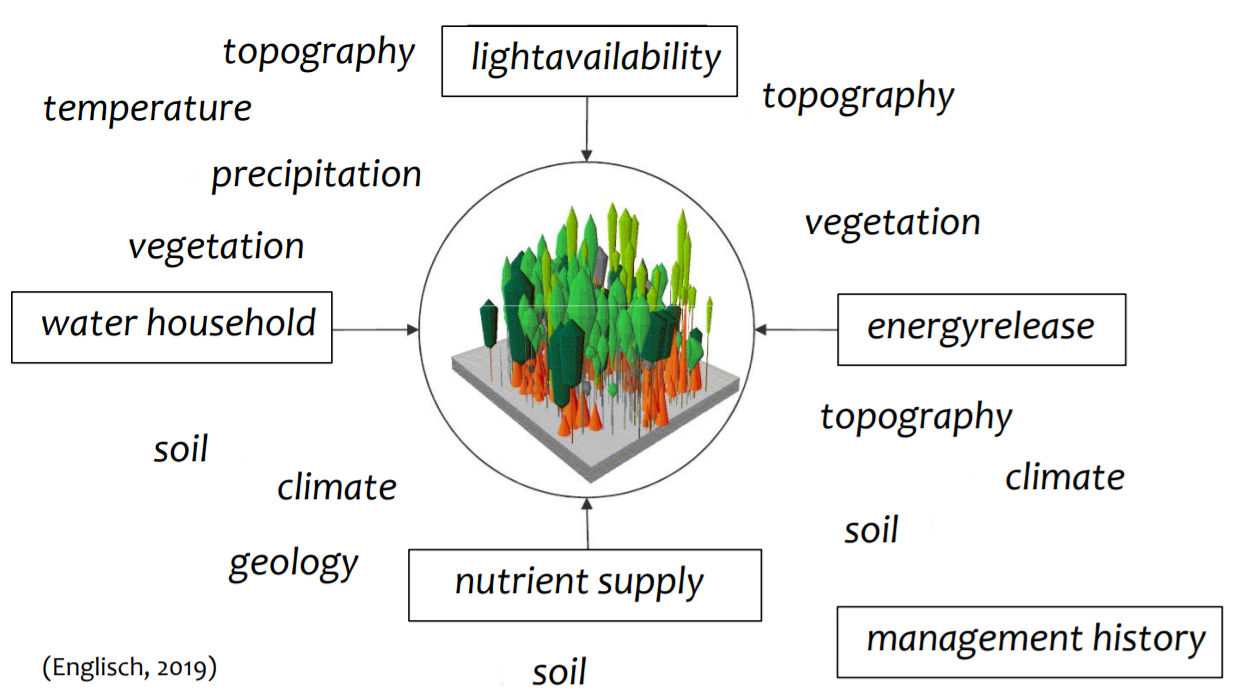
<p><span style="color: rgb(68, 68, 68); font-family: Calibri, sans-serif, &quot;Mongolian Baiti&quot;, &quot;Microsoft Yi Baiti&quot;, &quot;Javanese Text&quot;, &quot;Yu Gothic&quot;; font-size: 14.6667px; white-space: pre;">This project has created an updated cartography of the main forest species in La Rioja, collecting data such as the volume of wood, tree heights and vegetation structure for every 25x25m of land, with a very high level of resolution.</span></p>
soluzione digitale
Yes
Origine del legno
Abstract

The Forest-LidaRioja operational group has been formed with the aim of developing a forest inventory and a fuel model map of La Rioja using remote sensing technologies. Among the main practical utilities, we can highlight the importance for improving sustainable forest management, since with accurate and updated data, better decisions can be made and actions in forest areas can be better planned. This project has allowed the development of methodologies and processes for the integration of different sources of information (mainly airborne LiDAR from PNOA 2016 data and OPTICA satellite information). These methods are supported by the development of algorithms that correlate by statistical methods precise terrain data with LiDAR data, requiring the realization of very well calibrated forest plots and measurements located with sub-meter precision in strategic points for each forest species and working area.

The main results of the Forest-LidaRioja Project are:

  • Forest inventory of the forests of La Rioja.
  • Mapping of fuel models of the forest area of La Rioja to plan preventive forest fire prevention work.
  • Study of the evolution of poplar groves in the region and their supply potential.
  • Technical training on the products generated for professionals interested in their practical use. 

The products generated are open to the public so that anyone can download and use them.

Proprietario o organizzazione dell'autore
Agresta S. Coop.
Nome del proprietario o dell'autore
David García
Organizzazione di reporter
CESEFOR
Nome del reporter
Ángela García de Arana
E-mail del reporter
Progetto di riferimento
FEADER
Risorsa 1 titolo
Spatial Data Infrastructures of the Government of La Rioja (IDErioja)
Risorsa 2 documenti
Application for consulting and extracting data from specific plots of land
Immagine principale
Logo delle migliori pratiche
Logo della principale organizzazione
I costi di attuazione (Euro - €)
243000.00 €
Facilità di implementazione - Valutazione
Very easy
Hub
South-Western Hub
BP - Rosewood - V1
NO
potenziale sostenibilità - Valore
Very Positive
Paese d'origine
Spagna
Scala di applicazione
Progetto nell'ambito del quale questa scheda è stata creata
Rosewood Video
Guarda il video
Forest-LidaRioja
Ha un video
yes
Inglese
Innovazione
Yes
Proprietario o autore e-mail
potenziale di mobilitazione
Very positive
Tipo di legno in questione
All wood produced in the forest system (trunk, branches, roots).
potenziale sostenibilità
Improves forests resilience to wildfires, water scarcity, environmental degradation and other effects induced by climate change
Impatto sull'ambiente e la biodiversità
  • Demonstration and replication of a successful, innovative forest management scheme at a watershed scale. At the beginning it will be applied at sub catchment level in Spain (415 hectares), then at catchment level in Germany, Portugal and Spain (7,824 hectares) and finally it will be further expanded up to 350,000 hectares within five years from the project completion.
  • Reinforcement of mechanisms to develop climate change adaptation measures in rural areas and to ensure its socioeconomic sustainability;
  • Increased water reserves of 45-200 l/m²/year and increased water availability downstream, leading to a reduction in energy extraction costs to 5 W/hm;
  • Increased sustainable biomass production for bioenergy uses, between 10 and 15 t/ha year, including both forest and agricultural residues traditionally burned and usually the cause of wildfires.
  • Reduced fire hazards by 30%, protecting rural populations currently residing in risk areas
  • Increased resilience of 25% of forest areas to withstand droughts, pests and disease outbreak.
Id: 2593113
Continent Code: EU
Country Code: ES
Country Name: Spain
Name: Valencia
Facilità di implementazione
It is not easy to use, but we are developing user guides to make it easier.
Impatto economico
The tool is free, so the economic impact is positive as you provide a very powerful management tool at 0 cost.
Effetto sul lavoro
The management that is proposed always generates jobs to carry it out.
Effetto sul reddito
If the management objective is to maximise productivity, revenues will also be maximised.
conoscenze specifiche necessarie
Knowledge of Geographic Information Systems is necessary to be able to prepare the input data for the tool.
prerequisiti chiave

Input data for the chosen mechanistic model.

Decision variables.

Constraints to be applied.

Voting
0%
Inizio anno
2019
fine anno
2023
Breve descrizione
<p>C.A.F.E. determines the optimum silvicultural activities to manage multiple products, goods and services such as biomass production, C2 sequestration, fire risk, water provisioning , climatic resilience or biodiversity, for a selected solution.</p>
soluzione digitale
Yes
Origine del legno
potenziale di sfruttamento

High, as it is based on mechanistic modelling it can be applied in any climatic region. Furthermore, by including a wide range of ecosystem services, it can meet the needs of different types of forest management.

Abstract

This tool determines the optimum silvicultural activities to manage multiple products, goods and services such as biomass production, CO2 sequestration, fire risk, water provisioning, climatic resilience or biodiversity, which are simultaneously quantified in time and space for a selected solution. Main advantages include:

  • Changing the mono-objective approach in order to include a group of ecosystem goods and services.
  • Improving the economic performance of low productive areas by quantifying and valorising other resources that could be remunerated attending to the environmental value.
  • Holistic optimization of multiple goods and services out of forest management.
  • Adequacy to the specific characteristics of each site.
  • Multi-scalar results (plot, forest working unit, catchment, etc.).

C.A.F.E. is a tool that combines eco-hydrologic dynamic simulation with many-criteria optimization, where the user can carry out forest management according to more than one product at the same time, and choose the relevance of each objective/product. This software is capable of working under different climatic regions thanks to the previous calibration of the eco-hydrological simulation. Furthermore, it is possible to modify the spatial scale moving from plot to catchment, integrating a strong biophysical unit. In the same way, simulating different climatic scenarios is also possible. The result is a group of possible solutions among which forest manager can decide and apply.

Proprietario o organizzazione dell'autore
Technical University of Valencia
Nome del proprietario o dell'autore
María González Sanchis
Organizzazione di reporter
CESEFOR
Nome del reporter
Ángela García de Arana
E-mail del reporter
Progetto di riferimento
The project LIFE RESILIENT FORESTS – Coupling water, fire and climate resilience with biomass production from forestry to adapt watersheds to climate change is co-funded by the LIFE Programme of the European Union under contract number LIFE 17 CCA/ES/000063
Immagine principale
Logo delle migliori pratiche
Logo della principale organizzazione
Logo del progetto
Ulteriore visiva 1
Ulteriore visiva 2
Ulteriore visiva 3
Facilità di implementazione - Valutazione
Medium
Hub
South-Western Hub
Regione di origine
2593113
BP - Rosewood - V1
NO
potenziale sostenibilità - Valore
Very Positive
Paese d'origine
Belgio
Germania
Portogallo
Spagna
Titolo (denominazione nazionale)
LIFE RESILIENT FORESTS
Scala di applicazione
Progetto nell'ambito del quale questa scheda è stata creata
Ha un video
no
Norwegian Bokmål
Innovazione
No
Proprietario o autore e-mail
1 ° Dominio (principale)
Voting
0%
soluzione digitale
No
Abstract
Landskogtakseringen (LST) startet i 1919, utløst av bekymring og usikkerhet rundt skogens forhold.
Ordningen er basert på et nettverk av permanente prøveflater, fordelt i et nett over hele Norge - på både skogkledd og skogkledd mark. Prøveflatene måles på nytt med en rotasjon på fem år. På prøveflater som ligger på skogsmark eller andre landtyper med trær, måles alle trær som vokser innenfor en 250 m² areal med deres koordinater inkludert, og gjør det mulig å etablere tidsserier på tre nivå. I tillegg til stående volum, tilvekst og treslag måles en rekke parametere for å gi informasjon om f.eks. produktivitet, bestandsstruktur, skoghelse, skogsdriftsforhold og biologisk mangfold.
Dataene fungerer som et viktig grunnlag for nasjonal skogpolitisk utvikling og brukes av både statlige organer og annen offentlig forvaltning, så vel som av skogindustrien, forsknings- og undervisningsformål og nasjonal og internasjonal rapportering. Også utvikling og testing av applikasjoner for fjernmåling er et viktig forskningsfelt innen LST. Innholdet i taksten oppdateres jevnlig for å møte nye krav fra samfunnet. 
Proprietario o organizzazione dell'autore
Norwegian Institute of Bioeconomy Research (Nibio)
Nome del proprietario o dell'autore
Aksel Granhus
Organizzazione di reporter
Tretorget Ltd
Nome del reporter
Ola Rostad
E-mail del reporter
Immagine principale
BP - Rosewood - V1
NO
Paese d'origine
Norvegia
Titolo (denominazione nazionale)
Landskogtakseringen
Scala di applicazione
Progetto nell'ambito del quale questa scheda è stata creata
Ha un video
no
Polacco
Innovazione
Yes
Proprietario o autore e-mail
Voting
0%
Inizio anno
2015
fine anno
2018
Titolo (abbreviazione)
RemBioFor
Breve descrizione
Projekt B+R, którego celem było opracowanie kompleksowej metody określania wybranych cech taksacyjnych drzewostanów oraz ilości nadziemnej biomasy i związanego w niej węgla przy zastosowaniu danych teledetekcyjnych i nowoczesnych narzędzi ich przetwarzania
soluzione digitale
Yes
Abstract

Celem projektu było opracowanie kompleksowej metody określania wybranych cech taksacyjnych drzewostanów oraz nadziemnej biomasy i związanego w niej węgla przy zastosowaniu danych teledetekcyjnych dla planowania i zarządzania w leśnictwie. Zadania w projekcie obejmowały:

  • pozyskanie i przetworzenie danych terenowych oraz teledetekcyjnych,
  • opracowanie metody inwentaryzacji ilości biomasy drzew i związanego w nich węgla na podstawie danych radarowych,
  • opracowanie metody inwentaryzacji zapasu, biomasy i wybranych cech taksacyjnych drzewostanów na podstawie wybranych aktywnych metod teledetekcji,
  • opracowanie metody lokalnej korekty wzorów dendrometrycznych na podstawie danych pozyskanych za pomocą technologii naziemnego skanowania laserowego (TLS) oraz
  • opracowanie wzorów allometrycznych oraz wskaźników akumulacji biomasy (BEF) umożliwiających przeliczenie miąższości grubizny drzew na biomasę nadziemnej części drzew oraz wielkość związanego w nich węgla.

Rezultaty projektu są wdrażane w praktyce urządzeniowej w Polsce. Wdrożenie rezultatów projektów przyczynia się do skrócenia czasu i obniżenia kosztów prac urządzeniowych, w szczególności inwentaryzacji zasobów drzewnych, pozwalają na uzyskanie wysokiej jakości danych dotyczących bilansu CO2, zasobów biomasy i etatów cięć. Umożliwiają precyzyjne (do poziomu wydzielenia) określenie miąższości i cech taksacyjnych dla dowolnego obszaru leśnego.

Proprietario o organizzazione dell'autore
Instytut Badawczy Leśnictwa
Nome del proprietario o dell'autore
Krzysztof Stereńczak
Organizzazione di reporter
Łukasiewicz Research Network - Wood Technology Institute (ITD)
Nome del reporter
Dobrochna Augustyniak-Wysocka
Progetto di riferimento
Remote sensing based assessment of woody biomass and carbon storage in forests (REMBIOFOR), National Centre for Research and Development within the program „Natural environment, agriculture and forestry” BIOSTRATEG, agreement no. BIOSTRATEG1/267755/4/NCBR/2015
Risorsa 1 titolo
Projekt RemBioFor – prezentacja wstępnych założeń i celów projektu
Risorsa 2 documenti
Parkitna K., Krok G., Lisańczuk M., Mitelsztedt K., Ukalski K., Magnussen S., Markiewicz A., Miścicki S., Stereńczak K. 2021. Modelling growing stock volume of forest stands with the use of selected LiDAR Area Based Approaches in various predictive models. Forestry: An International Journal of Forest Research
Immagine principale
Didascalia dell'immagine principale
Prace terenowe: pomiar oraz pozyskanie biomasy drzewnej (sierpień - wrzesień 2015)
Logo delle migliori pratiche
Logo della principale organizzazione
Ulteriore visiva 1
Hub
Central-East Hub
BP - Rosewood - V1
NO
Paese d'origine
Polonia
Titolo (denominazione nazionale)
Teledetekcyjne określanie biomasy drzewnej i zasobów węgla w lasach
Scala di applicazione
Progetto nell'ambito del quale questa scheda è stata creata
Ha un video
no
Inglese
Innovazione
Yes
1 ° Dominio (principale)
Voting
0%
Titolo (abbreviazione)
GREEN FORESEEN
Breve descrizione
<table border="0" cellpadding="0" cellspacing="0" style="width:361px;" width="361"> <tbody> <tr height="95"> <td height="95" style="height:96px;width:361px;">Study the consumption of fuelwood by households in Greece<br /> and, by doing so, to lay down the foundations for the development of the first Greek Forest Sector Model (GFSM), which will<br /> be a partial-equilibrium model of the forest sector.&nbsp;</td> </tr> </tbody> </table>
soluzione digitale
Yes
Abstract

Design and carry out a
survey of the fuelwood market in Greece, as well as by analysing national statistics on energy consumption. This will give
insights on all aspects of fuelwood demand and supply and will allow for the characterisation of the illegal logging problem. It
will also assist in the development of the GFSM, as fuelwood constitutes over 65% of total timber production in the country.
The ultimate goal of the GFSM will be to enhance forest management by simulating impacts of policy and market changes
on the sector. An intentional byproduct of the GFSM will be the generation of knowledge that can be utilised by other
models, such as the EC's European Forest Information Scenario Model (EFISCEN).
Immagine principale
BP - Rosewood - V1
NO
Progetto nell'ambito del quale questa scheda è stata creata
Ha un video
no
Inglese
Innovazione
No
Proprietario o autore e-mail
1 ° Dominio (principale)
Voting
0%
Breve descrizione
<table border="0" cellpadding="0" cellspacing="0" style="width:359px;" width="358"> <tbody> <tr height="60"> <td height="60" style="height:60px;width:359px;">A systematic sample-based survey of the Norwegian forest, providing vital resource and environmental data for the whole country. It records information about growing stock and annual increment, and operating and environmental conditions.</td> </tr> </tbody> </table>
soluzione digitale
No
Abstract
The National Forest Inventory (NFI) started in 1919, triggered by concern and uncertainty about the conditions of the forests.
The scheme is based on a network of permanent sample plots, distributed in a grid across all of Norway – on both forested and unforested land. The plots are re-measured on a five-year rotation. On plots located on forest land or other land types with tree cover, all trees growing within a 250 m² plot are measured with their coordinates included, thus enabling time-series to be established at the tree level. In addition to stand volume, increment and tree species, a range of parameters are measured to provide information about e.g. site productivity, stand structure, forest health, forest operation conditions, and biological diversity.
The data serves as an important basis for national forest policy development and are used by both Governmental bodies and other public administration, as well as by the forest industry, research and teaching purposes, and national and international reporting. Also, development and testing of remote sensing applications is an important field of research within the NFI. The content of the inventory is regularly updated to meet new demands from the society.
Proprietario o organizzazione dell'autore
Norwegian Institute of Bioeconomy Research (Nibio)
Nome del proprietario o dell'autore
Aksel Granhus
Organizzazione di reporter
Tretorget Ltd
Nome del reporter
Ola Rostad
E-mail del reporter
Immagine principale
Hub
Northern Hub
BP - Rosewood - V1
NO
Paese d'origine
Norvegia
Titolo (denominazione nazionale)
Landskogtakseringen
Scala di applicazione
Progetto nell'ambito del quale questa scheda è stata creata
Ha un video
no
Inglese
Innovazione
Yes
Proprietario o autore e-mail
potenziale di mobilitazione
High, activation of forest owners to initiate forestry interventions is encouraged by the game character of the app.
potenziale sostenibilità
Sustainable forest management is encouraged based on individual objectives of the forest owners.
Impatto sull'ambiente e la biodiversità

Economic, ecological and social forest functions are integrated into the apps decision support system.

Facilità di implementazione
The solution is not yet available on the market.
Voting
0%
Breve descrizione
<table border="0" cellpadding="0" cellspacing="0" style="width:544px;" width="544"> <tbody> <tr height="60"> <td height="60" style="height:60px;width:544px;">Comparison of silvicultural treatment concepts by simulating forest growth processes on the smartphone.</td> </tr> </tbody> </table>
soluzione digitale
Yes
Abstract

In the iWald project, a system is being developed enabling forest owners to obtain realistic and technically sound options for the sustainable management of their forests. The individual objectives of the forest owner (private, communal, state) are taken into account as well as the forestry risk minimization and the sustainable conversion of forests while safeguarding the economic, ecological and social forest functions. One of the main results of iWald will be the "iWald App", which can be used to simulate forest growth processes on a smartphone. This will be provided with different entry barriers, so that both the forest layman and the trained forester will find their access to iWald. The goals include activating forest owners, who can thus approach their forest on a playful level, or improving public acceptance of forestry interventions through the possibility of simple visualization of future consequences.

Proprietario o organizzazione dell'autore
RWTH Aachen, Institute for Man-Machine Interaction
Nome del proprietario o dell'autore
Dr.Ing. Martin Hoppen
Organizzazione di reporter
FBZ
Nome del reporter
Dr. Marie-Charlotte Hoffmann
Progetto di riferimento
iWald, funded by FNR under no. 22012818
Immagine principale
Logo delle migliori pratiche
Logo della principale organizzazione
Ulteriore visiva 1
Facilità di implementazione - Valutazione
Difficult
Hub
Central-West Hub
BP - Rosewood - V1
NO
potenziale sostenibilità - Valore
Very Positive
Paese d'origine
Germania
Scala di applicazione
Progetto nell'ambito del quale questa scheda è stata creata
Ha un video
no