Forest inventory; resources; development

Inglés
Innovación
No
Correo electrónico del autor o propietario
Voting
0%
Descripción breve
<table border="0" cellpadding="0" cellspacing="0" style="width:359px;" width="358"> <tbody> <tr height="60"> <td height="60" style="height:60px;width:359px;">A systematic sample-based survey of the Norwegian forest, providing vital resource and environmental data for the whole country. It records information about growing stock and annual increment, and operating and environmental conditions.</td> </tr> </tbody> </table>
Solución digital
No
Resumen
The National Forest Inventory (NFI) started in 1919, triggered by concern and uncertainty about the conditions of the forests.
The scheme is based on a network of permanent sample plots, distributed in a grid across all of Norway – on both forested and unforested land. The plots are re-measured on a five-year rotation. On plots located on forest land or other land types with tree cover, all trees growing within a 250 m² plot are measured with their coordinates included, thus enabling time-series to be established at the tree level. In addition to stand volume, increment and tree species, a range of parameters are measured to provide information about e.g. site productivity, stand structure, forest health, forest operation conditions, and biological diversity.
The data serves as an important basis for national forest policy development and are used by both Governmental bodies and other public administration, as well as by the forest industry, research and teaching purposes, and national and international reporting. Also, development and testing of remote sensing applications is an important field of research within the NFI. The content of the inventory is regularly updated to meet new demands from the society.
Organización autora o propietaria de la buena práctica
Norwegian Institute of Bioeconomy Research (Nibio)
Nombre del autor o propietario
Aksel Granhus
Organización intermediaria de contacto
Tretorget Ltd
Persona de contacto del intermediario
Ola Rostad
Correo electrónico del intermediario
Imagen principal
Hub
Northern Hub
BP - Rosewood - V1
NO
País de origen
Noruega
Título (idioma nacional)
Landskogtakseringen
Escala de aplicación
Proyecto bajo el que se ha creado esta ficha
Tiene vídeo
no
Inglés
Innovación
Yes
Source of wood

Above and below ground woody biomass

Correo electrónico del autor o propietario
Código
IN_ES_05
Time scale
From 2018
Potencial de movilización
Unknown
Tipo de madera afectada
All kind of wood
Potencial de sostenibilidad
Very positive
Impacto en el medio ambiente y la biodiversidad

Positive

Facilidad de aplicación
Easy, basic digital skills
Conocimientos específicos necesarios
Very high skills and knowledge in remote sensing, forestry and software development
Costes de aplicación

300.000-1.000.000 €  

Nivel de preparación técnica
Immediately applicable
Prerequisitos clave

To know its existence

Localidad
Spain.
Implementers
Agresta S.Coop
Actual status
Running
Adjuntos
País Región Población
Spain
Ámbito
National
Voting
0%
Año de comienzo
2018
Descripción breve
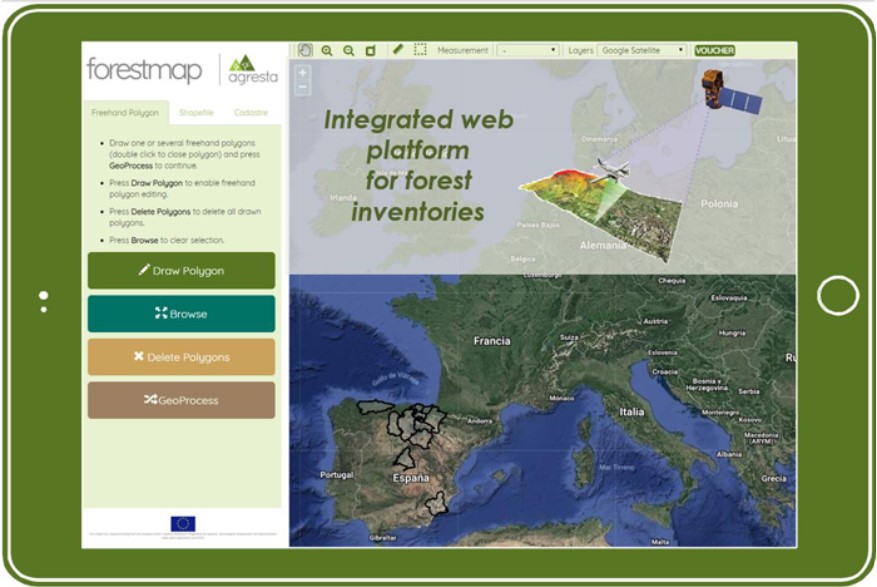
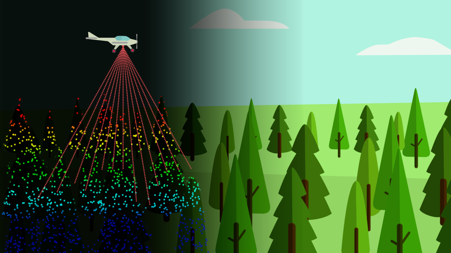
ForestMap is an e-commerce platform that allows users to make reliable and on-line forest inventories of a specific area in a rapid and simple way. It estimates all relevant variables included in a professional forest inventory through combination of pre-processed remote sensing data and powerful predictive models.
Solución digital
Yes
Resumen

ForestMap intuitive interface allows anyone to automatically generate forest inventories of a chosen area without the need of field work and unnecessary delays. ForestMap is an unprecedented solution that delivers accurate, quick and cost-effective forest inventory reports. It is necessary to integrate a maximum of information sources to generate the most accurate, complete and updated inventories possible: LiDAR, satellite, photogrammetry, available terrain data... Stakeholders in the forestry sector are not used to working with technological tools, so it is important to do important demonstration work and support.

ForestMap has a positive impact for a major mobilisation of wood resources allowing forest-owners, operators and indutries to assess stands in an easy and remote way. ForestMap is able to provide valuable reports on demand. An operative version of the web platform (link) is working for 10 provinces in Spain, that covers more than 3 M ha. ForestMap models showed a high performance in terms of accuracy (volume BIAS< 20%) and response times being able to produce a full inventory of less than 500ha in minutes.
ForestMap has been used to produce tailor-made products for specific uses and clients, based on innovation projects:

  • Tool for calculating (link)the amount of carbon in forest masses in the province of Bizkaia (Basque Country, Spain).
  • Inventory mapping of fuel models tool and for the prevention and management of forest fires in La Rioja
Organización autora o propietaria de la buena práctica
Agresta S. Coop.
Nombre del autor o propietario
David García
Imagen principal
Logo de la Buena Práctica
Logotipo de la organización principal
Visual adicional 1
Visual adicional 2
Hub
South-Western Hub
BP - Rosewood - V1
YES
País de origen
España
Escala de aplicación
Proyecto bajo el que se ha creado esta ficha
Rosewood Video
Ver vídeo
ForestMap (English clip)
Tiene vídeo
yes