Gestión forestal, silvicultura, servicios ecosistémicos, resiliencia

Inglés
Innovación
Yes
Correo electrónico del autor o propietario
Impacto en el medio ambiente y la biodiversidad
High impact, the portal Forestinfo.NRW is part of a bundle of policy measures  (climate adaptation strategy forest, silviculture concept, reforestation concept)
Facilidad de aplicación
public, free to use, intuitive and user-firendly
Voting
0%
Descripción breve
Interactive forest map for NRW with information on the type, condition, functions and use of the forest, and many aspects on climate change and adaptation.
Solución digital
Yes
Tipo de solución
Resumen

The internet portal provides insights into many aspects of North Rhine-Westphalia's forests via interactive, user-friendly maps. Forest ecology and management, forest nature conservation, recreational use, damage events, hazard prevention and other topics can be selected to search for specific information. How does climate change affect individual forest sites and which climate adaptation measures are suitable to preserve the functions of the forest as far as possible? The service provides comprehensive information on forest types, functions, management, and use, as well as climate change impacts on forest management. Climate adaptation measures are recommended to make forests more adaptable and resilient, including recommendation of appropriate tree species and mixed stands for different soil and climate conditions. As a comprehensive forest information system for the timber and forestry sector, the portal is aimed in particular at private forest owners and forest-owning municipalities and supports a wide range of evaluations and forestry planning. It is part of the climate adaptation strategy for forests in NRW and integrates databases of the state enterprise Wald und Holz NRW, the State Agency for Nature, Environment and Consumer Protection and the NRW Geological Survey. Relevant climate variables such as soil atmosphere (air temperature, precipitation); land surface (photosynthetic activity, land cover, biomass, forest fire, soil moisture) are integrated.

Organización autora o propietaria de la buena práctica
Ministry for the Environment, Agriculture, Nature Conservation and Consumer Protection of the State of North Rhine-Westphalia
Nombre del autor o propietario
Dr. Thorsten Mrosek
Organización intermediaria de contacto
FBZ
Persona de contacto del intermediario
Marie-Charlotte Hoffmann
Correo electrónico del intermediario
Título - Recurso 1
Waldinfo NRW
Título - Recurso 2
Forest management
Título - Recurso 3
Forest management in climate change
Imagen principal
BP - Rosewood - V1
NO
Título (idioma nacional)
Forestinfo.NRW
Proyecto bajo el que se ha creado esta ficha
Tiene vídeo
no
Inglés
Innovación
Yes
Correo electrónico del autor o propietario
Potencial de movilización
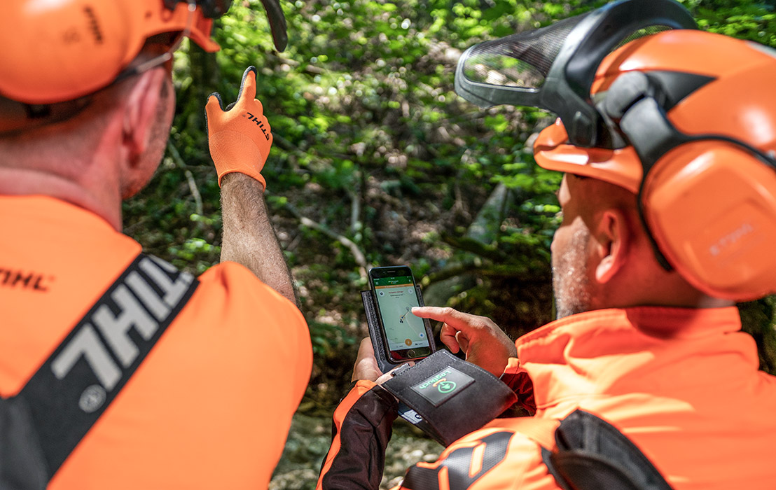
High, activation of forest owners to initiate forestry interventions is encouraged by the game character of the app.
Potencial de sostenibilidad
Sustainable forest management is encouraged based on individual objectives of the forest owners.
Impacto en el medio ambiente y la biodiversidad

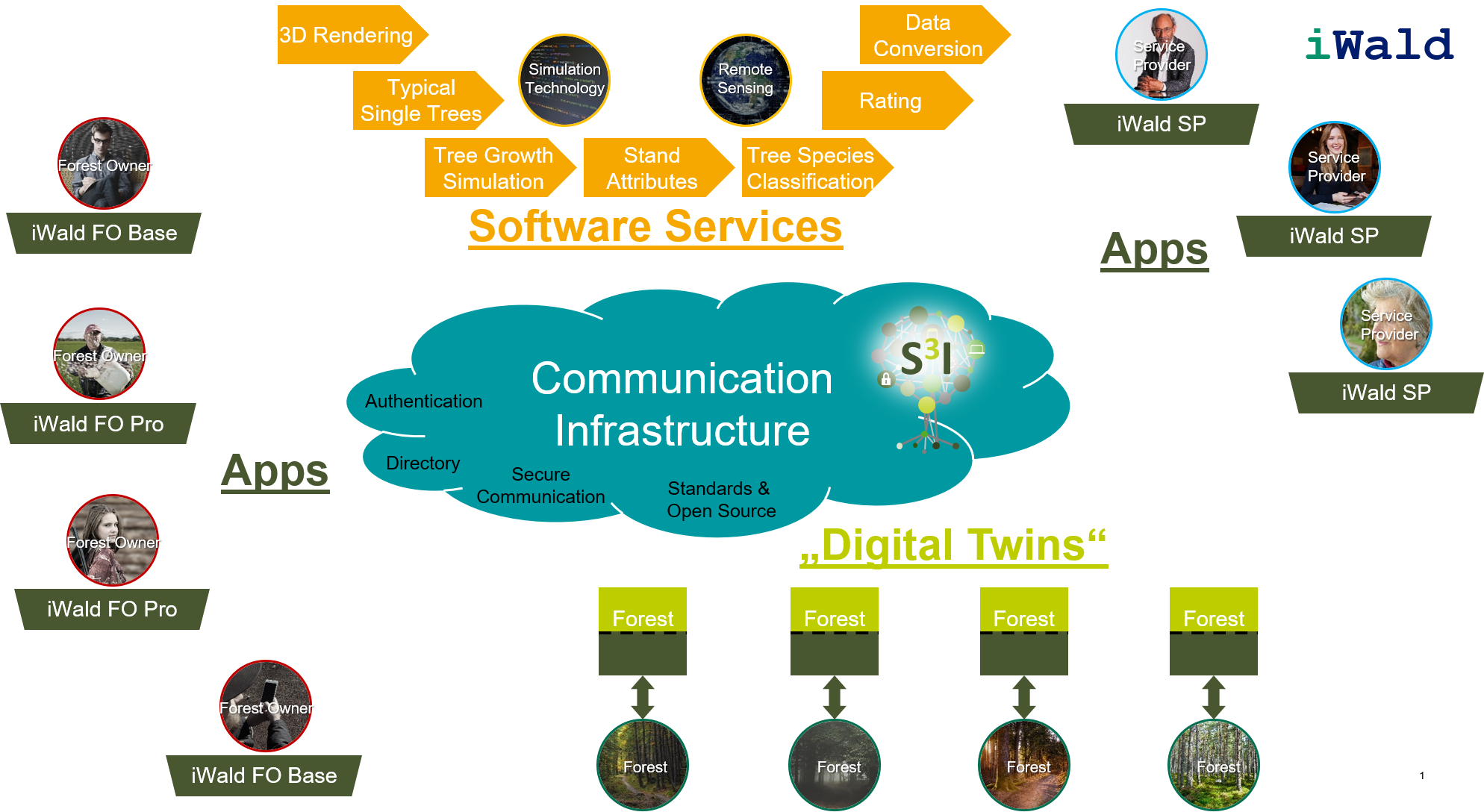
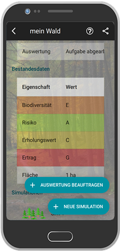
Economic, ecological and social forest functions are integrated into the apps decision support system.

Facilidad de aplicación
The solution is not yet available on the market.
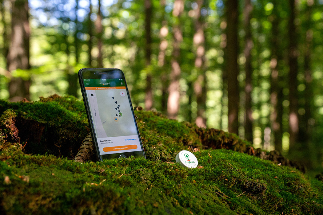
Voting
0%
Descripción breve
<table border="0" cellpadding="0" cellspacing="0" style="width:544px;" width="544"> <tbody> <tr height="60"> <td height="60" style="height:60px;width:544px;">Comparison of silvicultural treatment concepts by simulating forest growth processes on the smartphone.</td> </tr> </tbody> </table>
Solución digital
Yes
Resumen

In the iWald project, a system is being developed enabling forest owners to obtain realistic and technically sound options for the sustainable management of their forests. The individual objectives of the forest owner (private, communal, state) are taken into account as well as the forestry risk minimization and the sustainable conversion of forests while safeguarding the economic, ecological and social forest functions. One of the main results of iWald will be the "iWald App", which can be used to simulate forest growth processes on a smartphone. This will be provided with different entry barriers, so that both the forest layman and the trained forester will find their access to iWald. The goals include activating forest owners, who can thus approach their forest on a playful level, or improving public acceptance of forestry interventions through the possibility of simple visualization of future consequences.

Organización autora o propietaria de la buena práctica
RWTH Aachen, Institute for Man-Machine Interaction
Nombre del autor o propietario
Dr.Ing. Martin Hoppen
Organización intermediaria de contacto
FBZ
Persona de contacto del intermediario
Dr. Marie-Charlotte Hoffmann
Correo electrónico del intermediario
Referencia del proyecto
iWald, funded by FNR under no. 22012818
Imagen principal
Logo de la Buena Práctica
Logotipo de la organización principal
Visual adicional 1
Facilidad de implementación - Evaluación
Difficult
Hub
Central-West Hub
BP - Rosewood - V1
NO
Potencial de Sostenibilidad - Valor
Very Positive
País de origen
Alemania
Escala de aplicación
Proyecto bajo el que se ha creado esta ficha
Tiene vídeo
no
Inglés
Innovación
Yes
Correo electrónico del autor o propietario
Voting
0%
Descripción breve
<table border="0" cellpadding="0" cellspacing="0" style="width:601px;" width="601"> <tbody> <tr height="60"> <td height="60" style="height:60px;width:601px;">Mounted at the towing hitch, sensor values are collected and the road quality of unpaved, single lane roads gets assesd. Ultrasonic sensors (cross section scan of a road segment) acceleration sensors to assess the longitudinal roughness and a GPS sensor for locatiion.&nbsp;</td> </tr> </tbody> </table>
Solución digital
Yes
Resumen

Scanner is under constant development. A measuring device, mounted at the towing hitch of a car. Sensors collect values, to assess the road quality of unpaved, single lane roads. The system consists of ultrasonic sensors to scan the cross section of a road segment, acceleration sensors to get information about the longitudinal roughness and a GPS sensor for locating the information. After data collection, an open configurable software bundle (implemented as GUI modules in iFOS) allows individual settings for the single sensor thresholds and algorithms to adopt the system to the own road maintenance concept. Mounted at the car of the forest ranger an easy and frequent data collection is possible and provides an early and objective knowledge about the constructional decline of road segments. Maintenance costs can  be reduced and reconstruction measures get execute mor accurate.  A logical data interpretation of the sensor values is possible. The assignment of the sensors towards different decay expressions on the road surface was conducted and semi- automatically related to road quality segment classification. Results show, that a single manual optical assessment of road segments miss first phases of road decay and underlines the potential of such systems. Tests and calibrations of the road-scanner allows a good data interpretation for the set task. Many degrees of freedom of the scanner and the data interpretation still leaves some open research questions.

Organización autora o propietaria de la buena práctica
Thüringenforst
Nombre del autor o propietario
Sergej Chmara
Organización intermediaria de contacto
BFH Berne University of Applied Sciences
Persona de contacto del intermediario
Moritz Dreher
Correo electrónico del intermediario
Título - Recurso 1
FORMEC conference paper (2016)
Imagen principal
BP - Rosewood - V1
NO
País de origen
Alemania
Suiza
Título (idioma nacional)
Messlanze
Escala de aplicación
Proyecto bajo el que se ha creado esta ficha
Tiene vídeo
no
Inglés
Innovación
Yes
Correo electrónico del autor o propietario
Potencial de movilización
Better and more efficient planning of mechanized timber harvest supports wood mobilization through cost reduction.
Tipo de madera afectada
All types of wood
Potencial de sostenibilidad
Good planning decreases damages (e.g. soil damage on logging paths or forest roads).
Impacto en el medio ambiente y la biodiversidad

Decreased damages protect the forest soil as an important part of the forest ecosystem. Efficient planning also reduces fuel consumption.

Facilidad de aplicación
The solution is available on the market.
Impacto económico
Good planning reduces working time and fuel consumption, resulting in cost reductions for timber harvesting operators.
Efecto sobre el empleo
In light of aging workforces, digital solutions are expected to make forestry jobs more attractive to the next generation. The app helps to qualify staff.
Conocimientos específicos necesarios
Low / the manual is quite self-explanatory
Voting
0%
Año de comienzo
2017
Descripción breve
Digital solution for forestry data collection and networking of all actors in the timber process chain. Offline in the outdoor area, comfortable use thanks to voice recording and intuitive operation through a practice-oriented menu navigation in the mobile app and the web application.
Solución digital
Yes
Origen de la madera
Tipo de madera
Resumen

LogBuch enables data aggregation in the forest, a simple evaluation of the data and further processing.  The combination of voice recording and Bluetooth button enables hands-free precise location of trees with simultaneous recording of important information about the tree, such as safety instructions or planning working procedures. The expected cut volume can be determined, and assortments planned. Foresters and harvester operators both receive detailed information (cross-linking with third party systems is supported). Technology: An A 2-frequency GNSS-receiver is connected to a smartphone to estimate the current position. A bluetooth button is used for language analysis. All spoken information can be recorded, automatically transcribed and classified, and the actual position lodged. WLAN is used for data exchange between smartphone, webserver and other users. Data can be exported as a map or table in georeferenced or not referenced formats (xlsx, GeoJson, shp, GPX, map). Applications: Preparation of timber harvesting, establishment of a digital "inventory", area mapping (also planting) by connecting recorded corner points, mapping of skid trails by the line function (harvest control or certification basis), remote navigation via Google Maps. In addition, recording of habitat trees etc., support for hunting organization (high seats, driven hunt stands, stalking routes etc.) and traffic safety measures.

Organización autora o propietaria de la buena práctica
SDP Digitale Produkte GmbH - LogBuch
Nombre del autor o propietario
Friedrich Hollmeier
Organización intermediaria de contacto
FBZ
Persona de contacto del intermediario
Marie-Charlotte Hoffmann, Elke Hübner-Tennhoff
Correo electrónico del intermediario
Título - Recurso 1
Forstpraxis.de / Forest&Technology - "Please for dictation"
Título - Recurso 2
LogBuch - we digitalize the forest (video)
Imagen principal
Logo de la Buena Práctica
Visual adicional 1
Visual adicional 2
Visual adicional 3
Facilidad de implementación - Evaluación
Very easy
BP - Rosewood - V1
NO
Potencial de Sostenibilidad - Valor
Positive
País de origen
Alemania
Escala de aplicación
Proyecto bajo el que se ha creado esta ficha
Tipo de evento en el que se ha presentado esta IFS
Title of the event (Study visit - T2.3)
ROSEWOOD4.0 Study-Tour and Seminar: Digitalization – the virtual forest
Tiene vídeo
no
Inglés
Innovación
Yes
Correo electrónico del autor o propietario
Voting
0%
Descripción breve
<table border="0" cellpadding="0" cellspacing="0" style="width:527px;" width="527"> <tbody> <tr height="18"> <td height="18" style="height:19px;width:527px;">Single tree detection software uses drone data as the basis for estimating important tree parameters (tree position, height and diameter). Drones offer very precise terrain and inventory data and are very cost-effective.</td> </tr> </tbody> </table>
Solución digital
Yes
Resumen
Drone images are commonly used today as optical support in the forestry sector. The Potential of drone data and parameters that can be generated from single tree detection software is far from exhausted. The innovative and creative aspect of the project is to crate a digital twin of the forest. This twin provides all important tree parameters for the researchers to model the forest, make estimations of interventions, plan and make predictions.
Organización autora o propietaria de la buena práctica
BFH Berne University of Applied Sciences
Nombre del autor o propietario
Mark Günter
Organización intermediaria de contacto
BFH Bern University of Applied Sciences
Persona de contacto del intermediario
Moritz Dreher
Correo electrónico del intermediario
Imagen principal
BP - Rosewood - V1
NO
País de origen
Suiza
Título (idioma nacional)
Drohnen im Dienste der Forstwirtschaft
Escala de aplicación
Proyecto bajo el que se ha creado esta ficha
Tiene vídeo
no
Inglés
Innovación
Yes
Correo electrónico del autor o propietario
Voting
0%
Título (abreviación)
HeProMo
Descripción breve
HeProMo is an IT-based tool to predict the costs of timber harvesting scenarios under different aspects such as harvester logging. It allows certain settings to reflect the real situations in the forest. It provides preliminary costing and sensitivity analysis.
Solución digital
Yes
Resumen

HeProMo is an IT-based tool to predict the costs of timber harvesting scenarios under different aspects such as harvester logging. It allows certain settings to reflect the real situations in the forest. It provides preliminary costing and sensitivity analysis. estimation of productivity and cost for wood harvesting operations (preliminary costing). Writing and controlling offers for wood harvesting operations. Estimation of variables and their importance (sensitivity analysis). Well suitable for application in teaching , eductaion and research to identify key contributing factors and assessmen of their influence on the results. The productivity model (HeProMO) predicts quickly and with a good accurancy the costs for concrete timber harvestin scenarios. It allows the identification of optimization possibilities. The application is quite easy to handle and gives a solid basis for good economic choices.

Organización autora o propietaria de la buena práctica
Eidgenössische Forschungsanstalt WSl
Nombre del autor o propietario
Oliver Thess
Organización intermediaria de contacto
BFH Berne University of Applied Sciences
Persona de contacto del intermediario
Moritz Dreher
Correo electrónico del intermediario
Imagen principal
BP - Rosewood - V1
NO
País de origen
Suiza
Título (idioma nacional)
HeProMo
Escala de aplicación
Proyecto bajo el que se ha creado esta ficha
Tiene vídeo
no
Inglés
Innovación
Yes
Correo electrónico del autor o propietario
Voting
0%
Título (abreviación)
SiWaWa 2.0
Descripción breve
<table border="0" cellpadding="0" cellspacing="0" style="width:359px;" width="358"> <tbody> <tr height="60"> <td height="60" style="height:60px;width:359px;">A simple forest growth simulation model for practitioner (Android-App). SiWaWa needs only the number of the stems [N], the basal area per hectare [G] of a certain stand to generate separated the stem distribution curve according to the DBH-classes.</td> </tr> </tbody> </table>
Solución digital
Yes
Resumen
A simple forest growth simulation model for practitioner (Android-App). SiWaWa needs only the number of the stems [N], the basal area per hectare [G] of a certain stand to generate separated the stem distribution curve according to the DBH-classes. Free available Android-App, which could be used in the following fields:
1. Strategy: Goal dimension of the trees, cutting time
2. Care concept: Coordination of harvesting time, optimization of productivity
3. Measurements: Urgency and priority
4. Analysis: Starting point and forest development without interventions. Definition of intervention measures and simulation. SiWaWa 2.0 supports the decision makers in two aspects: Silvicultural and forest planning. It supports the foresters in a better understanding of the state point and forest development.
Organización autora o propietaria de la buena práctica
BFH Berne University of Applied Sciences
Nombre del autor o propietario
Christian Rosset
Organización intermediaria de contacto
BFH Bern University of Applied Sciences
Persona de contacto del intermediario
Moritz Dreher
Correo electrónico del intermediario
Imagen principal
Logotipo del proyecto
BP - Rosewood - V1
NO
País de origen
Suiza
Título (idioma nacional)
Waldwachstumssimulationsmodell
Escala de aplicación
Proyecto bajo el que se ha creado esta ficha
Tiene vídeo
no
Inglés
Innovación
Yes
Correo electrónico del autor o propietario
Voting
0%
Palabras clave
Título (abreviación)
MOTI
Descripción breve
<table border="0" cellpadding="0" cellspacing="0" style="width:568px;" width="568"> <tbody> <tr height="60"> <td height="60" style="height:60px;width:568px;">Forest stand inventory with the aid of the Smartphones capabilities (App). Easy, cheap and reliable tool for determining the most important dendrometer indicators (key figures of tree stands). Suitable for single tree measurement or stand inventories.</td> </tr> </tbody> </table>
Solución digital
Yes
Resumen
Forest stand inventory with the aid of the Smartphones capabilities (App). Easy, cheap and reliable tool for determining the most important dendrometer indicators (key figures of tree stands). Suitable for single tree measurement or stand inventories. Easy and fast implementation of forest inventories and single tree measurement.
Possible determination of the base area (m2/ha) with or without the distinction of different tree species. Trunk rate (#/ha), stand height (m/ha), reserve of rough wood (m3/ha). Smartphones can be used as a good referencing tool for forest inventories and forest operation planning. Many further application developments and integrations thinkable.
Organización autora o propietaria de la buena práctica
BFH Berne University of Applied Sciences
Nombre del autor o propietario
Christian Rosset
Organización intermediaria de contacto
BFH Bern University of Applied Sciences
Persona de contacto del intermediario
Moritz Dreher
Correo electrónico del intermediario
Imagen principal
BP - Rosewood - V1
NO
País de origen
Suiza
Título (idioma nacional)
MOTI
Escala de aplicación
Proyecto bajo el que se ha creado esta ficha
Tiene vídeo
no
Inglés
Innovación
Yes
Correo electrónico del autor o propietario
Voting
0%
Título (abreviación)
FINT-CH
Descripción breve
<table border="0" cellpadding="0" cellspacing="0" style="width:600px;" width="600"> <tbody> <tr height="60"> <td height="60" style="height:60px;width:600px;">In the project FINT-CH a methodology for the large-scale characterization of forest structures, thereon a better detection of single trees on the basis of remote sensing data, is under development. Top height, cover and mixture ratio get determined.&nbsp;</td> </tr> </tbody> </table>
Solución digital
Yes
Resumen
In the project FINT-CH a methodology for the large-scale characterization of forest structures, thereon a better detection of single trees on the basis of remote sensing data, is under development. By using segmentation, stand boundaries and the corresponding top height, cover and mixture ratio get determined. This forms the basis for the specific single tree detection using forest structures. Large-scale geodata with valuable forest information can be generated. Their usage in practice are demonstrated on the basis of four examples.Vector-geodata (type polygon) with stand boundaries and the following attributes:
- Basic shape (uniform, unequally)
- Top height (hdom)
- Cover ratio
- Mixture ratio
- Stem number of upper-class trees
- Basal area of upper-class trees                   Vector-geodata (type points) with detected single trees and the following attributes:
- Top height
- BHD
- Social status in the upper-class
-Z-trees

Vector-geodata (type polygon) with forest gaps, boundaries and aisle                                                  The methodology should be able to get a simple and large-scale investigation every 5 to 10 years regarding the mentioned data attributes mentioned beforehand. With these attributes conclusions are possible regarding stem numbers of different classes, protective forest investigations, mapping of forest gaps, boundaries and aisle as well as on stock estimations and finally operational planning (allowable cut, activity planning… )

Organización autora o propietaria de la buena práctica
BFH Bern University of Applied Sciences
Nombre del autor o propietario
Luuk Dorren
Organización intermediaria de contacto
BFH Berne University of Applied Sciences
Persona de contacto del intermediario
Moritz Dreher
Correo electrónico del intermediario
Imagen principal
BP - Rosewood - V1
NO
País de origen
Suiza
Título (idioma nacional)
Einzelbaumerkennung
Escala de aplicación
Proyecto bajo el que se ha creado esta ficha
Tiene vídeo
no
Inglés
Innovación
Yes
Correo electrónico del autor o propietario
Voting
0%
Año de comienzo
2021
Descripción breve
Qualification programme for forestry companies to build up management competences regarding newest economic and IT engineering procedures.
Solución digital
Yes
Resumen

The qualification course delivers a Certificate of Advanced Studies (CAS). It is a part-time professional training course designed for company managers and engineers to build up management competences regarding newest economic and engineering procedures and leadership activity competences regarding forestry operations and forestry administration. It amounts to 360 hours or 12 ECTS. Good feedback from former participants about usability of the professional education training.

Organización autora o propietaria de la buena práctica
BFH Bern University of Applied Sciences
Nombre del autor o propietario
Swantje Rahn
Organización intermediaria de contacto
BFH Berne University of Applied Sciences
Persona de contacto del intermediario
Moritz Dreher
Correo electrónico del intermediario
Imagen principal
Logotipo de la organización principal
BP - Rosewood - V1
NO
País de origen
Suiza
Título (idioma nacional)
CAS Waldmanagement und neue Technologien
Escala de aplicación
Proyecto bajo el que se ha creado esta ficha
Tiene vídeo
no