1.- Improve forest resilience and adaption to climate change

German
Innovation
Yes
Voting
0%
Start Year
2018
End Year
2021
Short description
<table border="0" cellpadding="0" cellspacing="0" style="width:573px;" width="573"> <tbody> <tr height="60"> <td height="60" style="height:60px;width:573px;">Das Fehlen von Standortskarten in der Steiermark bedingt einen neuen Ansatz bei der Standortserkundung und Kartierung der Waldstandorte. Daher soll eine Waldtypisierung auf Basis eines GIS-gestützten geoökologischen Stratifizierungsmodells erfolgen.</td> </tr> </tbody> </table>
Digital solution
Yes
Abstract

Das weitgehende Fehlen von Standortskarten in der Steiermark macht einen neuen Ansatz bei der Standortserkundung und Kartierung der vorkommenden Waldstandorte notwendig. Eine weitere wissenschaftliche Herausforderung stellt die Berücksichtigung von zukünftig veränderten Klimabedingungen dar, die sich auch auf die Klassifizierung von Standorten und Waldtypen auswirken wird. Für eine solcherart erforderliche „dynamische Standortsklassifizierung“ bestehen theoretische Konzepte, die konkrete Umsetzung einer integrierten Standorts- und Waldtypenklassifikation in einer realen Region wie der Steiermark stellt jedoch Neuland dar.
Im Rahmen des Projektes soll daher eine Waldtypisierung auf Basis eines GIS-gestützten geoökologischen Stratifizierungsmodells erfolgen. Als Datenbasis sollen das digitale Höhenmodell, eine geologische Basiskarte, digital vorliegende Standorts- und Klimadaten sowie neu zu erhebende Standortsparameter verwendet werden. Für die Waldtypenkarte sollen auf Grundlage der Punkt- und Flächendaten zunächst Themenkarten für die Faktoren Wärme, Wasser und Nährstoffhaushalt modelliert werden, die dann zu Waldtypen mit einheitlicher Faktorenkombination zusammengefasst werden. Das Modell erlaubt dann auf Basis der Datengrundlagen abgeleiteten digitalen geoökologischen Parametern (u.a. Höhenstufe, Hanglage, Substrat, Geländeform, Neigung) eine Stratifizierung der Waldtypen auf allen Hauptwaldstandorten. Jeder Waldtyp wird auf der Waldtypenkarte im Maßstab 1:25.000 dargestellt. Neben den ökologischen Fakten ist jeder Waldtyp mit einer waldbaulichen Beschreibung versehen, die Angaben zu den geeigneten Baumarten, Gefährdungen und möglichen Behandlungsvarianten in Hinblick auf den Klimawandel enthält. In dieser waldbaulichen Charakterisierung werden auch die bisherigen Erfahrungen mit den vorhanden Baumarten und ihren Mischungen getrennt nach Waldtypen beschrieben und Empfehlungen für die zukünftige Bestockung und deren Bewirtschaftung in Hinblick auf den Klimawandel gegeben.

Owner or author organization
BOKU - Universität für Bodenkultur Wien
Reporter organisation
Holzcluster Steiermark GmbH
Reporter name
DI Masa Jasarevic
Main picture
Logo of Main Organization
Additional visual 1
BP - Rosewood - V1
NO
Country of origin
Austria
Scale of application
Project under which this factsheet has been created
Rosewood Video
Watch video
FORSITE (Austria) - ROSEWOOD4.0 Best Practice & Innovation
Has video
yes
German
Owner or author e-mail
Voting
0%
Start Year
2016
Short description
<table border="0" cellpadding="0" cellspacing="0" style="width:443px;" width="442"> <tbody> <tr height="60"> <td height="60" style="height:60px;width:443px;">Die "FESTMETER Wöls GmbH"&nbsp; bietet Vitalitätsanalysen in Hinblick auf Borkenkäfererkennung im Nadelwald an.</td> </tr> </tbody> </table>
Digital solution
Yes
Abstract

Die „Festmeter Wöls GmbH“  bietet Vitalitätsanalysen in Hinblick auf Borkenkäfererkennung im Nadelwald an. Mit dem Trägersystemen Multikopter oder Leichtflugzeug werden Waldgrundstücke im Rastersystem überflogen und dabei mit einer Spezialkamera Luftbildaufnahmen gemacht, die später am Computer analysiert und ausgewertet werden. Durch die eingesetzte Technologie werden Vitalitätseinschränkungen sichtbar, man sieht Änderungen im Wassergehalt der Nadeln, nicht aber die genaue Ursache wie beispielsweise den Borkenkäfer selbst. Da aber Bildserien aus mindestens zwei zeitlich versetzten Flügen miteinander verglichen werden, können viele andere Ursachen wie Trockenstress ausgeschlossen werden, wodurch man dem Borkenkäfer sehr nahe auf die Spur kommt. In den Vitalitätsanalysen werden Initialbäume gezeigt wobei die Entscheidung über notwendige Maßnahmen erfolgt weiterhin durch das qualifizierte Vor-Ort Mitarbeiter.Eine 100%ige Trefferquote ist unmöglich. Das Ziel sollte sein, im Feld schneller und zielgerichteter agieren zu können. Langjährige Kunden berichten von positiven Trefferquoten von über 80 %.

Owner or author organization
Festmeter Wöls GmbH
Owner or Author name
Dr. Kurt Wöls
Reporter organisation
Holzcluster Steiermark GmbH
Reporter name
DI Masa Jasarevic
Main picture
Logo of Main Organization
Additional visual 1
BP - Rosewood - V1
NO
Country of origin
Austria
Title (national name)
Borkenkäfer-Erkennung
Scale of application
Project under which this factsheet has been created
Has video
no
English
Innovation
Yes
Owner or author e-mail
Mobilization Potential
Very positive
Kind of wood concerned
All wood produced in the forest system (trunk, branches, roots).
Sustainability Potential
Improves forests resilience to wildfires, water scarcity, environmental degradation and other effects induced by climate change
Impact on environment & biodiversity
  • Demonstration and replication of a successful, innovative forest management scheme at a watershed scale. At the beginning it will be applied at sub catchment level in Spain (415 hectares), then at catchment level in Germany, Portugal and Spain (7,824 hectares) and finally it will be further expanded up to 350,000 hectares within five years from the project completion.
  • Reinforcement of mechanisms to develop climate change adaptation measures in rural areas and to ensure its socioeconomic sustainability;
  • Increased water reserves of 45-200 l/m²/year and increased water availability downstream, leading to a reduction in energy extraction costs to 5 W/hm;
  • Increased sustainable biomass production for bioenergy uses, between 10 and 15 t/ha year, including both forest and agricultural residues traditionally burned and usually the cause of wildfires.
  • Reduced fire hazards by 30%, protecting rural populations currently residing in risk areas
  • Increased resilience of 25% of forest areas to withstand droughts, pests and disease outbreak.
Id: 2593113
Continent Code: EU
Country Code: ES
Country Name: Spain
Name: Valencia
Ease of implementation
It is not easy to use, but we are developing user guides to make it easier.
Economic impact
The tool is free, so the economic impact is positive as you provide a very powerful management tool at 0 cost.
Job effect
The management that is proposed always generates jobs to carry it out.
Income effect
If the management objective is to maximise productivity, revenues will also be maximised.
Specific knowledge needed
Knowledge of Geographic Information Systems is necessary to be able to prepare the input data for the tool.
Key prerequisites

Input data for the chosen mechanistic model.

Decision variables.

Constraints to be applied.

Voting
0%
Start Year
2019
End Year
2023
Short description
<p>C.A.F.E. determines the optimum silvicultural activities to manage multiple products, goods and services such as biomass production, C2 sequestration, fire risk, water provisioning , climatic resilience or biodiversity, for a selected solution.</p>
Digital solution
Yes
Origin of wood
Exploitation potential

High, as it is based on mechanistic modelling it can be applied in any climatic region. Furthermore, by including a wide range of ecosystem services, it can meet the needs of different types of forest management.

Abstract

This tool determines the optimum silvicultural activities to manage multiple products, goods and services such as biomass production, CO2 sequestration, fire risk, water provisioning, climatic resilience or biodiversity, which are simultaneously quantified in time and space for a selected solution. Main advantages include:

  • Changing the mono-objective approach in order to include a group of ecosystem goods and services.
  • Improving the economic performance of low productive areas by quantifying and valorising other resources that could be remunerated attending to the environmental value.
  • Holistic optimization of multiple goods and services out of forest management.
  • Adequacy to the specific characteristics of each site.
  • Multi-scalar results (plot, forest working unit, catchment, etc.).

C.A.F.E. is a tool that combines eco-hydrologic dynamic simulation with many-criteria optimization, where the user can carry out forest management according to more than one product at the same time, and choose the relevance of each objective/product. This software is capable of working under different climatic regions thanks to the previous calibration of the eco-hydrological simulation. Furthermore, it is possible to modify the spatial scale moving from plot to catchment, integrating a strong biophysical unit. In the same way, simulating different climatic scenarios is also possible. The result is a group of possible solutions among which forest manager can decide and apply.

Owner or author organization
Technical University of Valencia
Owner or Author name
María González Sanchis
Reporter organisation
CESEFOR
Reporter name
Ángela García de Arana
Project reference
The project LIFE RESILIENT FORESTS – Coupling water, fire and climate resilience with biomass production from forestry to adapt watersheds to climate change is co-funded by the LIFE Programme of the European Union under contract number LIFE 17 CCA/ES/000063
Main picture
Logo of Best Practice
Logo of Main Organization
Logo of Project
Additional visual 1
Additional visual 2
Additional visual 3
Ease of implementation - Evaluation
Medium
Hub
South-Western Hub
Region of origin
2593113
BP - Rosewood - V1
NO
Sustainability Potential - Value
Very Positive
Country of origin
Belgium
Germany
Portugal
Spain
Title (national name)
LIFE RESILIENT FORESTS
Scale of application
Project under which this factsheet has been created
Has video
no
Polish
Innovation
Yes
Owner or author e-mail
Voting
0%
Start Year
2018
End Year
2021
Short description
<table border="0" cellpadding="0" cellspacing="0" style="width:499px;" width="498"> <tbody> <tr height="104"> <td height="104" style="height:104px;width:499px;">Innowacyjny projekt B+R, którego celem jest zbudowanie systemu rozpoznawania zapachów (elektronicznego nosa) opartego na sensorach o dużej czułości oraz sztucznej inteligencji, służącego do monitorowania&nbsp; wybranych szkodników lasów.</td> </tr> </tbody> </table>
Digital solution
Yes
Origin of wood
Abstract

Postępujące zmiany klimatyczne oraz rozprzestrzenianie się nierodzimych gatunków są główną przyczyną rosnącego zagrożenia degradacji lasów spowodowanej przez różne patogeny i szkodniki. Jednocześnie, w związku z ograniczeniem stosowania środków chemicznych, zwiększa się znaczenie biologicznych metod ochrony i monitorowania drzewostanów. Głównym celem projektu jest rozwój innowacyjnego urządzenia (elektroniczny nos/e-NOS), opartego o szerokopasmowe czujniki elektrochemiczne i sieć neuronową, które wykrywa i analizuje sygnały zapachowe np. feromony wybranych gatunków owadów. Przykładami patogenów i szkodników branych pod uwagę przy rozwoju e-NOSa dla leśnictwa są Dendrolimus Pini (L.) and Phytophthora oomycetes.

Powstały system dostarcza kompleksowych i złożonych danych, które pozwalają na zbudowanie, za pomocą metod sztucznej inteligencji, klasyfikatora neuronów. Opracowane zostało oprogramowanie umożliwiające analizę danych i stworzenie bazy danych – biblioteki sygnałów, które umożliwiają wykrywanie poszukiwanych analitów w terenie. Dla każdej z aplikacji przewidzianej w projekcie (analizy specyficznych zapachów) stworzona została dedykowana matryca sensoryczna.

Owner or author organization
Politechnika Warszawska, Wydział Fizyki
Owner or Author name
Politechnika Warszawska, Wydział Fizyki
Reporter organisation
Łukasiewicz Research Network - Wood Technology Institute (ITD)
Reporter name
Dobrochna Augustyniak-Wysocka
Main picture
Logo of Best Practice
Hub
Central-East Hub
BP - Rosewood - V1
NO
Country of origin
Poland
Scale of application
Project under which this factsheet has been created
Has video
no
Polish
Innovation
Yes
Owner or author e-mail
Voting
0%
Start Year
2015
End Year
2018
Title (abbreviation)
RemBioFor
Short description
Projekt B+R, którego celem było opracowanie kompleksowej metody określania wybranych cech taksacyjnych drzewostanów oraz ilości nadziemnej biomasy i związanego w niej węgla przy zastosowaniu danych teledetekcyjnych i nowoczesnych narzędzi ich przetwarzania
Digital solution
Yes
Abstract

Celem projektu było opracowanie kompleksowej metody określania wybranych cech taksacyjnych drzewostanów oraz nadziemnej biomasy i związanego w niej węgla przy zastosowaniu danych teledetekcyjnych dla planowania i zarządzania w leśnictwie. Zadania w projekcie obejmowały:

  • pozyskanie i przetworzenie danych terenowych oraz teledetekcyjnych,
  • opracowanie metody inwentaryzacji ilości biomasy drzew i związanego w nich węgla na podstawie danych radarowych,
  • opracowanie metody inwentaryzacji zapasu, biomasy i wybranych cech taksacyjnych drzewostanów na podstawie wybranych aktywnych metod teledetekcji,
  • opracowanie metody lokalnej korekty wzorów dendrometrycznych na podstawie danych pozyskanych za pomocą technologii naziemnego skanowania laserowego (TLS) oraz
  • opracowanie wzorów allometrycznych oraz wskaźników akumulacji biomasy (BEF) umożliwiających przeliczenie miąższości grubizny drzew na biomasę nadziemnej części drzew oraz wielkość związanego w nich węgla.

Rezultaty projektu są wdrażane w praktyce urządzeniowej w Polsce. Wdrożenie rezultatów projektów przyczynia się do skrócenia czasu i obniżenia kosztów prac urządzeniowych, w szczególności inwentaryzacji zasobów drzewnych, pozwalają na uzyskanie wysokiej jakości danych dotyczących bilansu CO2, zasobów biomasy i etatów cięć. Umożliwiają precyzyjne (do poziomu wydzielenia) określenie miąższości i cech taksacyjnych dla dowolnego obszaru leśnego.

Owner or author organization
Instytut Badawczy Leśnictwa
Owner or Author name
Krzysztof Stereńczak
Reporter organisation
Łukasiewicz Research Network - Wood Technology Institute (ITD)
Reporter name
Dobrochna Augustyniak-Wysocka
Project reference
Remote sensing based assessment of woody biomass and carbon storage in forests (REMBIOFOR), National Centre for Research and Development within the program „Natural environment, agriculture and forestry” BIOSTRATEG, agreement no. BIOSTRATEG1/267755/4/NCBR/2015
Title - Resource 1
Projekt RemBioFor – prezentacja wstępnych założeń i celów projektu
Title - Resource 2
Parkitna K., Krok G., Lisańczuk M., Mitelsztedt K., Ukalski K., Magnussen S., Markiewicz A., Miścicki S., Stereńczak K. 2021. Modelling growing stock volume of forest stands with the use of selected LiDAR Area Based Approaches in various predictive models. Forestry: An International Journal of Forest Research
Main picture
Main picture caption
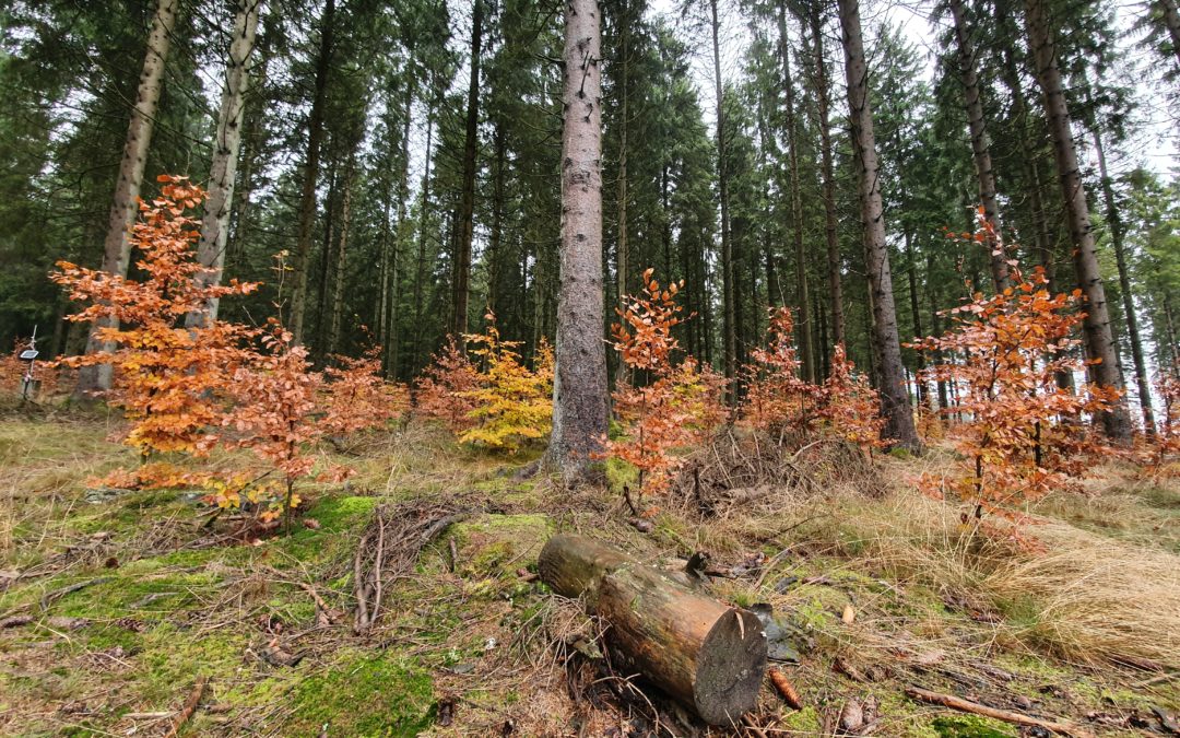
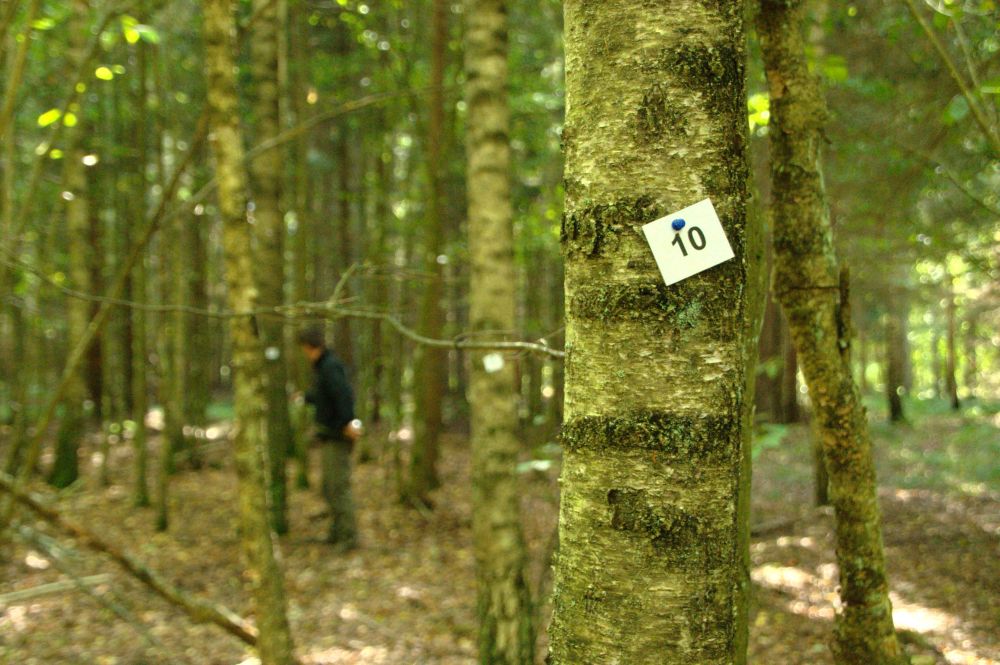
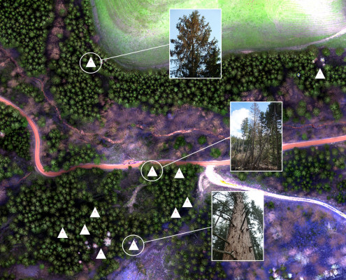
Prace terenowe: pomiar oraz pozyskanie biomasy drzewnej (sierpień - wrzesień 2015)
Logo of Best Practice
Logo of Main Organization
Additional visual 1
Hub
Central-East Hub
BP - Rosewood - V1
NO
Country of origin
Poland
Title (national name)
Teledetekcyjne określanie biomasy drzewnej i zasobów węgla w lasach
Scale of application
Project under which this factsheet has been created
Has video
no
English
Innovation
Yes
Owner or author e-mail
Voting
0%
Start Year
2018
Short description
<table border="0" cellpadding="0" cellspacing="0" style="width:348px;" width="348"> <tbody> <tr height="60"> <td height="60" style="height:60px;width:348px;">The "Melhor Eucalipto" project has the objective of communicating and sharing the best silvicultural practices for eucalyptus carried out by the pulp and paper industries and help improving management.&nbsp;</td> </tr> </tbody> </table>
Digital solution
No
Abstract

In 2015, eucalypt became the predominant tree species in Portugal and despite located in productive areas is often under insufficient/deficient management. The "Melhor Eucalipto" project, developed by CELPA, to promote good management practices for eucalypt stands through the organization of free roving Info Sessions to non-industrial private owners and the production of videos (~20) (www.celpa.pt/melhoreucalipto/category/videos/) and printable leaflets (~10) to be distributed or downloaded from the site (http://www.celpa.pt/melhoreucalipto/flyers/). To emphasize the impact of good management, the project comprises two side-by-side demonstration areas continuously monitored: one following the current management practiced by non-industrial forest owners and the other following the best recommend practices. The project also integrates an operational extension, the Limpa e Aduba Program (PLA), which offers landowners who apply technical support and the fertilization of their eucalyptus plantations, if they meet the eligibility criteria. In return, the owners are obliged to manage fuels and/or correct stand densities, in order to reduce the risk of fire, increase productivity and income, while promoting forest management and certification. At the end of the 3rd PLA campaign, about 3,800 owners have already benefited, corresponding to an area of 33,100 ha, mostly in smallholding plots.

Owner or author organization
CELPA – Pulp and paper Industries association
Owner or Author name
António Sousa Macedo
Reporter organisation
Instituto Superior de Agronomia (ISA)
Reporter name
Susana Barreiro
Reporter e-mail
Project reference
PDR 2020 (Programa de Desenvolvimento Rural do Continente 2014-2020)
Main picture
Logo of Main Organization
Logo of Project
Additional visual 1
Additional visual 2
Additional visual 3
BP - Rosewood - V1
NO
Country of origin
Portugal
Scale of application
Project under which this factsheet has been created
Has video
no
English
Innovation
Yes
Owner or author e-mail
Voting
0%
Start Year
2017
End Year
2020
Title (abbreviation)
e-globulus
Short description
<table border="0" cellpadding="0" cellspacing="0" style="width:527px;" width="527"> <tbody> <tr height="60"> <td height="60" style="height:60px;width:527px;">Knowledge transfer platform for assisting forest owners in eucalypt' stands management</td> </tr> </tbody> </table>
Digital solution
Yes
Abstract

The project aimed at technical and scientific knowledge transfer encouraging the management of eucalypt plantations. A freely available user-friendly platform providing site specific prescriptions concerning the best silvicultural practices that takes edaphic, climatic and topographic characteristics into account was developed. In order to benefit from technical assistance, the forest owner has to be registered in the platform (trial-version available). First, he has to add his property by drawing it directly on Google Maps or importing a shapefile/KML. The next step will consist of property/forest characterization (e.g. age and stand rotation, soil details, topography). Finally, has to specify if he wants to establish a new stand or maintain an existing one. After completed, a personalized technical prescription is immediately provided. The user can edit his list of properties or update the forests’ characteristics. When features are updated, the user can request for a revised technical prescription. A pdf file with the prescription can be downloaded or access can be directly granted to someone (e.g. forest manager). An additional feature allows users to consult possible restrictions of legal and/or environmental scope concerning forestry practices. This tool includes also an online library and other contents. By the end of 2021, the platform reached more than 43k visualizations, 10k users with 560 users registered in technical indications module; 3 patents were submitted.

Owner or author organization
RAIZ – Instituto de investigação da floresta e papel
Reporter organisation
Instituto Superior de Agronomia (ISA)
Reporter name
Susana Barreiro
Reporter e-mail
Main picture
Logo of Best Practice
Logo of Main Organization
Additional visual 1
Additional visual 2
BP - Rosewood - V1
NO
Country of origin
Portugal
Title (national name)
e-globulus | Plataforma de apoio técnico-científico à gestão de povoamentos de eucalipto
Scale of application
Project under which this factsheet has been created
Has video
yes
English
Innovation
Yes
Owner or author e-mail
Voting
0%
Short description
<table border="0" cellpadding="0" cellspacing="0" style="width:551px;" width="551"> <tbody> <tr height="60"> <td height="60" style="height:60px;width:551px;">Precision forestry service that with the help of RGB and multispectral images from drones, airplanes, helicopters or satellites can detect bark beetle infected or&nbsp;stressed trees.</td> </tr> </tbody> </table>
Digital solution
Yes
Abstract

Today, the technology for identifying bark beetle attacks in the forest is largely based on manual work through visual checks of forest areas, where early attacks are almost impossible to see, while old attacks are easier to detect. Attempts have been made to identify damage attacks using satellite radar maps which give a good indication and can be seen as a complementing part to our precision analysis. Arboair Forest Mapper is a service where you analyze your images via our AI. Our model is trained on over 200 000 trees and it is verified by forest managers.

Owner or author organization
Paper Province
Owner or Author name
Marcus Drugge
Reporter organisation
Paper Province
Reporter name
Gunnar Hellerström
Main picture
Arboair forest aerial view
Logo of Main Organization
Arboair logo
BP - Rosewood - V1
NO
Country of origin
Sweden
Title (national name)
Arboair AB
Scale of application
Project under which this factsheet has been created
Rosewood Video
Has video
yes
English
Innovation
Yes
Owner or author e-mail
Mobilization Potential
High, activation of forest owners to initiate forestry interventions is encouraged by the game character of the app.
Sustainability Potential
Sustainable forest management is encouraged based on individual objectives of the forest owners.
Impact on environment & biodiversity

Economic, ecological and social forest functions are integrated into the apps decision support system.

Ease of implementation
The solution is not yet available on the market.
Voting
0%
Short description
<table border="0" cellpadding="0" cellspacing="0" style="width:544px;" width="544"> <tbody> <tr height="60"> <td height="60" style="height:60px;width:544px;">Comparison of silvicultural treatment concepts by simulating forest growth processes on the smartphone.</td> </tr> </tbody> </table>
Digital solution
Yes
Abstract

In the iWald project, a system is being developed enabling forest owners to obtain realistic and technically sound options for the sustainable management of their forests. The individual objectives of the forest owner (private, communal, state) are taken into account as well as the forestry risk minimization and the sustainable conversion of forests while safeguarding the economic, ecological and social forest functions. One of the main results of iWald will be the "iWald App", which can be used to simulate forest growth processes on a smartphone. This will be provided with different entry barriers, so that both the forest layman and the trained forester will find their access to iWald. The goals include activating forest owners, who can thus approach their forest on a playful level, or improving public acceptance of forestry interventions through the possibility of simple visualization of future consequences.

Owner or author organization
RWTH Aachen, Institute for Man-Machine Interaction
Owner or Author name
Dr.Ing. Martin Hoppen
Reporter organisation
FBZ
Reporter name
Dr. Marie-Charlotte Hoffmann
Project reference
iWald, funded by FNR under no. 22012818
Main picture
Logo of Best Practice
Logo of Main Organization
Additional visual 1
Ease of implementation - Evaluation
Difficult
Hub
Central-West Hub
BP - Rosewood - V1
NO
Sustainability Potential - Value
Very Positive
Country of origin
Germany
Scale of application
Project under which this factsheet has been created
Has video
no
English
Owner or author e-mail
Voting
0%
Short description
<table border="0" cellpadding="0" cellspacing="0" style="width:516px;" width="516"> <tbody> <tr height="60"> <td height="60" style="height:60px;width:516px;">FESTMETER Wöls Ltd. offers vitality analyses with a focus on bark beetle detection in coniferous forests.</td> </tr> </tbody> </table>
Digital solution
Yes
Abstract

Festmeter Wöls Ltd. offers vitality analyses with regard to bark beetle detection in coniferous forests. Using the carrier systems multicopter or light aircraft, forest plots are flown over in a grid system and aerial photographs are taken with a special camera, which are later analysed and evaluated on the computer. The technology used makes vitality restrictions visible, changes in the water content of the needles can be seen, but not the exact cause, such as the bark beetle itself. However, since image series from at least two flights at different times are compared, many other causes such as drought stress can be excluded and the bark beetle can be traced very closely.  Initial trees are identified in the analysis, while the decision on necessary measures remains with the qualified on-site staff. A 100% hit rate is impossible. The aim should be to be able to act faster and more purposefully in the field. Long-standing customers report positive hit rates of over 80%. 

Owner or author organization
Festmeter Wöls GmbH
Owner or Author name
Dr. Kurt Wöls
Reporter organisation
Holzcluster Steiermark GmbH
Reporter name
DI Masa Jasarevic
Main picture
Logo of Main Organization
Additional visual 1
BP - Rosewood - V1
NO
Country of origin
Austria
Title (national name)
Borkenkäfer-Erkennung
Scale of application
Project under which this factsheet has been created
Has video
no