Beratungs- und Servicetools für Waldbesitzer

×

Fehlermeldung

  • Notice: Undefined index: #markup in bootstrap_preprocess_field() (Zeile 92 von /data/www/rosewood.admin.v4/sites/all/themes/bootstrap/template.php).
  • Notice: Undefined index: #markup in bootstrap_preprocess_field() (Zeile 92 von /data/www/rosewood.admin.v4/sites/all/themes/bootstrap/template.php).
Englisch
Innovation
Yes
E-Mail des Eigentümers oder Autors
Voting
0%
Titel (Abkürzung)
SAT4EST
Kurze Beschreibung
<table border="0" cellpadding="0" cellspacing="0" style="width:499px;" width="499"> <tbody> <tr height="60"> <td height="60" style="height:60px;width:499px;">An R&D project aimed at developing a simple, intuitive and cost-effective web-based service to support forest management supervision, integrating remote sensing satellite data with data acquired from other sources.</td> </tr> </tbody> </table>
Digitale Lösung
Yes
Zusammenfassung

The system consists of four components:

  • remote sensing data - quick access to current and historical data, enabling the user to compare satellite images from different periods;
  • complementary data - cadastral data and detailed forest inventory data from management plans (FMP);
  • remote sensing data products - geometric layers resulting from the processing of satellite images, showing the condition and health status of vegetation and forests;
  • geospatial analyses - juxtaposition of remote sensing data products with cadastral data and detailed forest inventory data, enabling to identify inconsistencies between the actual state of the forest and the state recorded in databases, as well as recent changes.

The entire solution is based on an intuitive map portal for users, which is used to generate various types of maps, including maps of forests and tree cover, forest changes, maps of forest types, maps of forest condition, maps of crown density, maps of aboveground forest biomass and the extent of stand damage due to windstorms, fires, floods and insect infestations. Users of the system have access to current and archival satellite images, and they can compare different types of maps with complementary data as well as upload their own data sets.

Eigentümer oder Autorenorganisation
Taxus IT Sp. z o.o.
Name des Eigentümers oder Autors
Sylwester Kulik
Organisation der Reporter
Łukasiewicz Research Network - Wood Technology Institute (ITD)
Name des Reporters
Dobrochna Augustyniak-Wysocka
Projekt-Referenz
Earth observation based service supporting local administration in non-state forest management (SAT4EST), funded by European Space Agency (ESA) through the Polish Incentive Scheme Programme
Hauptbild
Logo der Best Practice
Nabe
Central-East Hub
BP - Rosewood - V1
NO
Herkunftsland
Polen
Titel (nationaler Name)
[PL] System wspierający lokalną administrację w zarządzaniu lasami niepaństwowymi
Umfang der Anwendung
Projekt, in dessen Rahmen dieses Factsheet erstellt wurde
Hat Video
no
Englisch
Innovation
Yes
Source of wood

Above and below ground woody biomass

E-Mail des Eigentümers oder Autors
Code
IN_ES_05
Time scale
From 2018
Mobilisierungspotenzial
Unknown
Art des betroffenen Holzes
All kind of wood
Potenzial für Nachhaltigkeit
Very positive
Auswirkungen auf Umwelt und Biodiversität

Positive

Leichte Implementierung
Easy, basic digital skills
Spezifisches Wissen erforderlich
Very high skills and knowledge in remote sensing, forestry and software development
Kosten der Implementierung

300.000-1.000.000 €  

Technical readiness level
Immediately applicable
Wichtige Voraussetzungen

To know its existence

Location
Spain.
Implementers
Agresta S.Coop
Actual status
Running
Anhänge
Country Region City
Spain
Scope
National
Voting
0%
Startjahr
2018
Kurze Beschreibung
ForestMap is an e-commerce platform that allows users to make reliable and on-line forest inventories of a specific area in a rapid and simple way. It estimates all relevant variables included in a professional forest inventory through combination of pre-processed remote sensing data and powerful predictive models.
Digitale Lösung
Yes
Zusammenfassung

ForestMap intuitive interface allows anyone to automatically generate forest inventories of a chosen area without the need of field work and unnecessary delays. ForestMap is an unprecedented solution that delivers accurate, quick and cost-effective forest inventory reports. It is necessary to integrate a maximum of information sources to generate the most accurate, complete and updated inventories possible: LiDAR, satellite, photogrammetry, available terrain data... Stakeholders in the forestry sector are not used to working with technological tools, so it is important to do important demonstration work and support.

ForestMap has a positive impact for a major mobilisation of wood resources allowing forest-owners, operators and indutries to assess stands in an easy and remote way. ForestMap is able to provide valuable reports on demand. An operative version of the web platform (link) is working for 10 provinces in Spain, that covers more than 3 M ha. ForestMap models showed a high performance in terms of accuracy (volume BIAS< 20%) and response times being able to produce a full inventory of less than 500ha in minutes.
ForestMap has been used to produce tailor-made products for specific uses and clients, based on innovation projects:

  • Tool for calculating (link)the amount of carbon in forest masses in the province of Bizkaia (Basque Country, Spain).
  • Inventory mapping of fuel models tool and for the prevention and management of forest fires in La Rioja
Eigentümer oder Autorenorganisation
Agresta S. Coop.
Name des Eigentümers oder Autors
David García
Hauptbild
Logo der Best Practice
Logo der Hauptorganisation
Zusätzliches Bildmaterial 1
Zusätzliches Bildmaterial 2
Nabe
South-Western Hub
BP - Rosewood - V1
YES
Herkunftsland
Spanien
Umfang der Anwendung
Projekt, in dessen Rahmen dieses Factsheet erstellt wurde
Rosewood Video
Video ansehen
ForestMap (English clip)
Hat Video
yes
Englisch
Innovation
No
Source of wood

Depending on user

E-Mail des Eigentümers oder Autors
Code
BP_BW_12
Time scale
Development ongoing
Mobilisierungspotenzial
High / app can be used anywhere in the forest
Art des betroffenen Holzes
Depending on user
Potenzial für Nachhaltigkeit
Positive
Auswirkungen auf Umwelt und Biodiversität

Positive

Leichte Implementierung
Easy
Wirtschaftliche Auswirkungen
Positive / reduces workload for forest rangers
Arbeitsplatzeffekt
N.A.
Einkommenseffekt
Positive
Spezifisches Wissen erforderlich
Dealing with smartphone
Kosten der Implementierung

N.A.

Technical readiness level
Applicable
Wichtige Voraussetzungen

Technological assistance
The app is available for free on Google Playstore

Location
Germany
Implementers
rBITech UG
Actual status
Completed, but continuously improved
Anhänge
Country Region City
Germany
Scope
National
Voting
0%
Digitale Lösung
Yes
Zusammenfassung

The ForestManager is an app that serves as a reminder in the management of forestland. Green areas and forests can be managed and documented with the support of GPS data. These functions offer the possibility to document observations, to take pictures, to print them, to send and to export them for further use. Moreover, it allows a comparison of historical and current data and can detect changes in the environment.

Technological assistance for the efficient management of forest areas.

Hauptbild
Logo der Hauptorganisation
Logo des Projekts
BP - Rosewood - V1
YES
Herkunftsland
Deutschland
Umfang der Anwendung
Projekt, in dessen Rahmen dieses Factsheet erstellt wurde
Hat Video
no
Englisch
Innovation
Yes
Source of wood

Stemwood

E-Mail des Eigentümers oder Autors
Code
IN_FR_08
Time scale
Since 2009
Leichte Implementierung
Very easy: telephone survey to owners using cadastral information
Technical readiness level
Applicable
Location
France
Implementers
Private forest owners
Actual status
Running
Country Region City
France
Scope
National
Voting
0%
Startjahr
2009
Kurze Beschreibung
RESOFOP (Observation Network for the Private Forest economy) is a national network that conducts surveys for forest owners, to get a refined knowledge on how they perceive their forest as well as the issue of climate change. The objective is also to identify what can be done to better adapt forest management to the changing climate. A national report is published each year.
Digitale Lösung
No
Zusammenfassung

Private foresters had a lot of quantitative data thanks to the data accumulated by the National Forest Inventory for more than 20 years, as well as information on the structure of the private forest thanks to the Ministry of Agriculture's survey in 1999. But they did not take into account the behaviour of forest owners. In 2009, the network for observing the behaviour of forest owners was launched by the CNPF and Fransylva, with the financial support of France Bois Forêt. The objective is to collect new information on the behaviour of forest owners, particularly regarding the management of their forests according to their forest area and the region where they live. In the surveys, the same behavioural trends of forest owners appear: sentimental attachment to their wood, environmental responsibility, heritage to be valued and source of economic income.

The main outcomes include so far:

  • Surveys carried out by telephone to owners of more than 4ha of wood cadastral land with a duration of 15min
  • 2500 people interviewed throughout France during the surveys
  • Other surveys for specific studies at a more regional level (risk perception, climate change,...).  
  • The results of the surveys make it possible to create new management tools for forest owners and new distribution media. They are also used to improve the advice of technicians in order to better take into account the expectations of forest owners and encourage them to mobilize their wood.
Eigentümer oder Autorenorganisation
CNPF-IDF
Name des Eigentümers oder Autors
Julie Thomas
Organisation der Reporter
CRPF Nouvelle-Aquitaine
Name des Reporters
Henri Husson
E-Mail des Reporters
Titel der Ressource 1
Resofop in 10 assets
Ressource 1 Datei-Upload
Hauptbild
BP - Rosewood - V1
YES
Herkunftsland
Frankreich
Umfang der Anwendung
Projekt, in dessen Rahmen dieses Factsheet erstellt wurde
Hat Video
no
Englisch
Source of wood

Stemwood, woody biomas

E-Mail des Eigentümers oder Autors
Code
BP_SLO_04
Time scale
2017 -
Technical readiness level
Running
Location
Slovenia
Implementers
Slovenian Forestry institute
Actual status
Running
Country Region City
Slovenia
Scope
National
Voting
66.7%
Startjahr
2017
Kurze Beschreibung
The web portal Moj Gozdar is intended for finding suitable contractors for forestry services.
Digitale Lösung
Yes
Zusammenfassung

The significant increase in the number of forestry contractors in last few years has been increasing competition, however at the same time requires a reflection on the objective quality of contractors. In sustainable management of forests, the criterion for the selection of contractor should not be only the lowest service price, but it should include also environmental, social and business aspects of the relationship between the client and the contractor. Platform MojGozdar (MyForester) enables the integration of all stakeholders in the forest-wood value chain, including providers of forestry services, users of services (forest owners, forest managers) and administrators of basic data bases about business entities. It is a transparent and objective web-based information system for assessing the suitability of contractors, who perform work in the forest. The methodology for evaluating is consisted of an automatic assessment of the formal suitability of the forestry contractors and direct evaluation of the service by consumers.

Detailed description is available at http://www.crojfe.com/site/assets/files/4529/triplat_77-90.pdf


Eigentümer oder Autorenorganisation
Slovenian Forestry Institute
Organisation der Reporter
Slovenian Forestry Institute
Name des Reporters
Polona Hafner
E-Mail des Reporters
Hauptbild
Logo der Best Practice
Logo der Hauptorganisation
Logo des Projekts
Nabe
South-Eastern Hub
BP - Rosewood - V1
YES
Potenzial für Nachhaltigkeit - Wert
Positive
Herkunftsland
Slowenien
Umfang der Anwendung
Projekt, in dessen Rahmen dieses Factsheet erstellt wurde
Rosewood Video
Video ansehen
MojGozdar - MyForester (2021)
Hat Video
yes
Englisch
Innovation
Yes
Source of wood

Stemwood

E-Mail des Eigentümers oder Autors
Code
BP_FR_02
Time scale
Since 2018
Leichte Implementierung
Needs training (1 day)
Kosten der Implementierung


Technical readiness level
Immediately applicable
Location
France
Implementers
forestry contractors and forestry operator
Actual status
Running
Country Region City
France
Scope
National
Voting
0%
Startjahr
2018
Kurze Beschreibung
ForLog is an application which allows the management of forest sites from the first contact until invoicing. All the information necessary for monitoring work sites can be memorized (production time of the field teams, quantities produced, management of stocks of wood and supplies, purchase and sale prices). This tool helps in saving time and precision, and gives a better visibility on the profitability of forest sites and provides the user with daily management indicators to help making decisions.
Digitale Lösung
Yes
Zusammenfassung

The objective of the project is to provide a set of tools adapted to the needs of very small forestry and logging companies. ForLog is a forest site management software connected to a remote database accessible via the web. The software allows structured messages to be sent to field teams (mission orders) and customers (sales slips). A mobile application on a smartphone allows to enter data concerning construction site activities. The service offer is proposed to companies in the form of a subscription.

It is an innovative solution to improve the quality of silviculture and forestry operations accessible to very small, poorly computerized companies, and a solution that enhances the possibilities offered by the web, mobile Internet, computerized mapping.

All operations concerning the commercial (estimates, invoices), administrative (site declarations), operational (site maps, digitisation of exchanges between operators and site managers) and financial (site balance sheets) management of the sites are proposed by ForLog, which is an Enterprise Resource Planning (ERP) adapted to the organisation of very small forest companies. The objective of the tool is to limit the time spent on site management and improve the economic performance of forest companies. User feedback highlights:
- Easy handling of the tool;
- Time saved during administrative tasks;
- Ability to quickly access summary data on team activities (working hours, productivity, progress);
- Significant savings in travel time to access construction sites and locate boundaries;
- Improvement of the company's image towards its partners.

Eigentümer oder Autorenorganisation
Forêt Logistique Conseil
Name des Eigentümers oder Autors
Richard Emeyriat
Organisation der Reporter
CRPF Nouvelle-Aquitaine
Name des Reporters
Henri Husson
E-Mail des Reporters
Hauptbild
Logo der Hauptorganisation
Logo des Projekts
BP - Rosewood - V1
YES
Herkunftsland
Frankreich
Umfang der Anwendung
Projekt, in dessen Rahmen dieses Factsheet erstellt wurde
Hat Video
no
Englisch
Innovation
Yes
Source of wood

Stemwood

E-Mail des Eigentümers oder Autors
Code
BP_FI_20
Time scale
Running
Mobilisierungspotenzial
Medium
Art des betroffenen Holzes
Stemwood, energy wood
Potenzial für Nachhaltigkeit
High
Auswirkungen auf Umwelt und Biodiversität

Positive

Leichte Implementierung
Easy, requires IT skills
Wirtschaftliche Auswirkungen
Positive
Arbeitsplatzeffekt
Positive
Einkommenseffekt
Positive
Spezifisches Wissen erforderlich
IT skills, knowledge of forest planning processes
Kosten der Implementierung

Low

Technical readiness level
Applicable
Wichtige Voraussetzungen

IT skills needed, co-operation needed between IT companies and forest companies

Location
Finland
Implementers
Metsä Group
Actual status
Running since 2018
Anhänge
Country Region City
Finland
Scope
National
Voting
0%
Startjahr
2017
Digitale Lösung
No
Herkunft des Holzes
Art des Holzes
Zusammenfassung

Metsä Group photographed in 2018 with drone about 3 500 hectares of forest in southern and western Finland and utilized the data as basis for forest plans for forest owners. According to experience, the method has been developed and now the drone forest plans are being sold as an alternative to traditional forest plans. The forest plan based on information described by Drone or copter with camera challenges the traditional forest planning. The method is used in particular to get more accurate tree information.

The drone plan will be of interest to the forest owners who want to be in the front and develop new developments with forest industry. For example, in a virtual forest, the data measured in the drone will create a precise tree map, where the trees are in the right places and the tree species are correct. In virtual reality, it will better reflect the fluctuations of the wood inside the forest compartment than the traditional forest plan information. The drone design and virtual forests form an interesting pair in the future by producing new experiences for forest owners.

The measurements will provide both the amount of trees in cubic meters and the value of the wood in euros more accurately than before. With drone surveys we also get information about the amount of dead wood – it helps to preserve the important structure of forest for diversity.
The method is capable of identifying tree three species: pine, spruce and birch. The remaining deciduous tree species are logged into the category of other deciduous trees. Based on the measurement data, treatment recommendations are calculated. This drone-made plan differs from the traditional, where human being makes the treatment recommendations.
The forest plan produced by drone is particularly suitable for updating the forest plan that is about to expire.  It is also suitable for
forest owners, who are particularly interested in the amount and value of the timber.
The forest plan of the drone also benefits from a faster delivery of traditional forest plan. Delivery time is few months, which is only half of the delivery times of traditional forest plan.

Eigentümer oder Autorenorganisation
Metsä Forest
Name des Eigentümers oder Autors
Jani Riissanen
Hauptbild
Logo der Hauptorganisation
Logo des Projekts
Zusätzliches Bildmaterial 1
Nabe
Northern Hub
BP - Rosewood - V1
YES
Herkunftsland
Finnland
Umfang der Anwendung
Projekt, in dessen Rahmen dieses Factsheet erstellt wurde
Hat Video
no
Englisch
Innovation
No
Source of wood

Stemwood

Code
BP_FI_15
Time scale
Running
Mobilisierungspotenzial
Not possible to assess
Art des betroffenen Holzes
Stemwood
Potenzial für Nachhaltigkeit
Positive/ depends on management decisions
Auswirkungen auf Umwelt und Biodiversität

Positive/depends on management decisions

Leichte Implementierung
Easy
Wirtschaftliche Auswirkungen
Positive
Arbeitsplatzeffekt
Positive/helps to plan forest management
Einkommenseffekt
Positive
Spezifisches Wissen erforderlich
IT-tool and silvicultural knowledge needed
Kosten der Implementierung

depends of application/company

Technical readiness level
Applicable
Wichtige Voraussetzungen

Digitalization is essential for wood mobilization

Location
Finland
Implementers
Multiple forest companies
Actual status
Running
Anhänge
Scope
National
Voting
0%
Kurze Beschreibung
In mobile application, your forest plan is always with you - even in the middle of the forest!
Digitale Lösung
Yes
Herkunft des Holzes
Art des Holzes
Zusammenfassung

Mobile applications offered by different forest companies offer the possibility to observe your forest estate and forest assets on the mobile phone. The forest data is in mobile phone for private forest owners and it´s easy to log in with the bank's online banking ID.

The change of the business environment aims at better competitiveness and cost-efficiency in forest management. Mobile applications are an excellent way to encourage forest owners to take care of their forests.

Forest owners can download mobile applications to their smartphones from the internet. The application includes information about the forest assets, maps, and other key information that may be needed in the field. The application also works without a network connection.
For example, Metsä Group’s members are able to update their growing stock information by taking photos with their mobile phones. The photos are transferred for analysis in a cloud service, and they are used to calculate the growing stock information. This way when walking around in their forest estates, forest owner can update their growing stock information and request a quote to sell wood or buy forest management services right there on the spot.


With the application you can:

  • view forest farm maps and aerial photos
  • browse pattern information
  • review the proposed measures
  • acknowledge the actions taken, in which case the tree data in the pattern will be updated
  • send a message to the forest expert
  • take action on the request for quotation that you send from Metsäverkko.fi
  • update pattern tree information with Trestima (Android only)
  • navigate from one pattern to another, for example, to see urgent work
  • add a note or photo to a specific location
Hauptbild
Logo des Projekts
Nabe
Northern Hub
BP - Rosewood - V1
YES
Herkunftsland
Finnland
Umfang der Anwendung
Projekt, in dessen Rahmen dieses Factsheet erstellt wurde
Hat Video
no
Englisch
Innovation
No
Source of wood

Stemwood; Above and below ground woody biomass

E-Mail des Eigentümers oder Autors
Code
BP_FI_14
Time scale
Since 2012, public since 2013
Mobilisierungspotenzial
Not possible to assess
Art des betroffenen Holzes
Stemwood; Above and below ground woody biomass
Potenzial für Nachhaltigkeit
Very positive, shows the cutting possibilities and demand of silvicultural measures
Auswirkungen auf Umwelt und Biodiversität

Very positive, shows the environmental values (habitats of special importance) in the compartments of the forest estate

Leichte Implementierung
Easy
Wirtschaftliche Auswirkungen
Communication between forest owners and forestry service providers
Arbeitsplatzeffekt
Positive, new jobs for service providers
Einkommenseffekt
Positive, forest owners sell wood and services providers get income
Spezifisches Wissen erforderlich
Not any specific knowledge needed
Kosten der Implementierung

Free service, open for forest owners and service providers, needs registration and strong identification

Technical readiness level
Immediately applicable
Wichtige Voraussetzungen

Web page, see above

Location
Lahti, Finland
Implementers
Finnish Forest Centre, forest owners, forest service providers, forest associations, forest companies
Actual status
Running
Anhänge
Country Region City
Finland
Scope
National
Voting
0%
Startjahr
2012
Digitale Lösung
Yes
Herkunft des Holzes
Art des Holzes
Zusammenfassung

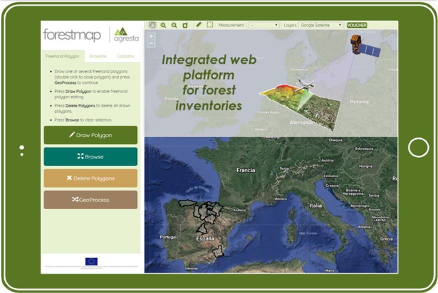
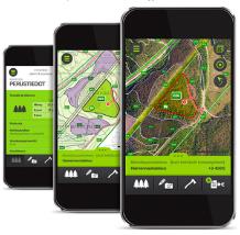
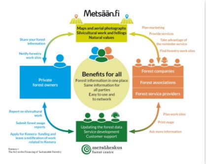
Metsään.fi provides eServices for forest owners and forestry service providers. The online application shows the maps, forest information and, silvicultural and cutting possibilities of each forest estate and their compartments:

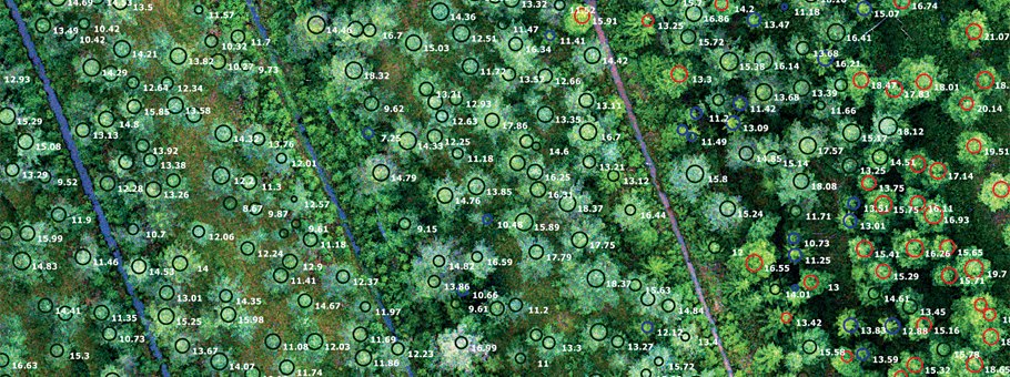
  1. Soil and forest site type
  2. Growing stock
  3. Treatment proposals for a five-year period
  4. Natural values (habitats of special importance)
  5. Latest maps and aerial photographs with compartment borders
  6. Annual growth. 

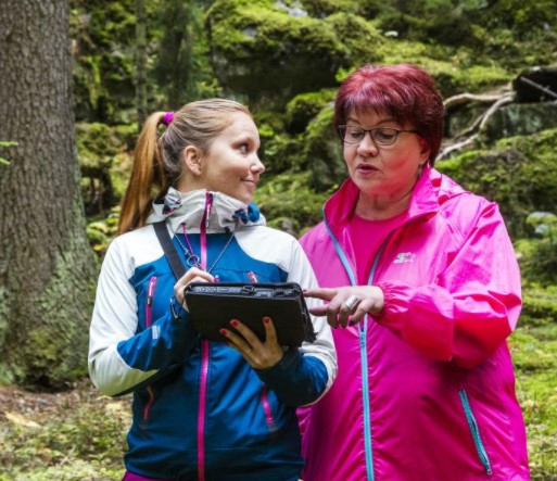
Metsään.fi also allows forest owners to apply for subsidies for improvement of young stands and declare notifications of forest use (e.eg. cuttings) by filling e-forms instead of paper ones. In addition, forest owners can contact forest service producers via the system. Metsään.fi is quite easy to use and it provides the forest owner many new flexible services, e.g. e-forms for applying subsidies. It’s a safe system, although being a public one.  A strong identification of the user is needed, use of Suomi.fi e-Identification is safe and provided by the state. Suomi.fi e-Identification contains a list of the identification tokens for example using online banking codes, mobile certificate or certificate cards

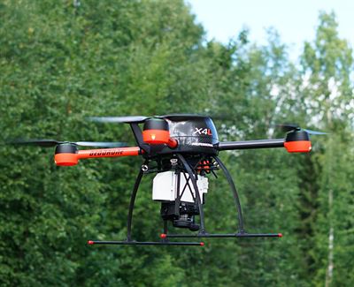
The Finnish Forest Centre collects and maintains remote sensing based data of forest resources covering the private forests. Metsään.fi is a free portal using that forest data for serving forest owners and forestry service providers. It has been found to encourage forest owners to carry out silvicultural works and generally for developing forest businesses. 

Metsään.fi in numbers in early 2020: 13,5 million hectares of forest data in the service, 108 765 forest owners have visited the service, 942 service providers have joined the service, 2461 operators use the service, 8,4 million hectares available to operators, 537 706 consents available to operators.

Eigentümer oder Autorenorganisation
Metsäkeskus
Name des Reporters
Anne Saloniemi
E-Mail des Reporters
Hauptbild
Logo der Best Practice
Logo des Projekts
Zusätzliches Bildmaterial 1
BP - Rosewood - V1
YES
Potenzial für Nachhaltigkeit - Wert
Very Positive
Herkunftsland
Finnland
Umfang der Anwendung
Projekt, in dessen Rahmen dieses Factsheet erstellt wurde
Hat Video
no
Englisch
Innovation
No
Source of wood

Stemwood

Code
BP_FI_11
Time scale
Running
Mobilisierungspotenzial
Not possible to assess
Art des betroffenen Holzes
Stemwood, Above and below ground woody biomass
Potenzial für Nachhaltigkeit
High
Auswirkungen auf Umwelt und Biodiversität

Positive

Leichte Implementierung
Easy
Wirtschaftliche Auswirkungen
Positive
Arbeitsplatzeffekt
Very positive
Einkommenseffekt
Positive
Spezifisches Wissen erforderlich
Knowing KEMERA system is needed
Kosten der Implementierung

Depends of type of subsidy

Technical readiness level
Applicable
Wichtige Voraussetzungen

State support for forestry

Location
Finland
Implementers
State and private forest owners
Actual status
Running
Anhänge
Country Region City
Finland
Scope
National
Voting
0%
Digitale Lösung
No
Herkunft des Holzes
Art des Holzes
Zusammenfassung

The purpose of the act on the financing of sustainable forestry (Kemera-law) is to advance economically, ecologically and socially sustainable silviculture and use of the forests. A private forest owner may receive financial support from the State for forest management, forest improvement work and for nature management. Public funding for forestry is based on the Act on the Financing of Sustainable Forestry. The general objectives of forestry financing are stated in the Act: increase the growth of forests, maintain road networks for forestry purposes, secure the biodiversity of forests and promote the adaptation of forests to climate change.

Government subsidies are essential for safeguarding sustainable wood production, maintenance of forest biodiversity and improvement of the health of forests. The most common reason not to participate in the cost sharing program is the challenge in applying the support. The receipt of Kemera subsidies requires a implementation plan or an application for support and declaration of completion. The amount of Kemera support varies by type of work and by financial zone. Support is a taxable income and the funding is provided by the Finnish Forest Center. Forest management and improvement work which may be eligible for support include the tending of seedling stands, tending of young stands, ditch cleaning and supplementary ditching and construction of forest roads. Support may also be granted for remedial fertilisation.

Eigentümer oder Autorenorganisation
Metsäkeskus Forest Centre
Hauptbild
Logo des Projekts
Nabe
Northern Hub
BP - Rosewood - V1
YES
Herkunftsland
Finnland
Titel (nationaler Name)
KEMERA
Umfang der Anwendung
Projekt, in dessen Rahmen dieses Factsheet erstellt wurde
Hat Video
no