Regional/sub-national

×

Fehlermeldung

Notice: Undefined index: #markup in bootstrap_preprocess_field() (Zeile 92 von /data/www/rosewood.admin.v4/sites/all/themes/bootstrap/template.php).
Englisch
Innovation
Yes
E-Mail des Eigentümers oder Autors
Voting
0%
Startjahr
2015
Endjahr
2018
Schlüsselwörter
Kurze Beschreibung
Calculation tool for the establishment and operation of biomass trading centers
Digitale Lösung
No
Zusammenfassung

Biomass Logistic and Trade Centres (BLTCs) are local or regional centres with optimised logistics and trading organization, where different woody bioenergy products (or heat) are marketed at standardised quality focusing on the domestic market uptake. It’s an innovative business model competitively operating as an intermediator to organise local woody bioenergy value chains between local biomass suppliers and customers of different scale from private households up to deliveries to heat and power plants. BioRES supported setting-up such BLTCs in Bulgaria, Croatia and Serbia.

Starting point are web-based marketing and sales platform with limited physical infrastructure. This can be successively extended into a BLTC with its own production, storage and logistics facilities when the local market reaches critical volumes allowing for the amortization of investments. In Slovenia, Austria, Germany and Finland BLTCs of different shape with own production, storage and logistic facilities are competitively operating. BioRES aims to setting up at least 6 – 8 new BLTCs in distributed over at least 2 of the 3 countries in Croatia, Serbia and Bulgaria during the project.

Eigentümer oder Autorenorganisation
GIZ Deutsche Gesellschaft für Internationale Zusammenarbeit GmbH
Name des Eigentümers oder Autors
Frank Mischler
Organisation der Reporter
Waldverband Steiermark
Name des Reporters
Maximilian Handlos
Projekt-Referenz
Horizon 2020 no. 645994, 2015-2018
Titel der Ressource 1
BioRES presentation (2015)
Hauptbild
Logo der Hauptorganisation
Logo des Projekts
Zusätzliches Bildmaterial 1
Nabe
Northern Hub
BP - Rosewood - V1
NO
Herkunftsland
Österreich
Finnland
Deutschland
Serbien
Slowenien
Umfang der Anwendung
Projekt, in dessen Rahmen dieses Factsheet erstellt wurde
Hat Video
no
Englisch
Innovation
Yes
E-Mail des Eigentümers oder Autors
Mobilisierungspotenzial
High, through public, user-friendly, easily accessible information about the site conditions of forest areas in NRW. For forest owners or forestry contractors, fact-based forest management or planning of harvesting operations are supported.
Art des betroffenen Holzes
All types of wood
Potenzial für Nachhaltigkeit
Data-based local, site-specific and individual support for sustainable forest management.
Auswirkungen auf Umwelt und Biodiversität

The included map-based information on soil conditions, meteorological data, climate scenarios have been interlinked with the Reforestation Concept and the Forest Management Concept of the state NRW. Increasing biodiversity and forest resilience by introducing mixed, multi-cohort forest stands is at the core of these concepts which are based on specific, locally site-adapted "forest development types". The platform is public, available also on mobile devices and user friendly. The usability is constantly tested and improved.

Id: 2861876
Continent Code: EU
Country Code: DE
Country Name: Germany
Name: North Rhine-Westphalia
Leichte Implementierung
The difficulty lies in the (public) availability of the different databases and the cooperation of the services behind them.
Spezifisches Wissen erforderlich
Integration of geoinformation, geological and meteorological services, forest management & development, ecology
Wichtige Voraussetzungen

The platform is based on the Open Data NRW strategy and draws significantly on the broad availability of geological data provided by the Geological Service North-Rhine Westphalia. The promotion of geoinformation data and their public availability in NRW has a longstanding tradition. In addition, the collboration of these public stakeholders (IT NRW, Geological Service NRW, State Enterprise Forest and Timber NRW) has been actively developed over many years.

Voting
0%
Kurze Beschreibung
Information platform on forests in NRW incl. interactive digital maps on forest cover, ecology, geology, types of use and calamities.
Digitale Lösung
Yes
Verwertungspotenzial

Cost-free public service

Zusammenfassung

The internet portal Waldinfo.NRW offers comprehensive public information on the forests in North Rhine-Westphalia, their diverse functions and sustainable management. This primarily includes digital maps on various aspects of forests, forest management and the use of forests by the public. The topics covered by the various maps range from forest cover and forest ecology, forest management and forest nature conservation to recreational use, danger prevention and forest administration. The information provided is intended in particular to support forest owners in the adaptation of forest management to climate change. This also includes forest regeneration on the current large damaged areas. The selection of maps and the design of the user interface provide user-friendly access to the specialist information. The portal also refers to selected important specialist publications of the State Forestry Administration and further websites of the State Administration. The internet portal Waldinfo.NRW is an important component of the NRW Forest Information System and the NRW Forest Climate Adaptation Strategy. The digital offer of public forest information also corresponds to the Open Data process in North Rhine-Westphalia (Open.NRW).

Eigentümer oder Autorenorganisation
Ministerium für Umwelt, Landwirtschaft, Natur- und Verbraucherschutz des Landes Nordrhein-Westfalen
Organisation der Reporter
Landesbetrieb Wald und Holz NRW
Name des Reporters
Marie-Charlotte Hoffmann, Elke Hübner-Tennhoff
Hauptbild
Logo der Best Practice
Logo der Hauptorganisation
Zusätzliches Bildmaterial 1
Zusätzliches Bildmaterial 2
Zusätzliches Bildmaterial 3
Leichte Implementierung - Bewertung
Medium
Nabe
Central-West Hub
Herkunftsregion
2861876
BP - Rosewood - V1
NO
Potenzial für Nachhaltigkeit - Wert
Very Positive
Herkunftsland
Deutschland
Titel (nationaler Name)
Waldinformationssystem NRW
Umfang der Anwendung
Projekt, in dessen Rahmen dieses Factsheet erstellt wurde
Rosewood Video
Video ansehen
Unser Wald im Klimawandel (2019)
Hat Video
yes
Französisch
Innovation
Yes
E-Mail des Eigentümers oder Autors
Mobilisierungspotenzial
Difficile à définir. En se basant sur l'abattage annuel et les possibilités dans La Rioja, cela pourrait être entre 100 000 et 250 000 m3 de bois, mais ce ne serait pas uniquement grâce à ce système.
Art des betroffenen Holzes
Bois sur pied
Potenzial für Nachhaltigkeit
Faciliter la gestion durable des forêts et la mobilisation du bois
Auswirkungen auf Umwelt und Biodiversität

Difficile à estimer

Id: 3336897
Continent Code: EU
Country Code: ES
Country Name: Espagne
Name: La Rioja
Leichte Implementierung
Une application très simple d'utilisation a été créée afin de la rendre accessible à tous , avec une variante de base pour tous les publics à l'utilisation intuitive et une variante plus avancée pour les techniciens (cette dernière a été accompagnée d'une
Wirtschaftliche Auswirkungen
Elevé à l'échelle des utilisateurs de la forêt, facilite de nombreux processus liés aux services forestiers publics et réduit les coûts d'inventaire pour les utilisateurs publics et privés.
Arbeitsplatzeffekt
Difficile à préciser
Spezifisches Wissen erforderlich
Pour la variante tout public, aucune, seulement la connaissance de l'emplacement de la parcelle et un accès à Internet. Pour la variante technique, la connaissance des forestiers et quelques rudiments d'utilisation de l'application sont nécessaires.
Kosten der Implementierung

Gratuit pour les utilisateurs.

Voting
0%
Startjahr
2018
Endjahr
2020
Titel (Abkürzung)
Forest-LidarRioja
Kurze Beschreibung
<p>Ce projet a permis de créer une cartographie actualisée des principales espèces forestières de La Rioja, en collectant des données telles que le volume de bois, la hauteur des arbres et la structure de la végétation pour chaque 25x25m de terrain, avec un très haut niveau de résolution.</p>
Digitale Lösung
Yes
Herkunft des Holzes
Zusammenfassung

Le groupe opérationnel Forest-LidaRioja a été formé dans le but de développer un inventaire forestier et une carte du modèle de combustible de La Rioja en utilisant les technologies de télédétection.

Cet outil contribue à la mise en place d'une gestion durable des forêts en utilisant des données précises et actualisée comme support de décision pour mettre en place des actions spécifiques dans les zones forestières.

Ce projet a permis de développer des méthodologies et des processus pour l'intégration de différentes sources d'information (principalement le LiDAR aéroporté des données PNOA 2016 et les informations satellitaires OPTICA). Ces méthodes sont soutenues par le développement d'algorithmes qui corrèlent par des méthodes statistiques des données précises de terrain avec les données LiDAR, nécessitant la réalisation de parcelles forestières très bien calibrées et de mesures situées avec une précision sub-métrique dans des points stratégiques pour chaque espèce forestière et zone de travail.

Les principaux résultats du projet Forest-LidaRioja sont les suivants :

- Inventaire forestier des forêts de La Rioja.

- Cartographie des modèles de combustible de la zone forestière de La Rioja pour planifier les travaux de prévention des incendies de forêt.

- Étude de l'évolution des peupleraies de la région et de leur potentiel d'approvisionnement.

- Formation technique sur les produits générés pour les professionnels intéressés par leur utilisation pratique. 

Les produits générés sont ouverts au public afin que chacun puisse les télécharger et les utiliser.

Eigentümer oder Autorenorganisation
Agresta S. Coop.
Name des Eigentümers oder Autors
David García
Organisation der Reporter
CESEFOR
Name des Reporters
Ángela García de Arana
E-Mail des Reporters
Projekt-Referenz
FEADER
Titel der Ressource 1
Spatial Data Infrastructures of the Government of La Rioja (IDErioja)
Ressource 2 Titel
Application for consulting and extracting data from specific plots of land
Hauptbild
Logo der Best Practice
Logo der Hauptorganisation
Kosten der Implementierung (Euro - €)
243000.00 €
Leichte Implementierung - Bewertung
Very easy
Nabe
South-Western Hub
Herkunftsregion
3336897
BP - Rosewood - V1
NO
Potenzial für Nachhaltigkeit - Wert
Very Positive
Herkunftsland
Spanien
Titel (nationaler Name)
Forest-LidarRioja
Umfang der Anwendung
Projekt, in dessen Rahmen dieses Factsheet erstellt wurde
Rosewood Video
Video ansehen
Forest-LidaRioja
Hat Video
yes
Italienisch
Innovation
Yes
E-Mail des Eigentümers oder Autors
Voting
0%
Startjahr
2019
Endjahr
2022
Titel (Abkürzung)
IT FOR II
Digitale Lösung
Yes
Art der Lösung
Zusammenfassung
ll progetto ITFORII ha come obiettivo primario il superamento della difficoltà di commercializzazione della materia legno (problema individuato) da parte delle imprese forestali venete che, per mancanze strutturali e gestionali, nonché per le difficoltà attuali di recessione economica, si trovano a svendere e a non valorizzare economicamente il legname lavorato.
Il progetto è finalizzato alla creazione di un sistema modulare e multi-misura di offerta e vendita di legname da parte delle imprese boschive, sistema che, allo stesso tempo, vuole diventare un collettore e gestore di dati forniti dalle imprese. La piattaforma punterà ad essere il più possibile flessibile, adattandosi sia alle imprese forestali strutturate, sia alle imprese individuali e alle aziende agricole operanti nel settore foresta-legno. La piattaforma verrà successivamente gestita dalla rete delle Camere di Commercio della Regione Veneto garantendo trasparenza ed efficace al sistema di pubblicità e compravendita della materia legnosa.
Eigentümer oder Autorenorganisation
portalelegnoveneto@tb.camcom.it
Name des Eigentümers oder Autors
Luca Canzan
Organisation der Reporter
AIEL
Name des Reporters
Andrea Argnani
E-Mail des Reporters
Hauptbild
BP - Rosewood - V1
NO
Herkunftsland
Italien
Titel (nationaler Name)
IT FOR II
Umfang der Anwendung
Projekt, in dessen Rahmen dieses Factsheet erstellt wurde
Hat Video
no
Englisch
Innovation
Yes
E-Mail des Eigentümers oder Autors
Voting
0%
Startjahr
2019
Endjahr
2022
Titel (Abkürzung)
IT FOR II
Kurze Beschreibung
<table border="0" cellpadding="0" cellspacing="0" style="width:357px;" width="357"> <tbody> <tr height="60"> <td height="60" style="height:60px;width:357px;">A digital platform for the timber market</td> </tr> </tbody> </table>
Digitale Lösung
Yes
Art der Lösung
Zusammenfassung
The project has as objective to overcome the difficulties in the trade of the timber resource. This problem was identified, by the forest enterprises of the region, in the lack of managment and in the economical crisis making forest enterprises unable to sell the timber at a proper price. The system aims to create a modular system and with different measure units of offers and sales from the forest enterprises directly. The platform that, simoultaneously, is able to collect all the data timber related thanks to on-site apps can provide useful services and to ensure the traceability of the timber. The platform will be malleable to forest enterprises requests. 
Eigentümer oder Autorenorganisation
portalelegnoveneto@tb.camcom.it
Name des Eigentümers oder Autors
Luca Canzan
Organisation der Reporter
AIEL
Name des Reporters
Andrea Argnani
E-Mail des Reporters
Hauptbild
BP - Rosewood - V1
NO
Herkunftsland
Italien
Titel (nationaler Name)
IT FOR II
Umfang der Anwendung
Projekt, in dessen Rahmen dieses Factsheet erstellt wurde
Hat Video
no
Italienisch
Innovation
Yes
E-Mail des Eigentümers oder Autors
Voting
0%
Startjahr
2018
Endjahr
2021
Schlüsselwörter
Titel (Abkürzung)
LogistiCIPlus
Digitale Lösung
No
Zusammenfassung
Il progetto riguarda il miglioramento dell’efficienza del produzione di energia da biocombustibili forestali, tramite il miglioramento logistico del processo di ottenimento del materiale. Il progetto prevede l’adozione di uno strumento per il supporto alla tracciabilità e alla valutazione della sostenibilità ambientale. L’obiettivo è quello di porre le basi concrete per il miglioramento dell'efficienza nell’organizzazione dei cantieri di raccolta e trasformazione delle biomasse e di conseguenza ridurre in modo significativo le emissioni di CO2 e di altri gas clima-alteranti prodotti durante le fasi di ottenimento della materia prima, movimentazione, lavorazione e di commercializzazione dei biocombustibili legnosi. Le attività daranno quindi poi come output l’assunzione ed il miglioramento delle pratiche utili alle imprese per garantire il monitoraggio dei flussi di materiale all’interno dei cantieri e dei centri logistici dell’azienda, nonché informazioni certificate rispetto all’impatto ambientale dell’azienda nel produrre il biocombustibile.
Eigentümer oder Autorenorganisation
Tecnerga
Name des Eigentümers oder Autors
Massimo Ramina
Organisation der Reporter
AIEL
Name des Reporters
Andrea Argnani
E-Mail des Reporters
Hauptbild
BP - Rosewood - V1
NO
Titel (nationaler Name)
LogistiCIPlus
Umfang der Anwendung
Projekt, in dessen Rahmen dieses Factsheet erstellt wurde
Hat Video
no
Französisch
Innovation
Yes
E-Mail des Eigentümers oder Autors
Voting
0%
Startjahr
2021
Kurze Beschreibung
<table border="0" cellpadding="0" cellspacing="0" style="width:491px;" width="490"> <tbody> <tr height="60"> <td height="60" style="height:60px;width:491px;">Le projet vise l'utilisation des nouvelles technologies pour rendre le système de vente de bois plus dynamique et économique, et fluidifer le transfert d'information. Deux outils ont été mis en place: Sylvatrade, un système digitalisé de vente aux enchères de bois et Neosylvaq, une plateforme digitale de partage de données SIG.</td> </tr> </tbody> </table>
Zusammenfassung
L'outil de vente assistée par ordinateur (SYLVATRADE) est une plateforme créée à partir d'une base de données afin de générer des enregistrements standardisés de lots, et éditer des contrats. Elle est associée à la plateforme cartographique NEOSYLVAQ pour donner à l'acheteur un vue d'ensemble des lots, localiser et délimiter chaque parcelle sur une carte, accéder aux itinéraires et enfin faciliter l'organisation des visites de terrain. Au moment de la transaction, l'acheteur détient plusieurs informations sur la parcelle sur sa tablette numérique: situation géographique, cadastre, superficie, essences, densité de peuplement, certification ou non,..etc. L'acheteur a 30 secondes pour faire une offre. Un procédé informatique quasi-instantané donne la possibilité pour la salle entière de visualiser la meilleure offre et la somme. La gestion informatisée permet de traiter la vente d'environ 90 000m3 de bois en 2 heures. Le solde des ventes peut être réalisé par ordinateur et par essences, classe de volumes, et unités géographiques. Les ventes de groupes peuvent être suivies à distance sur internet, où sur place au moyen de tablette numériques. Les documents administratifs (contrats, billets à ordre,...) sont publiés à l'issue de la vente et signés par voie électronique à la sortie.
Eigentümer oder Autorenorganisation
Cabinet Coudert
Name des Eigentümers oder Autors
Cabinet Coudert
Organisation der Reporter
CRPF
Name des Reporters
Henri Husson
E-Mail des Reporters
Hauptbild
BP - Rosewood - V1
NO
Herkunftsland
Frankreich
Titel (nationaler Name)
Neosylvaq
Umfang der Anwendung
Projekt, in dessen Rahmen dieses Factsheet erstellt wurde
Hat Video
no
Spanisch
Innovation
Yes
E-Mail des Eigentümers oder Autors
Mobilisierungspotenzial
Difícil de definir, pero basando se en las cortas anuales y en las posibilidades en la Rioja podría ponerse entre 100.000 y 250.000 m3 de madera, pero no sería sólo por este sistema.
Art des betroffenen Holzes
Madera en pie
Potenzial für Nachhaltigkeit
Facilitar la gestión forestal sostenible y la movilización de madera
Auswirkungen auf Umwelt und Biodiversität

Difícil de estimar.

Leichte Implementierung
Se ha creado una aplicación de uso muy sencillo para que sea fácil de utilizar por todos, con una variante básica para todos los públicos de uso intuitivo y una variante más avanzada para técnicos (esta última se acompañó de una formación)
Wirtschaftliche Auswirkungen
Alto a la escala de usuarios forestales, facilita muchos procesos ligados a los servicios públicos forestales y disminuye costes de inventario tanto para usuarios públicos como privados.
Spezifisches Wissen erforderlich
Para la variante todos los públicos ninguno, sólo conocer la localización de la parcela y disponer de acceso a internet, para la variante técnica conocimientos propio de ingenieros forestales y algunos rudimentos de uso de la aplicación.
Kosten der Implementierung

Gratuito para usuarios

Voting
0%
Startjahr
2018
Endjahr
2020
Titel (Abkürzung)
Forest-LidaRioja
Kurze Beschreibung
<p>Este proyecto ha creado una cartografía actualizada de las principales especies forestales de La Rioja, recogiendo datos como el volumen de madera, las alturas de los árboles y la estructura de la vegetación para cada 25x25m de terreno, con un nivel de resolución muy alto.</p>
Digitale Lösung
Yes
Herkunft des Holzes
Zusammenfassung

El grupo operativo Forest-LidaRioja se ha constituido con el objetivo de desarrollar un inventario forestal y un mapa de modelos de combustible de La Rioja utilizando tecnologías de teledetección.

Entre las principales utilidades prácticas, destaca la importancia para la mejora de la gestión forestal sostenible, ya que con datos precisos y actualizados se pueden tomar mejores decisiones y planificar mejor las actuaciones en las zonas forestales.

Este proyecto ha permitido el desarrollo de metodologías y procesos para la integración de diferentes fuentes de información (principalmente LiDAR aerotransportado de datos PNOA 2016 e información satelital OPTICA). Estos métodos se apoyan en el desarrollo de algoritmos que correlacionan por métodos estadísticos los datos precisos del terreno con los datos LiDAR, requiriendo la realización de parcelas forestales muy bien calibradas y mediciones localizadas con precisión submétrica en puntos estratégicos para cada especie forestal y zona de trabajo.

Los principales resultados del Proyecto Forestal-LidaRioja son:

- Inventario forestal de los bosques de La Rioja.

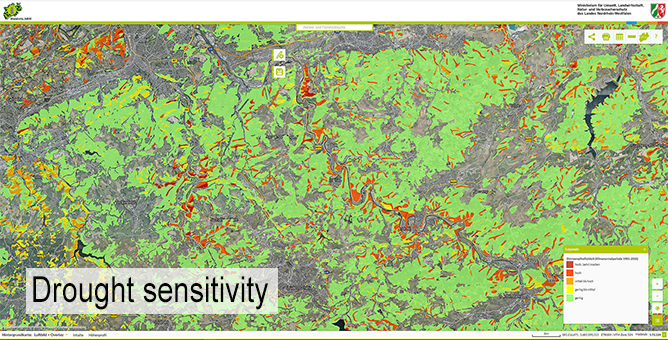
- Cartografía de modelos de combustible de la zona forestal de La Rioja para planificar los trabajos de prevención de incendios forestales.

- Estudio de la evolución de las choperas de la región y su potencial de abastecimiento.

- Formación técnica sobre los productos generados para los profesionales interesados en su uso práctico. 

Los productos generados están abiertos al público para que cualquier persona pueda descargarlos y utilizarlos.

Eigentümer oder Autorenorganisation
Agresta S. Coop.
Name des Eigentümers oder Autors
David García
Organisation der Reporter
CESEFOR
Name des Reporters
Ángela García de Arana
E-Mail des Reporters
Projekt-Referenz
FEADER
Titel der Ressource 1
Spatial Data Infrastructures of the Government of La Rioja (IDErioja)
Ressource 2 Titel
Application for consulting and extracting data from specific plots of land
Hauptbild
Logo der Best Practice
Logo der Hauptorganisation
Kosten der Implementierung (Euro - €)
243000.00 €
Leichte Implementierung - Bewertung
Very easy
Nabe
South-Western Hub
BP - Rosewood - V1
NO
Potenzial für Nachhaltigkeit - Wert
Very Positive
Herkunftsland
Spanien
Umfang der Anwendung
Projekt, in dessen Rahmen dieses Factsheet erstellt wurde
Rosewood Video
Video ansehen
Forest-LidaRioja
Hat Video
yes
Spanisch
Innovation
Yes
E-Mail des Eigentümers oder Autors
Voting
0%
Startjahr
2018
Endjahr
2020
Kurze Beschreibung
<table border="0" cellpadding="0" cellspacing="0" style="width:496px;" width="496"> <tbody> <tr height="60"> <td height="60" style="height:60px;width:496px;"> <table border="0" cellpadding="0" cellspacing="0" style="width:464px;" width="464"> <tbody> <tr height="60"> <td height="60" style="height:60px;width:464px;">En este proyecto se ha creado una cartografía actualizada de las principales especies forestales riojanas, recogiendo datos como el volumen de madera, las alturas de los árboles y la estructura de la vegetación de 25x25m de terreno, un nivel de resolución muy alto</td> </tr> </tbody> </table> </td> </tr> </tbody> </table>
Digitale Lösung
Yes
Zusammenfassung
El grupo operativo Forest-LidaRioja se ha conformado con el objetivo de elaborar un inventario forestal y un mapa de modelos de combustibles de La Rioja utilizando tecnologías de teledetección.
Entre las principales utilidades prácticas podemos destacar la importancia que tiene para mejorar la gestión forestal sostenible, ya que con datos precisos y actualizados pueden tomarse decisiones más acertadas y planificar mejor las acciones en zonas forestales.
Este proyecto ha permitido desarrollar metodologías y procesos para la integración de diferentes fuentes de información (principalmente LiDAR aerotransportado procedentes de datos PNOA 2016 e información satelital ÓPTICA). Estos métodos se apoyan en el desarrollo de algoritmos que correlacionan por métodos estadísticos datos precisos de terreno con datos LiDAR, exigiendo la realización de parcelas y mediciones forestales muy bien calibradas y localizadas con precisión submétrica en puntos estratégicos para cada especie forestal y zona de trabajo
Los principales resultados del Proyecto Forest-LidaRioja son:
• Inventario forestal de los bosques de La Rioja.
• Cartografía de modelos de combustibles de la superficie forestal riojana para planificar trabajos preventivos de incendios forestales.
• Estudio de la evolución de las choperas de la región y potencial de abastecimiento
• Formación técnica sobre los productos generados a profesionales interesados para su utilización práctica. 
Los productos generados están abiertos al público para que cualquier persona pueda descargarlos y utilizarlos. 
Eigentümer oder Autorenorganisation
Agresta S. Coop.
Name des Eigentümers oder Autors
David García
Organisation der Reporter
CESEFOR
Name des Reporters
Ángela García de Arana
E-Mail des Reporters
Projekt-Referenz
FEADER
Titel der Ressource 1
Spatial Data Infrastructures of the Government of La Rioja (IDErioja)
Ressource 2 Titel
Application for consulting and extracting data from specific plots of land
Hauptbild
BP - Rosewood - V1
NO
Herkunftsland
Spanien
Titel (nationaler Name)
Forest-LidaRioja: inventario forestal y mapa de modelos de combustibles basado en teledetección
Umfang der Anwendung
Projekt, in dessen Rahmen dieses Factsheet erstellt wurde
Hat Video
no
Slowenisch
Innovation
Yes
E-Mail des Eigentümers oder Autors
Voting
0%
Kurze Beschreibung
<table border="0" cellpadding="0" cellspacing="0" style="width:256px;" width="256"> <tbody> <tr height="60"> <td height="60" style="height:60px;width:256px;">Marteloscope demonstracijska ploskev Pahernik</td> </tr> </tbody> </table>
Digitale Lösung
Yes
Zusammenfassung
Pahernikovi gozdovi so postali del demonstracijske ploskve evropske mreže (Marteloscope) leta 2015. Temeljijo na načelu: "Če vidiš, bolje razumeš." Namen je pokazati, da je to mogoče ob upoštevanju socialnih funkcij gozdov in funkcije pridobivanja lesa pri gospodarjenju z gozdovi, vključno z ohranjanjem biotske raznovrstnosti.
Eigentümer oder Autorenorganisation
Gozdarski inštitut Slovenije
Name des Eigentümers oder Autors
Nikica Ogris
Organisation der Reporter
Zavod za gozdove Slovenije
Name des Reporters
Boris Rantaša
E-Mail des Reporters
Hauptbild
BP - Rosewood - V1
NO
Herkunftsland
Slowenien
Umfang der Anwendung
Projekt, in dessen Rahmen dieses Factsheet erstellt wurde
Hat Video
no