Waldstörungen, Risiken, Katastrophenschutz

×

Fehlermeldung

  • Notice: Undefined index: #markup in bootstrap_preprocess_field() (Zeile 92 von /data/www/rosewood.admin.v4/sites/all/themes/bootstrap/template.php).
  • Notice: Undefined index: #markup in bootstrap_preprocess_field() (Zeile 92 von /data/www/rosewood.admin.v4/sites/all/themes/bootstrap/template.php).
  • Notice: Undefined index: #markup in bootstrap_preprocess_field() (Zeile 92 von /data/www/rosewood.admin.v4/sites/all/themes/bootstrap/template.php).
  • Notice: Undefined index: #markup in bootstrap_preprocess_field() (Zeile 92 von /data/www/rosewood.admin.v4/sites/all/themes/bootstrap/template.php).
Slowenisch
Innovation
No
E-Mail des Eigentümers oder Autors
Voting
0%
Kurze Beschreibung
Spletno mesto vsebuje informacije o napadih podlubnikov: zgradba sanitarnih posekov zaradi žuželk po območjih, znaki napada, nastavljanje pasti, gradacije hroščev in interaktivni zemljevid kontrolnih pasti.
Digitale Lösung
Yes
Zusammenfassung

Glavni namen Varstva gozdov pred podlubniki je informiranje in izobraževanje. Pokriva različne vidike napadov podlubnikov: izvedena sanitarna sečnja, izobraževanja o znakih napada, zakonskih določil o napadih,… Posreduje informacije o preteklem poteku gradacij, sanitarnega poseka in prediktivne modele za prihodnje. Stran opozarja lastnike gozdov o času sanitarnega poseka zaradi podlubnikov gglede na razvojni cikel podlubnikov. Izobražuje o znakih napada in prepoznavnju le-teh. Informira o zakonskih določilih, ki se tičejo napadov podlubnikov. vsebuje interaktivne karte napadov podlubnikov na državnem nivoju. Vsebuje izobraževalna gradiva o znakih napada podlubnikov, strokovna priporočila o postavljanju in čiščenju kontrolnih pasti na skladiščih gozdnih lesnih sortimentov, ukrepe za zatiranje podlubnikov, navodila za uporabo fitofarmacebtskih sredstev za zatiranje podlubnikov, namnožitev podlubnikov za preteklo obdobje in analizo razvoja osmerozobega smrekovega lubadarja na interaktivni kartu.

Eigentümer oder Autorenorganisation
Slovenia Forest Service
Organisation der Reporter
Slovenian Forestry Institute
Name des Reporters
Andreja Vedenik
E-Mail des Reporters
Hauptbild
BP - Rosewood - V1
NO
Herkunftsland
Slowenien
Titel (nationaler Name)
Varstvo gozdov pred podlubniki
Umfang der Anwendung
Projekt, in dessen Rahmen dieses Factsheet erstellt wurde
Hat Video
no
Englisch
Innovation
No
E-Mail des Eigentümers oder Autors
Voting
0%
Kurze Beschreibung
The website provides information on outbreaks of bark beetles: structure of sanitary felling due to insects by areas, signs of an attack, setting traps, gradations of beetles, and an interactive map of control sample traps.
Digitale Lösung
Yes
Zusammenfassung

The main purpose of the Forest Protection against beetles is informing and educating. It covers various aspects of beetle attacks. Provides information on the past course of gradations, sanitary felling in predictive models for the future. The site reminds forest owners about timing of sanitary felling due to bark beetle in view of the development cycle. Informs about legal framework relating to bark beetle attacks. It contains interactive maps of beetle attacks at the state level, educational materials on important attacks of beetles, expert recommendations for setting and cleaning control traps in forest wood assortment warehouses, organization for beetle control, instructions for using phytopharmaceuticals for beetle control, naming of beetles for the past period in the analyzed development of European spruce bark beetle.

Eigentümer oder Autorenorganisation
Slovenia Forest Service
Organisation der Reporter
Slovenian Forestry Institute
Name des Reporters
Andreja Vedenik
E-Mail des Reporters
Hauptbild
BP - Rosewood - V1
NO
Herkunftsland
Slowenien
Titel (nationaler Name)
Varstvo gozdov pred podlubniki
Umfang der Anwendung
Projekt, in dessen Rahmen dieses Factsheet erstellt wurde
Hat Video
no
Slowenisch
Innovation
Yes
E-Mail des Eigentümers oder Autors
Voting
0%
Kurze Beschreibung
Javen informacijski sistem za beleženje in kartiranje vrst gliv v Sloveniji.
Digitale Lösung
Yes
Zusammenfassung

Boletus informaticus je javen informacijski sistem za beleženje in kartiranje vrst gliv v Sloveniji. Sestavljajo ga osrednja podatkovna zbirka gliv v Sloveniji, spletna, mobilna in namizna aplikacija ter Mikoteka in herbarij Gozdarskega inštituta Slovenije. Informacijski sistem Boletus informaticus je rezultat sodelovanja med Gozdarskim inštitutom Slovenije, Mikološko zvezo Slovenije in Inštitutom za sistematiko višjih gliv.

Eigentümer oder Autorenorganisation
Gozdarski inštitut Slovenije
Name des Eigentümers oder Autors
Nikica Ogris
Organisation der Reporter
Gozdarski inštitut Slovenije
Name des Reporters
Polona Hafner
E-Mail des Reporters
Hauptbild
Zusätzliches Bildmaterial 1
BP - Rosewood - V1
NO
Herkunftsland
Slowenien
Titel (nationaler Name)
Boletus informaticus
Umfang der Anwendung
Projekt, in dessen Rahmen dieses Factsheet erstellt wurde
Hat Video
no
Englisch
Innovation
Yes
E-Mail des Eigentümers oder Autors
Voting
0%
Kurze Beschreibung
A public information system for the recording and mapping of fungi in Slovenia.
Digitale Lösung
Yes
Zusammenfassung

Boletus informaticus is a public information system for the recording and mapping of fungi in Slovenia. It consists of a central database of fungi in Slovenia, a web, mobile and desktop application, and a Mycotheca and Herbarium of Slovenian Forestry Institute. The information system Boletus informaticus is the result of cooperation between Slovenian Forestry Institute, Mycological Association of Slovenia, and Institute for systematics of higher fungi.

Eigentümer oder Autorenorganisation
Slovenian Forestry Institute
Name des Eigentümers oder Autors
Nikica Ogris
Organisation der Reporter
Slovenian Forestry Institute
Name des Reporters
Polona Hafner
E-Mail des Reporters
Hauptbild
Zusätzliches Bildmaterial 1
BP - Rosewood - V1
NO
Herkunftsland
Slowenien
Titel (nationaler Name)
Boletus informaticus
Umfang der Anwendung
Projekt, in dessen Rahmen dieses Factsheet erstellt wurde
Hat Video
no
Slowenisch
Innovation
Yes
E-Mail des Eigentümers oder Autors
Voting
0%
Startjahr
2016
Kurze Beschreibung
Spletna aplikacija Invazivke je del javnega elektronskega informacijskega sistema za zbiranje podatkov o invazivnih tujerodnih vrstah v Sloveniji.
Digitale Lösung
Yes
Zusammenfassung

Mobilna aplikacija Invazivke je brezplačna in je namenjena splošni javnosti. Za uporabo aplikacije se je potrebno registrirati s pomočjo veljavnega e-poštnega naslova. Namenjena je terenskemu zbiranju podatkov s pametno napravo, ki vključuje senzor GPS in digitalni fotoaparat. To nam omogoča, da z napravo avtomatsko zajamemo lokacijo (točni koordinati X in Y) in fotografijo, kar močno olajša in pospeši vnos podatkov. Uporabniku tako ostane le ročna izbira vrste iz spustnega seznama. V aplikaciji je na voljo tudi priročnik z opisom ITV, vključno s slikovnim gradivom za lažjo identifikacijo najdenega organizma. Mobilna aplikacija Invazivke omogoča beleženje najdb ITV brez internetne povezave. Izmenjava podatkov z osrednjim strežnikom poteka na zahtevo uporabnika, ko je priključen v medmrežje in se izvede po postopku sinhronizacije.


Eigentümer oder Autorenorganisation
Gozdarski inštitut Slovenije
Name des Eigentümers oder Autors
Nikica Ogris
Organisation der Reporter
Gozdarski inštitut Slovenije
Name des Reporters
Polona Hafner
E-Mail des Reporters
Projekt-Referenz
LIFE ARTEMIS
Hauptbild
Nabe
South-Eastern Hub
BP - Rosewood - V1
NO
Herkunftsland
Slowenien
Titel (nationaler Name)
Osveščanje, usposabljanje in ukrepanje za invazivne tujerodne vrste v gozdu
Umfang der Anwendung
Projekt, in dessen Rahmen dieses Factsheet erstellt wurde
Hat Video
no
Englisch
Innovation
Yes
E-Mail des Eigentümers oder Autors
Voting
0%
Startjahr
2016
Titel (Abkürzung)
Kurze Beschreibung
The Invazivke web application is part of the public electronic information system for collecting data on invasive alien species in Slovenia.
Digitale Lösung
Yes
Zusammenfassung

The mobile application Invazivke is free to use and is intended for the general public. To use the application, one must register using a valid email address. It is designed for field data collection with a smart device that includes a GPS sensor and a digital camera. This allows user to automatically capture the location (exact X and Y coordinates) and photo with the device, which greatly facilitates and speeds up data entry. The user manually selects of the species from the drop-down menu. The application also includes a manual with a description of invasive alien species (IAS), including pictorial material to facilitate the identification of the found organism. The mobile application Invazivke enables the recording of IAS finds without an internet connection. The exchange of data with the central server takes place at the request of the user when connected to the Internet and is carried out according to the synchronization process.

Eigentümer oder Autorenorganisation
Slovenian Forestry Institute
Name des Eigentümers oder Autors
Nikica Ogris
Organisation der Reporter
Slovenian Forestry Institute
Name des Reporters
Polona Hafner
E-Mail des Reporters
Projekt-Referenz
LIFE ARTEMIS
Hauptbild
Logo der Hauptorganisation
Logo des Projekts
Nabe
South-Eastern Hub
BP - Rosewood - V1
NO
Herkunftsland
Slowenien
Umfang der Anwendung
Projekt, in dessen Rahmen dieses Factsheet erstellt wurde
Hat Video
no
Schwedisch
Innovation
Yes
E-Mail des Eigentümers oder Autors
Voting
0%
Startjahr
2018
Kurze Beschreibung
<table border="0" cellpadding="0" cellspacing="0" style="width:539px;" width="539"> <tbody> <tr height="60"> <td dir="LTR" height="60" style="height:60px;width:539px;">Arboair precisionsskogsbruk är en hållbar tjänst som med hjälp av RGB- och multispektrala bilder från drönare, flygplan, helikoptrar eller satelliter kan upptäcka barkbaggarinfekterade eller stressade träd.</td> </tr> </tbody> </table>
Digitale Lösung
Yes
Zusammenfassung
Idag bygger tekniken för att identifiera granbarkborreangrepp i skogen till stor del på manuellt arbete genom visuella kontroller av skogsområden, där tidiga angrepp nästan är omöjliga att se, medan gamla attacker är lättare att upptäcka. Försök har gjorts för att identifiera tidiga angrepp med hjälp av satellitkartor som ger en bra indikation och kan ses som ett komplement till vår precisionsanalys. Arboair Forest Mapper är en tjänst där du analyserar dina bilder via vår AI. Vår modell är tränad på över 200 000 träd och den har verifierats av skogsförvaltare.

1. Samla in data 

Flyg drönaren själv
Använd en av våra drönarpartners
Använd en av våra satellitdatapartners för högupplösta satellitbilder
2. Analys

Granbarkborreangrepp
Trädslagsfördelning
Trädräkning
Vindfällen 
3. Ta del av ditt resultat

Titta på i Arboairs portal
Skicka resultatet till er egna plattform
Ladda ner och använd i QGIS, ArcGIS, Google Earth eller något annat GIS.

Eigentümer oder Autorenorganisation
Paper Province
Name des Eigentümers oder Autors
Marcus Drugge
Organisation der Reporter
Paper Province
Name des Reporters
Gunnar Hellerström
Hauptbild
BP - Rosewood - V1
NO
Herkunftsland
Schweden
Titel (nationaler Name)
Arboair AB
Umfang der Anwendung
Projekt, in dessen Rahmen dieses Factsheet erstellt wurde
Rosewood Video
Hat Video
yes
Deutsch
Innovation
Yes
Voting
0%
Startjahr
2018
Endjahr
2021
Kurze Beschreibung
<table border="0" cellpadding="0" cellspacing="0" style="width:573px;" width="573"> <tbody> <tr height="60"> <td height="60" style="height:60px;width:573px;">Das Fehlen von Standortskarten in der Steiermark bedingt einen neuen Ansatz bei der Standortserkundung und Kartierung der Waldstandorte. Daher soll eine Waldtypisierung auf Basis eines GIS-gestützten geoökologischen Stratifizierungsmodells erfolgen.</td> </tr> </tbody> </table>
Digitale Lösung
Yes
Zusammenfassung

Das weitgehende Fehlen von Standortskarten in der Steiermark macht einen neuen Ansatz bei der Standortserkundung und Kartierung der vorkommenden Waldstandorte notwendig. Eine weitere wissenschaftliche Herausforderung stellt die Berücksichtigung von zukünftig veränderten Klimabedingungen dar, die sich auch auf die Klassifizierung von Standorten und Waldtypen auswirken wird. Für eine solcherart erforderliche „dynamische Standortsklassifizierung“ bestehen theoretische Konzepte, die konkrete Umsetzung einer integrierten Standorts- und Waldtypenklassifikation in einer realen Region wie der Steiermark stellt jedoch Neuland dar.
Im Rahmen des Projektes soll daher eine Waldtypisierung auf Basis eines GIS-gestützten geoökologischen Stratifizierungsmodells erfolgen. Als Datenbasis sollen das digitale Höhenmodell, eine geologische Basiskarte, digital vorliegende Standorts- und Klimadaten sowie neu zu erhebende Standortsparameter verwendet werden. Für die Waldtypenkarte sollen auf Grundlage der Punkt- und Flächendaten zunächst Themenkarten für die Faktoren Wärme, Wasser und Nährstoffhaushalt modelliert werden, die dann zu Waldtypen mit einheitlicher Faktorenkombination zusammengefasst werden. Das Modell erlaubt dann auf Basis der Datengrundlagen abgeleiteten digitalen geoökologischen Parametern (u.a. Höhenstufe, Hanglage, Substrat, Geländeform, Neigung) eine Stratifizierung der Waldtypen auf allen Hauptwaldstandorten. Jeder Waldtyp wird auf der Waldtypenkarte im Maßstab 1:25.000 dargestellt. Neben den ökologischen Fakten ist jeder Waldtyp mit einer waldbaulichen Beschreibung versehen, die Angaben zu den geeigneten Baumarten, Gefährdungen und möglichen Behandlungsvarianten in Hinblick auf den Klimawandel enthält. In dieser waldbaulichen Charakterisierung werden auch die bisherigen Erfahrungen mit den vorhanden Baumarten und ihren Mischungen getrennt nach Waldtypen beschrieben und Empfehlungen für die zukünftige Bestockung und deren Bewirtschaftung in Hinblick auf den Klimawandel gegeben.

Eigentümer oder Autorenorganisation
BOKU - Universität für Bodenkultur Wien
Organisation der Reporter
Holzcluster Steiermark GmbH
Name des Reporters
DI Masa Jasarevic
Hauptbild
Logo der Hauptorganisation
Zusätzliches Bildmaterial 1
BP - Rosewood - V1
NO
Herkunftsland
Österreich
Umfang der Anwendung
Projekt, in dessen Rahmen dieses Factsheet erstellt wurde
Rosewood Video
Video ansehen
FORSITE (Austria) - ROSEWOOD4.0 Best Practice & Innovation
Hat Video
yes
Englisch
Innovation
Yes
E-Mail des Eigentümers oder Autors
Mobilisierungspotenzial
Very positive
Art des betroffenen Holzes
All wood produced in the forest system (trunk, branches, roots).
Potenzial für Nachhaltigkeit
Improves forests resilience to wildfires, water scarcity, environmental degradation and other effects induced by climate change
Auswirkungen auf Umwelt und Biodiversität
  • Demonstration and replication of a successful, innovative forest management scheme at a watershed scale. At the beginning it will be applied at sub catchment level in Spain (415 hectares), then at catchment level in Germany, Portugal and Spain (7,824 hectares) and finally it will be further expanded up to 350,000 hectares within five years from the project completion.
  • Reinforcement of mechanisms to develop climate change adaptation measures in rural areas and to ensure its socioeconomic sustainability;
  • Increased water reserves of 45-200 l/m²/year and increased water availability downstream, leading to a reduction in energy extraction costs to 5 W/hm;
  • Increased sustainable biomass production for bioenergy uses, between 10 and 15 t/ha year, including both forest and agricultural residues traditionally burned and usually the cause of wildfires.
  • Reduced fire hazards by 30%, protecting rural populations currently residing in risk areas
  • Increased resilience of 25% of forest areas to withstand droughts, pests and disease outbreak.
Id: 2593113
Continent Code: EU
Country Code: ES
Country Name: Spain
Name: Valencia
Leichte Implementierung
It is not easy to use, but we are developing user guides to make it easier.
Wirtschaftliche Auswirkungen
The tool is free, so the economic impact is positive as you provide a very powerful management tool at 0 cost.
Arbeitsplatzeffekt
The management that is proposed always generates jobs to carry it out.
Einkommenseffekt
If the management objective is to maximise productivity, revenues will also be maximised.
Spezifisches Wissen erforderlich
Knowledge of Geographic Information Systems is necessary to be able to prepare the input data for the tool.
Wichtige Voraussetzungen

Input data for the chosen mechanistic model.

Decision variables.

Constraints to be applied.

Voting
0%
Startjahr
2019
Endjahr
2023
Kurze Beschreibung
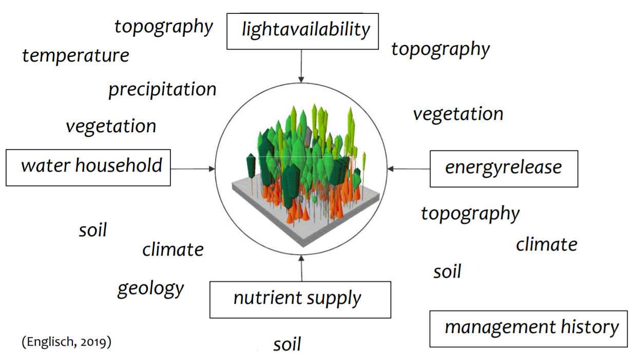
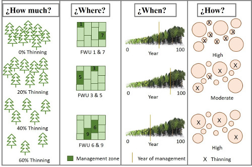
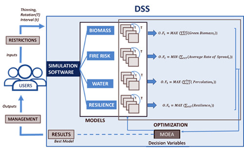
<p>C.A.F.E. determines the optimum silvicultural activities to manage multiple products, goods and services such as biomass production, C2 sequestration, fire risk, water provisioning , climatic resilience or biodiversity, for a selected solution.</p>
Digitale Lösung
Yes
Herkunft des Holzes
Verwertungspotenzial

High, as it is based on mechanistic modelling it can be applied in any climatic region. Furthermore, by including a wide range of ecosystem services, it can meet the needs of different types of forest management.

Zusammenfassung

This tool determines the optimum silvicultural activities to manage multiple products, goods and services such as biomass production, CO2 sequestration, fire risk, water provisioning, climatic resilience or biodiversity, which are simultaneously quantified in time and space for a selected solution. Main advantages include:

  • Changing the mono-objective approach in order to include a group of ecosystem goods and services.
  • Improving the economic performance of low productive areas by quantifying and valorising other resources that could be remunerated attending to the environmental value.
  • Holistic optimization of multiple goods and services out of forest management.
  • Adequacy to the specific characteristics of each site.
  • Multi-scalar results (plot, forest working unit, catchment, etc.).

C.A.F.E. is a tool that combines eco-hydrologic dynamic simulation with many-criteria optimization, where the user can carry out forest management according to more than one product at the same time, and choose the relevance of each objective/product. This software is capable of working under different climatic regions thanks to the previous calibration of the eco-hydrological simulation. Furthermore, it is possible to modify the spatial scale moving from plot to catchment, integrating a strong biophysical unit. In the same way, simulating different climatic scenarios is also possible. The result is a group of possible solutions among which forest manager can decide and apply.

Eigentümer oder Autorenorganisation
Technical University of Valencia
Name des Eigentümers oder Autors
María González Sanchis
Organisation der Reporter
CESEFOR
Name des Reporters
Ángela García de Arana
E-Mail des Reporters
Projekt-Referenz
The project LIFE RESILIENT FORESTS – Coupling water, fire and climate resilience with biomass production from forestry to adapt watersheds to climate change is co-funded by the LIFE Programme of the European Union under contract number LIFE 17 CCA/ES/000063
Hauptbild
Logo der Best Practice
Logo der Hauptorganisation
Logo des Projekts
Zusätzliches Bildmaterial 1
Zusätzliches Bildmaterial 2
Zusätzliches Bildmaterial 3
Leichte Implementierung - Bewertung
Medium
Nabe
South-Western Hub
Herkunftsregion
2593113
BP - Rosewood - V1
NO
Potenzial für Nachhaltigkeit - Wert
Very Positive
Herkunftsland
Belgien
Deutschland
Portugal
Spanien
Titel (nationaler Name)
LIFE RESILIENT FORESTS
Umfang der Anwendung
Projekt, in dessen Rahmen dieses Factsheet erstellt wurde
Hat Video
no
Polnisch
Innovation
Yes
E-Mail des Eigentümers oder Autors
Voting
0%
Startjahr
2018
Endjahr
2021
Kurze Beschreibung
<table border="0" cellpadding="0" cellspacing="0" style="width:499px;" width="498"> <tbody> <tr height="104"> <td height="104" style="height:104px;width:499px;">Innowacyjny projekt B+R, którego celem jest zbudowanie systemu rozpoznawania zapachów (elektronicznego nosa) opartego na sensorach o dużej czułości oraz sztucznej inteligencji, służącego do monitorowania&nbsp; wybranych szkodników lasów.</td> </tr> </tbody> </table>
Digitale Lösung
Yes
Herkunft des Holzes
Zusammenfassung

Postępujące zmiany klimatyczne oraz rozprzestrzenianie się nierodzimych gatunków są główną przyczyną rosnącego zagrożenia degradacji lasów spowodowanej przez różne patogeny i szkodniki. Jednocześnie, w związku z ograniczeniem stosowania środków chemicznych, zwiększa się znaczenie biologicznych metod ochrony i monitorowania drzewostanów. Głównym celem projektu jest rozwój innowacyjnego urządzenia (elektroniczny nos/e-NOS), opartego o szerokopasmowe czujniki elektrochemiczne i sieć neuronową, które wykrywa i analizuje sygnały zapachowe np. feromony wybranych gatunków owadów. Przykładami patogenów i szkodników branych pod uwagę przy rozwoju e-NOSa dla leśnictwa są Dendrolimus Pini (L.) and Phytophthora oomycetes.

Powstały system dostarcza kompleksowych i złożonych danych, które pozwalają na zbudowanie, za pomocą metod sztucznej inteligencji, klasyfikatora neuronów. Opracowane zostało oprogramowanie umożliwiające analizę danych i stworzenie bazy danych – biblioteki sygnałów, które umożliwiają wykrywanie poszukiwanych analitów w terenie. Dla każdej z aplikacji przewidzianej w projekcie (analizy specyficznych zapachów) stworzona została dedykowana matryca sensoryczna.

Eigentümer oder Autorenorganisation
Politechnika Warszawska, Wydział Fizyki
Name des Eigentümers oder Autors
Politechnika Warszawska, Wydział Fizyki
Organisation der Reporter
Łukasiewicz Research Network - Wood Technology Institute (ITD)
Name des Reporters
Dobrochna Augustyniak-Wysocka
Hauptbild
Logo der Best Practice
Nabe
Central-East Hub
BP - Rosewood - V1
NO
Herkunftsland
Polen
Umfang der Anwendung
Projekt, in dessen Rahmen dieses Factsheet erstellt wurde
Hat Video
no