Skogsförvaltning, skogskjötsel, ekosystemtjänster

Engelska
Innovasion
Yes
E-postadress för ägaren eller författaren
Voting
0%
Startår
2000
Titel (förkortning)
NFI
Kort beskrivning
<table border="0" cellpadding="0" cellspacing="0" style="width:357px;" width="357"> <tbody> <tr height="60"> <td height="60" style="height:60px;width:357px;">Monitoring of state and development of Slovenian forests</td> </tr> </tbody> </table>
Digital lösning
Yes
Type av lösning
Sammandrag

Within National Forest Inventory (NFI) forests of Slovenia are monitored and measured. NFI provides extensive and in depth survey of all slovenia forests, including informations about composition, condition, distribution and size of our forests. It is of great importance for monitoring changes of forests through time, for developing suitable policy measures and for further support of sustainable management of forests. The basis for the inventory is a systematic sample of plots on a 4km x 4km grid. The selection of inventory plots is based on the use of lidar and aerial images. With their help, plots that are not located in the forest are eliminated, and they are also helpful in assesment of forests at inaccessible plots. A special data acquisition application was developed for the purpose of field inventory. This guides the enumerator through the inventory process, and at the same time the data is already digitized and ready for further processing. The application is also connected to a GPE device, which allows the precise determination of the sampling point.

Ägare eller författarorganisation
Slovenian Forestry Institute
Namn på ägaren eller författaren
Mitja Skudnik
Rapportör
Slovenian Forestry Institute
Namn på rapportören
Polona Hafner
E-post till rapportören
Projektreferens
https://dirros.openscience.si/IzpisGradiva.php?id=14428&lang=eng
Huvudbild
Huvudbildens bildtext
Sample plot grid of NFI Slovenia
Logo för best practice
Logo, huvudorganisation
Ytterligare bild 1
Ytterligare bild 2
Nav
South-Eastern Hub
BP - Rosewood - V1
NO
Upphovsland
Slovenien
Potential
Projekt som detta factsheet skapats inom
Rosewood Video
Watch video
ROSEWOOD4.0 National Forest Inventory
Har video
yes
Slovenska
Innovasion
No
E-postadress för ägaren eller författaren
Voting
0%
Startår
2017
Titel (förkortning)
LPN
Digital lösning
Yes
Sammandrag

LPN so bili ustanovljeni za zaščito redkih, ogroženih vrst divjadi in prosto živečih vrst ter njihovih življenjskih prostorov, za izvajanje številnih javnih funkcij in znanstvenih raziskav na področju upravljanja divjadi in nekaterih zaščitenih vrst prosto živečih živali in njihovih habitatov. Poslanstvo LPN se uresničuje z naravnim in trajnostnim upravljanjem divjadi in njihovih habitatov. Pomemben del vizije je razvoj in širjenje znanja o divjadi in drugih divjih živalih. Znanje pridobivamo v okviru številnih raziskovalnih projektov in s spremljanjem prosto živečih živali in s sodelovanjem z domačimi in tujimi izobraževalnimi ustanovami.
Ägare eller författarorganisation
Slovenia Forest Service
Namn på ägaren eller författaren
Janko Mehle
Rapportör
Slovenian Forestry Institute
Namn på rapportören
Andreja Vedenik
E-post till rapportören
Huvudbild
BP - Rosewood - V1
NO
Upphovsland
Slovenien
Titel (nationellt namn)
Spletna stran lovišč s posebnim pomenom
Potential
Projekt som detta factsheet skapats inom
Har video
no
Engelska
Innovasion
No
E-postadress för ägaren eller författaren
Voting
0%
Startår
2017
Titel (förkortning)
LPN
Digital lösning
Yes
Sammandrag

LPNs have been established for the protection of rare, endangered species of game and wildlife species, and their habitats, for the purpose of implementation of a number of public functions and scientific research in the field of management of game and certain of the protected wildlife species, and their habitats. LPN‘s mission is being realized with a natural and sustainable management of game and their habitats. An important part of our vision is the development and expansion of knowledge about the game and other wildlife. New knowledge is obtained within a number of research projects and by monitoring of wildlife. Knowledge about the management of game and wildlife is expanding through cooperation with domestic and foreign educational institutions.
Ägare eller författarorganisation
Slovenia Forest Service
Namn på ägaren eller författaren
Janko Mehle
Rapportör
Slovenian Forestry Institute
Namn på rapportören
Andreja Vedenik
E-post till rapportören
Huvudbild
BP - Rosewood - V1
NO
Upphovsland
Slovenien
Titel (nationellt namn)
Spletna stran lovišč s posebnim pomenom
Potential
Projekt som detta factsheet skapats inom
Har video
no
Slovenska
Innovasion
Yes
E-postadress för ägaren eller författaren
Voting
0%
Kort beskrivning
<table border="0" cellpadding="0" cellspacing="0" style="width:324px;" width="324"> <tbody> <tr height="41"> <td height="41" style="height:42px;width:324px;">Osrednji Slovenski Lovsko Informacijski Sistem</td> </tr> </tbody> </table>
Digital lösning
Yes
Sammandrag

Informacijski sistem OSLIS (Osrednji Slovenski Lovsko Informacijski Sistem) je bil razvit na Gozdarskem inštitutu Slovenije z namenom nuditi informacijsko in podatkovno podporo izdelavi načrtov upravljanja z divjadjo. Informacijska podpora je v obliki tabel, kart in podatkov, ki lahko služijo izdelavi grafov v enem od dostopnih programov. Sistem temelji na podatkovnih zbirkah sistema LISJAK, ki ga vzdržuje Lovska zveza Slovenije in zbirke podatkov, ki jo vzdržuje Zavod za gozdove Slovenije. Bistvena prednost sistema OSLIS je v združitvi obeh podatkovnih zbirk in prostorskem prikazu mesta odvzema divjadi. V bazi OSLIS so podatki geokodirani na ravni kvadranta s površino 1km2. OSLIS je namenjen javni, strokovni in raziskovalni rabi. Za javnost so dostopni tabelarični, grafični in kartografski prikazi podatkov o odstrelu in izgubah v populacijah divjadi v Sloveniji. Prikaz podatkov je v obliki vsot za nivo države in lovsko-upravljavskega območja. 

Ägare eller författarorganisation
Gozdarski inštitut Slovenije
Namn på ägaren eller författaren
Gozdarski inštitut Slovenije
Rapportör
Slovenian Forestry Institute
Namn på rapportören
Polona Hafner
E-post till rapportören
Huvudbild
Ytterligare bild 1
BP - Rosewood - V1
NO
Upphovsland
Slovenien
Potential
Projekt som detta factsheet skapats inom
Utmaning som adresseras
Other Challenge addressed
lovstvo
Har video
no
Engelska
Innovasion
Yes
E-postadress för ägaren eller författaren
Voting
0%
Kort beskrivning
<table border="0" cellpadding="0" cellspacing="0" style="width:291px;" width="290"> <tbody> <tr height="41"> <td height="41" style="height:42px;width:291px;">Information support for game management in Slovenia</td> </tr> </tbody> </table>
Digital lösning
Yes
Sammandrag

The web application provides various ways of access for the public and experts to a common database of game collection and serves as a synthetic data source and tool in the preparation of long-term and annual game management plans.

Ägare eller författarorganisation
Slovenian Forestry Institute
Namn på ägaren eller författaren
Slovenian Forestry Institute
Rapportör
Slovenian Forestry Institute
Namn på rapportören
Polona Hafner
E-post till rapportören
Huvudbild
Ytterligare bild 1
BP - Rosewood - V1
NO
Upphovsland
Slovenien
Potential
Projekt som detta factsheet skapats inom
Utmaning som adresseras
Other Challenge addressed
game management
Har video
no
Kroatiska
Innovasion
Yes
Voting
0%
Startår
2017
Slutår
2019
Kort beskrivning
<table border="0" cellpadding="0" cellspacing="0" style="border-collapse: collapse;width:189pt" width="252"> <tbody> <tr height="240" style="height:180.0pt"> <td class="xl66" height="240" style="height:180.0pt;width:189pt" width="252">Digitalizirani sustav mjernih stanica podzemnih voda sadržava informacije o kretanju vode što je izuzetno bitno za hrast i ostale autohtone vrste u šumama.&nbsp;</td> </tr> </tbody> </table>
Digital lösning
Yes
Vedens ursprung
Sammandrag

 U zadnjih 10 godina u Hrvatskoj je zabilježeno povećano sušenje hrasta lužnjaka. Zbog nepovoljnog utjecaja oborinskih i podzemnih voda, štetnika, gusjenica, kukaca u Hrvatskoj je sve manji urod šumskog sjemena koji je najbitniji u obnovi površine hrasta lužnjaka.

Digitalizirani sustav mjernih stanica podzemnih voda je razvijen u okviru projekta „Zaštita hrasta lužnjaka u prekograničnoj regiji Mađarska-Hrvatska“. Projektni koordinator je šumarska tvrtka Mecsekerdő Zrt. iz Mađarske, projektni partner su Hrvatske šume d.o.o., Uprava šuma Našice. Sustav sadržava informacije o kretanju vode što je izuzetno bitno za hrast i ostale autohtone vrste u šumama. Sustav mjernih jedinica registrira kretanje podzemnih voda i promjene u tlaku svaka dva sata. Upravitelji šuma mogu koristiti dobivene podatke za uočavanje trenda pada ili povišenja podzemnih voda i pravovremeno reagirati na promjene.

Glavni rezultat projekta "Zaštita hrasta lužnjaka" je instaliranje prekograničnog monitoringa podzemnih voda koji se sastoji od 50 cijevi, automatiziranog praćenja podzemnih voda i meteoroloških podataka. 

Ägare eller författarorganisation
Hrvatske šume d.o.o., Uprava šuma Podružnica Našice
Rapportör
Centar kompetencija d.o.o. za istraživanje i razvoj
Namn på rapportören
dr.sc. Ivan Ambroš
E-post till rapportören
Projektreferens
Zaštita hrasta lužnjaka u prekograničnoj regiji Mađarska-Hrvatska
Titel resurs 1
Video
Huvudbild
Huvudbildens bildtext
Digitalizirana mjerna stanica podzemnih voda
Projektlogo
Enkel implementering - Utvärdering
Medium
Nav
Central-East Hub
BP - Rosewood - V1
NO
Hållbarhets potential - Värde
Very Positive
Upphovsland
Kroatien
Potential
Projekt som detta factsheet skapats inom
Rosewood Video
Watch video
Provedba projekta "Zaštita hrasta lužnjaka u prekograničnoj regiji Mađarska-Hrvatska" u Hrvatskoj
Har video
yes
Engelska
Innovasion
Yes
Voting
0%
Startår
2017
Slutår
2019
Kort beskrivning
<table border="0" cellpadding="0" cellspacing="0" style="border-collapse: collapse;width:268pt" width="357"> <tbody> <tr height="240" style="height:180.0pt"> <td class="xl66" height="240" style="height:180.0pt;width:268pt" width="357">Digitalized Groundwater Measuring Station System contains information about the movement of water which is very important for oak and other native species in forests.&nbsp;</td> </tr> </tbody> </table>
Digital lösning
Yes
Vedens ursprung
Sammandrag

In the last ten years, Croatia records an increased number of dried oaks. Due to the adverse effect of rainwater and groundwater, various pests, insects and caterpillars, the yield of forest seed is diminishing which is key in the renewal of oak forest areas. 

Digitalized Groundwater Measuring Station System was developed within the project „Protecting the English Oak in the Hungary-Croatia cross-border region”. Project coordinator was forest company Mecsekerdő Zrt. from Hungary and project partner was Croatian Forest Ltd., Forest administration Našice (Croatia).

System contains information about the movement of water which is very important for oak and other native species in forests. Measuring Station System records groundwater oscillation and changes in pressure and registers new data every two hours. Forest managers can use this information for responding to the trend of decrease or increment of groundwater and timely respond to changes.

The main result of Oak protection project is the installament of cross border groundwater monitoring system, comprised of 50 stationary pipes, automatically recording groundwater and meteorological data. 

Ägare eller författarorganisation
Croatian Forests Ltd, Forest Administration Našice
Rapportör
Competence Centre Ltd. for research and development
Namn på rapportören
Phd Ivan Ambroš
E-post till rapportören
Projektreferens
Protecting the English Oak in the Hungary-Croatia cross-border region
Titel resurs 1
Video gallery
Huvudbild
Huvudbildens bildtext
Groundwater Measuring Station System
Projektlogo
Enkel implementering - Utvärdering
Medium
Nav
South-Eastern Hub
BP - Rosewood - V1
NO
Hållbarhets potential - Värde
Very Positive
Upphovsland
Kroatien
Potential
Projekt som detta factsheet skapats inom
Rosewood Video
Watch video
Implementation of project „Protecting the English Oak in the Hungary-Croatia cross-border region” in Croatia
Har video
yes
Kroatiska
Voting
0%
Startår
2019
Kort beskrivning
<table border="0" cellpadding="0" cellspacing="0" style="width:483px;" width="482"> <tbody> <tr height="76"> 
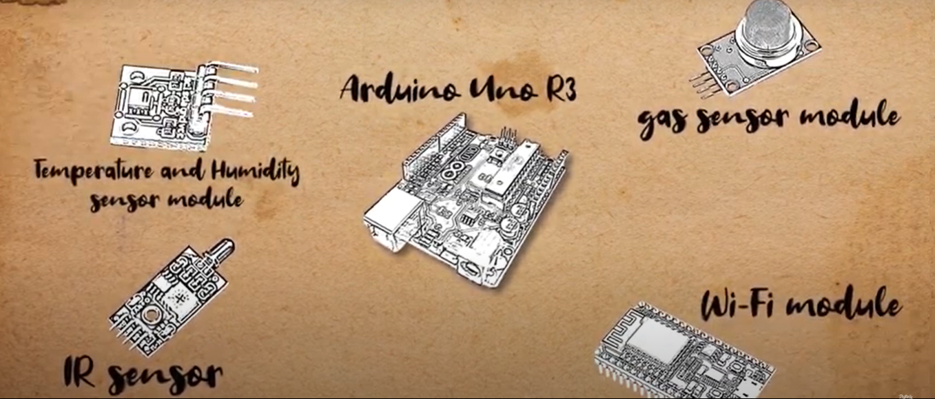
<td height="76" style="height:77px;width:483px;">DetectIT je uređaj za detekciju šumskih požara uz pomoć različitih senzora, koji putem aplikacije šalje obavijest o lokaciji na kojoj je nastao požar.&nbsp;&nbsp;</td> </tr> </tbody> </table>
Digital lösning
Yes
Type av lösning
Sammandrag

Požari u Republici Hrvatskoj predstavljaju veliki problem za šume obzirom da vatrogasne zajednice imaju oko tri tisuće intervencija godišnje. Prosječna površina opožarenog područja godišnje iznosi 14.278 ha. DetectIT pruža informacije o trenutnom stanju na određenom šumskom području na kojem je postavljen uređaj (stupanj temperature, razina vlažnosti te ugljičnog monoksida). Uređaj pruža korisnicima brze informacije o pojavi požara i druge važne informacije.

Uređaji su postavljeni u šumi na 100-300 metara udaljenosti i međusobno komuniciraju pomoću radio valova. Komunikacija između uređaja može biti i do nekoliko kilometara tako da je moguće uređajem pokriti veliko područje. Uređaj ima jedan ili više senzora pomoću kojih uređaj detektira povećanu razinu zapaljivog plina ili dima i šalje signal drugom uređaju o pojavi požara.

Trenutno za slanje obavijesti o pojavi požara uređaj koristi 4G  mrežu. U budućnosti za slanje obavijesti planira se korištenje 5G  mreže koja može poslati obavijest u još kraćem vremenskom razdoblju. Također, planira se proširenje namjene uređaja, tj. postavljanje uređaja u kućanstvima. Prototip uređaja instaliran je i testiran na šumskom području.

Uređaj su razvili srednjoškolci Gimnazije Velika Gorica, Hrvatska. Grupa učenika prijavila se na međunarodno natjecanje i osvojila 2. mjesto. 

Ägare eller författarorganisation
Gimnazija Velika Gorica
Rapportör
Centar kompetencija d.o.o. za istraživanje i razvoj
Namn på rapportören
dr.sc. Ivan Ambroš
E-post till rapportören
Titel resurs 1
Prikaz aplikacije
Huvudbild
Huvudbildens bildtext
Glavne komponente DetectIT uređaja
Logo för best practice
Enkel implementering - Utvärdering
Easy
Nav
South-Eastern Hub
BP - Rosewood - V1
NO
Hållbarhets potential - Värde
Very Positive
Upphovsland
Kroatien
Projekt som detta factsheet skapats inom
Typ av evenemang där denna BPI har presenterats
Title of the event (Study visit - T2.3)
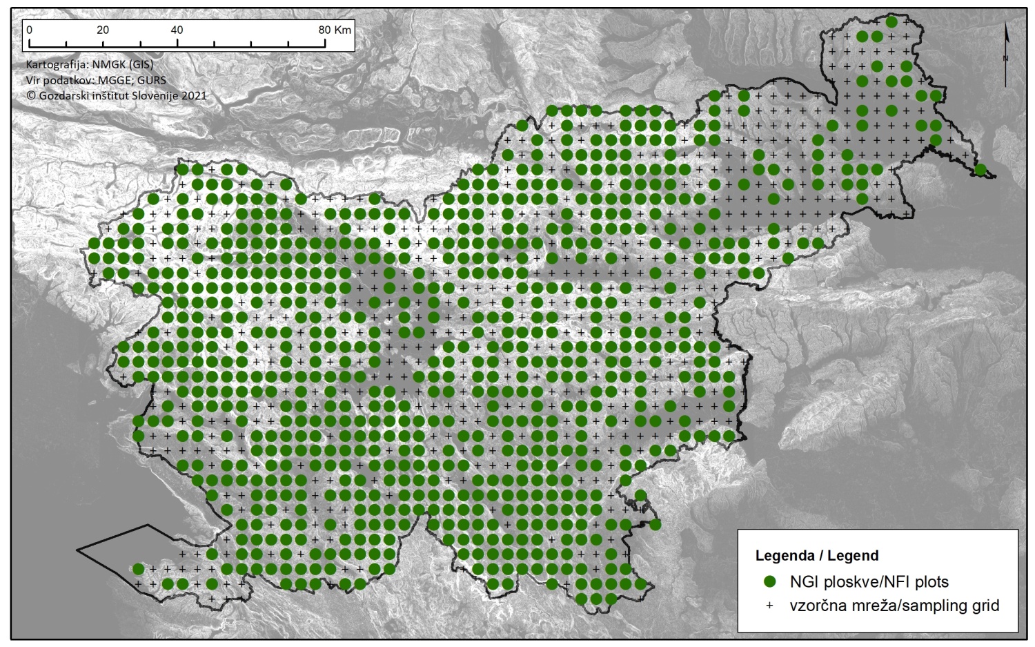
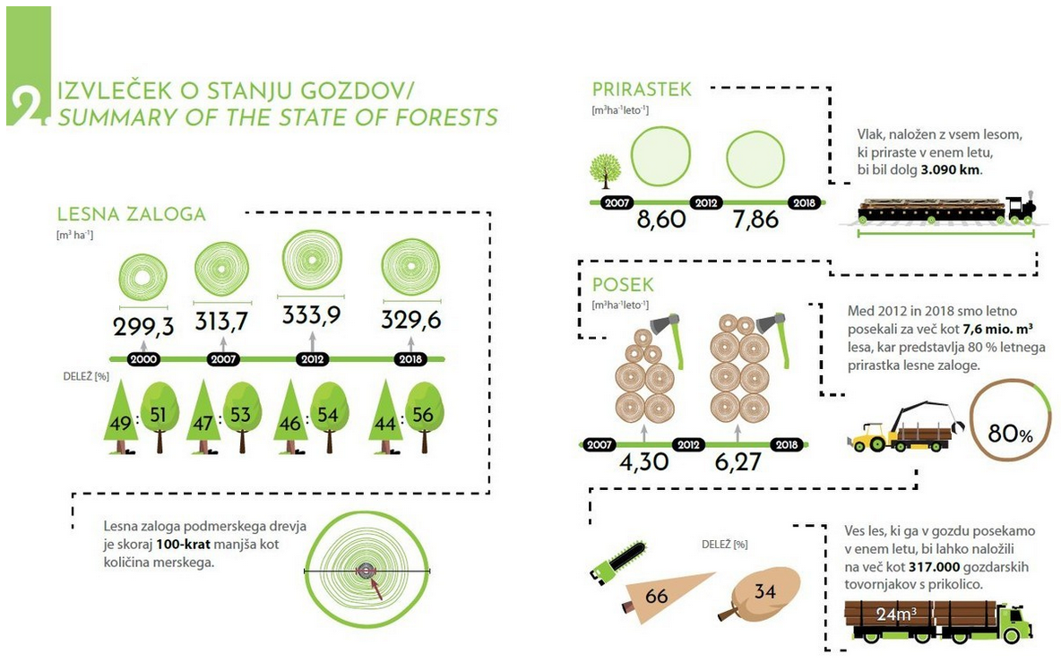
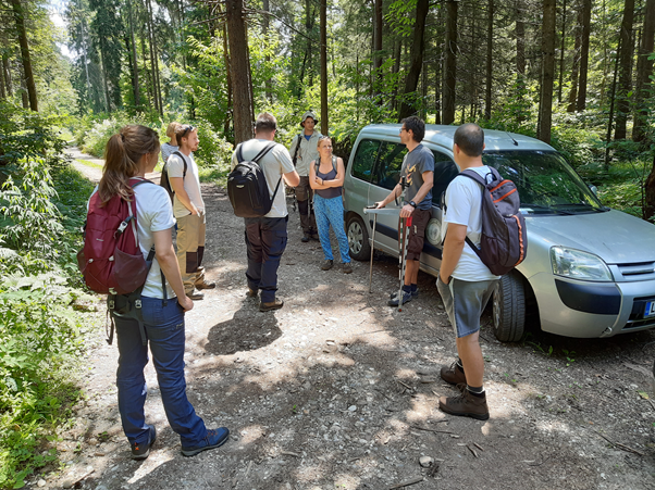
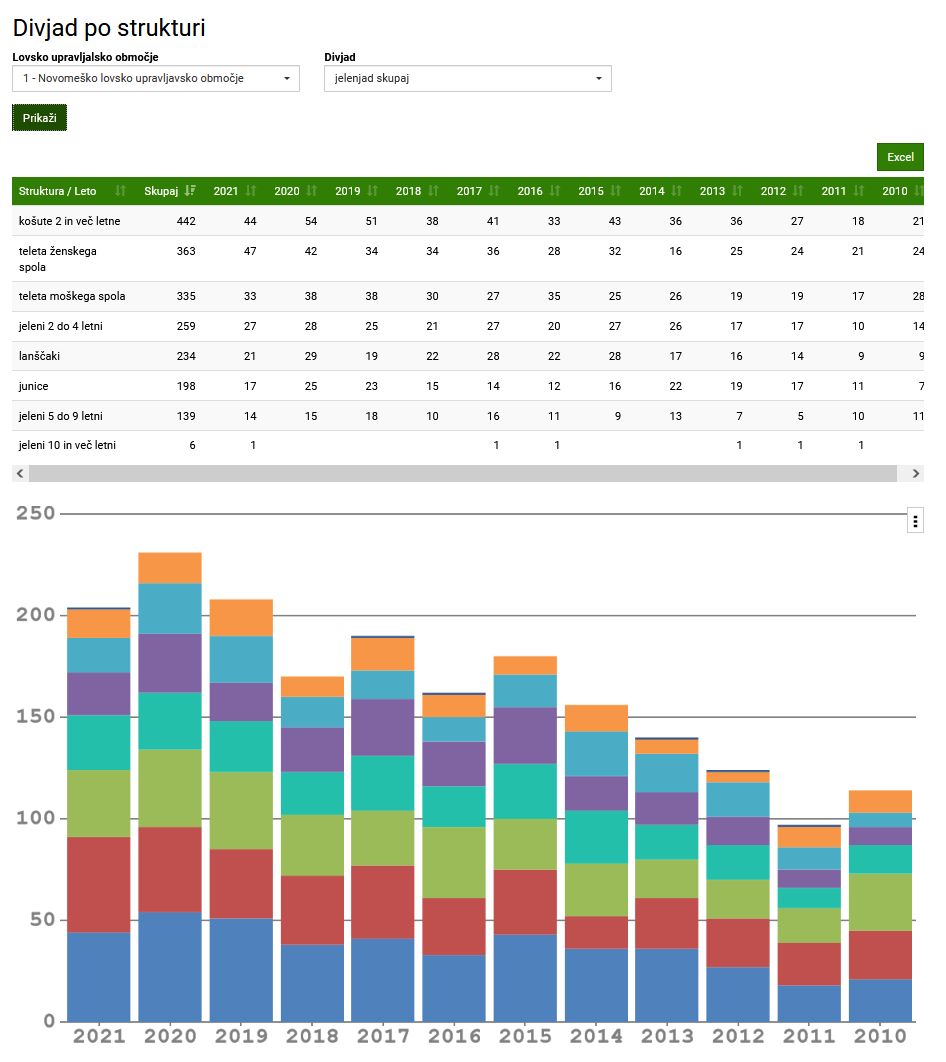
2. studijsko putovanje Centra za jugoistočnu Europu
Rosewood Video
Watch video
DetectIT
Har video
yes
Engelska
Innovasion
Yes
Voting
0%
Startår
2019
Kort beskrivning
<table border="0" cellpadding="0" cellspacing="0" style="width:503px;" width="503"> <tbody> <tr height="76"> <td height="76" style="height:77px;width:503px;">DecectIT is forest fire detection device which detects fire by using different sensors and sends nottification to the application.</td> </tr> </tbody> </table>
Digital lösning
Yes
Sammandrag

Fires in the Republic of Croatia are a big problem for forests, given that fire brigades have about 3.000 interventions per year. Average burned area per year is 14.278 ha of forest land. DetectIT provides information of the current situation in the forest area (level of temperature, humidity, carbon monoxide). Device secures fast information about the occurrence of a fire and provides all important data. Devices are located 100-300 meters away in the forest area and communicate with each other via radio waves. Communication between devices can reach even several kilometers so it is possible to cover very large area. Each device has one or more sensors. When the device receives an icreased concentration of flammable gas or smoke, it sends a signal to the other device about occurrence of a fire.

Currently, for sending notification about occurrence of fire, device uses 4G network. In the future for notification sending, it is planned to use the 5G network which can send notification in a shorter time period. Also, it is planed to spread the use of device i.e. setting device in households. Prototype of device is installed and tested on the forest area. Device is developed by high school students of Gymnasium Velika Gorica, Croatia. Group of students signed up on international competition and won 2nd place. 

Ägare eller författarorganisation
Gymnasium Velika Gorica
Rapportör
Competence Centre Ltd. for research and development
Namn på rapportören
PhD. Ivan Ambroš
E-post till rapportören
Titel resurs 1
Application view
Huvudbild
Huvudbildens bildtext
Main components of DetectIT
Logo för best practice
Enkel implementering - Utvärdering
Easy
Nav
South-Eastern Hub
BP - Rosewood - V1
NO
Hållbarhets potential - Värde
Very Positive
Upphovsland
Kroatien
Projekt som detta factsheet skapats inom
Typ av evenemang där denna BPI har presenterats
Title of the event (Study visit - T2.3)
2nd South-East Europe Hub Study Visit
Rosewood Video
Watch video
DetectIT
Har video
yes
Kroatiska
Country Region City
CroatiaGrad Zagreb
CroatiaOsjecko-baranjska županija
Voting
0%
Startår
2005
Slutår
2015
Kort beskrivning
Katastar zelenila grada je aplikacija koja sadrži popis drveća na određenom području tj. gradu.
Digital lösning
Yes
Type av lösning
Sammandrag

Aplikacija Katastar zelenila grada predstavlja popis drveća na određenom području tj. gradu. Aplikacija sadržava informacije o vrstama i dimenzijama stabala, stanju debla, krošnje i korijena i dokumentaciji o intervalima kontrole drveća. Katastar zelenila grada je razvijen za dva grada u Hrvatskoj, Zagreb i Osijek te je dostupan online. Aplikacija nudi građanima mogućnost fotografiranja stanja na određenom području (osušeno drvo, potrgana klupa, itd.) i slanja informacija nadležnim institucijama kako bi se moglo pravovremeno reagirati. 

Ägare eller författarorganisation
Grad Osijek, Grad Zagreb
Rapportör
Centar kompetencija d.o.o. za istraživanje i razvoj
Namn på rapportören
dr.sc. Ivan Ambroš
E-post till rapportören
Titel resurs 1
Katastar zelenila grada Zagreba
Titel resurs 2
Katastar zelenila grada Osijeka
Huvudbild
Huvudbildens bildtext
Prikaz aplikacije Katastar zelenila grada
Logo, huvudorganisation
Logo Grada Zagreba i Grada Osijeka
Enkel implementering - Utvärdering
Medium
Nav
Central-East Hub
BP - Rosewood - V1
NO
Hållbarhets potential - Värde
Very Positive
Upphovsland
Kroatien
Projekt som detta factsheet skapats inom
Har video
no