Modeliranje, DSS, simulacija, optimizacija

Angleščina
Inovacija
Yes
Source of wood

Woodland/forests

E-naslov lastnika ali avtorja
Code
IN_DE_05
Time scale
Since 2001
Id: 2861876
Continent Code: EU
Country Code: DE
Country Name: Germany
Name: North Rhine-Westphalia
Technical readiness level
Applicable
Location
NRW (Germany)
Implementers
RIF e.V.; RWTH Aachen (MMI); Lehrstuhl für Forstliche Arbeitswissenschaften und Angewandte Informatik & Lehrstuhl für Waldwachstumskunde (TU München); Institut für Roboterforschung (TU Dortmund); CPA-Systems GmbH und Pöyry Management Consulting (Deutschla
Actual status
Running
Country Region City
GermanyNordrhein-Westfalen
Scope
Regional
Voting
0%
Začetek
2001
Digitalne rešitve
Yes
Povzetek

Applications like forest inventory and forestry planning, planning of fellings, optimization of harvesting and accounting processes, improvements of timber logistic, evaluation of damaging events etc. are expecting a realistic virtual illustration of the real forest. Within this project the preconditions for building up a single central database – the Virtual Forest - describing the extensive area of North Rhine-Westphalia are constructed. This database contains a mathematical description of biological and technical aspects of the real forest in different detailing (e.g. forest and single-tree consideration) and different precision. Apart from available terrestrial data and a digital site classification, developed by the Landesbetrieb Wald und Holz NRW, the Virtual Forest is based on remote sensing data and information derived thereof. It applies newly developed algorithms on well-known data formats: for single tree identification laser data and aerial images are used, tree species classification uses images and area segmentation is based on raster and vector data. Thus, a comprehensive survey ranging from inventory to forest growth to logistics can be provided. The Virtual Forest provides all stored data in a new 4D geo-data infrastructure while using standardised interfaces. All data (basic data, derived data, technical data, etc.) can also be used by third (programmes, users). Furthermore, a meta-data catalogue answers questions as “Which data of a certain area and/or to a specific subject are placed in which format, which exactness and which actuality at what costs at which place?” Appropriate safety concepts secure the data access as well as the data itself. The consequent consideration of the factor “time” transforms the 2D- or rather 3D- into a 4D-GIS based on a 4D geo-data infrastructure – the basis for a “time machine”. This enables the user to look at the forest at different (historical or future) conditions. The Virtual Forest serves as a foundation for abstracts of different economy units, which are from case to case both business and economically profitable, and with it for the management of larger amounts of wood at lower costs.

Lastnik ali avtorska organizacija
RIF Institut für Forschung und Transfer e.V.
Poročevalec
InnovaWood asbl
Ime poročevalca
Uwe Kies
E-pošta novinarja
Vir 1 - Naslov
RWTH MMI project website / various demo videos
Glavna slika
Digital twin of forest as central service data platform for multiple forestry actors
Podnapis na glavni sliki
Digital twin of forest as central service data platform for multiple forestry actors
Logotip dobre prakse
Logotip glavne organizacije
Logotip projekta
Dodatna vizualizacija 1
Dodatna vizualizacija 2
Dodatna vizualizacija 3
Izvorna regija
2861876
BP - Rosewood - V1
YES
Izvorna država
Nemčija
Obseg uporabe
Projekt, v okviru katerega so bili zbrani osnovni podatki
Ima videoposnetek
yes
Angleščina
Inovacija
Yes
Source of wood

Woodland/forests

E-naslov lastnika ali avtorja
Code
IN_DE_03
Time scale
Since 2011
Potencial za mobilizacijo
Medium; key advantage is the consulting for forest owners through state foresters especially for concepts for next wood generation
Vrsta obravnavanega lesa
All assortments
Trajnost
Positive
Vpliv na okolje in biodiverziteto

High positive as new tree species according soil and climate are initated

Enostavnost izvedbe
Difficult IT-GIS-System
Gospodarski vpliv
High as there are forest systems stabilized
Vpliv na delovna mesta
Mobilization on whole area
Vpliv na prihodke
Positive
Potrebno specifično znanje
High regards referring IT-System
Stroški izvedbe

Very high investment costs carried out by state

Technical readiness level
Applicable
Ključni predpogoji

Ready to use system for Bavaria state foresters

Location
Bavaria (Germany)
Implementers
INTEND Geoinformatik GmbH
Actual status
Running
Priloge
Country Region City
Germany
Scope
National
Voting
0%
Začetek
2011
Digitalne rešitve
Yes
Izvor lesa
Tip lesa
Povzetek

The overall goal of BayWIS was the construction of a GIS-supported information system which supports the Bavarian Forest Administration in fulfilling their tasks through recording, information, planning and analysis tools.
BayWIS therefore needs to supply and administrate professional forest data with and without special reference together with geo-basic-data and relevant professional data of other offices centrally and redundance-free.
BayWIS is directly connected to the constant optimization of professional task processes.

Qualitative goals of BayWIS are to supply a highly professional, employee-, forest owner-, customer- and citizen-friendly information & communication support. Thereby, the public conception of the completion of tasks of the forest administration is improved and the acceptance through the appliers is increased. Thereby, cost decreasing effects might be possible through the extensive bundling of the information & communication support of all tasks in the forest administration.

In March 2011, the company INTEND Geoinformatik GmbH won the tender for the project with their product WebLine Mobile (WLM). WLM is based on the mobile framework MobileADF of the company ESRI and the Windows Presentation Foundation (WPF).  For BayWIS, WebLine Mobile was extended by an online-component. When using the offline version, the program relies on a local to be synchronized mapcache. In the online version, it uses the direct requests of the map pictures to the ArcGIS server. Therefore, the complete amount of geodata (incl. open geospatial consortium (OGC)-services) is available online in the statewide extent.

Glavna slika
Logotip projekta
BP - Rosewood - V1
YES
Izvorna država
Nemčija
Obseg uporabe
Projekt, v okviru katerega so bili zbrani osnovni podatki
Ima videoposnetek
no
Angleščina
Inovacija
No
Source of wood

Stemwood

E-naslov lastnika ali avtorja
Code
BP_DE_02
Time scale
2009
Potencial za mobilizacijo
Area affected is small but information about advantages of thinnings regarding risks can contribute on a wider level (estimated more than 1 m3/ha)
Vrsta obravnavanega lesa
Stemwood
Trajnost
Medium
Vpliv na okolje in biodiverziteto

Positive on biodiversity and forest resilience enhancement

Id: 2951839
Continent Code: EU
Country Code: DE
Country Name: Germany
Name: Bavaria
Enostavnost izvedbe
Difficult as an expert tool
Gospodarski vpliv
An active learning of different silvicultural approaches for forest owners can be achieved. But cost effects are hardly to describe.
Vpliv na delovna mesta
Better qualified staff through verification and discussion possibilities
Vpliv na prihodke
Positive / more efficient working processes / cost reduction possibility identification
Potrebno specifično znanje
The system is depending on complex program Silva 2.2 – forest experts of TUM have to be included
Stroški izvedbe

Silva 2.2 is not a commercial but a scientific system.

Technical readiness level
Applicable
Ključni predpogoji

Just In cooperation with TUM possible

Location
Tertiäres Hügelland, Bavaria, Germany
Implementers
Fachgebiet für Waldinventur und nachhaltige Nutzung, TU München
Actual status
Closed
Priloge
Country Region City
GermanyBayern
Scope
Regional
Voting
0%
Začetek
2009
Zaključek
2009
Digitalne rešitve
Yes
Izvor lesa
Tip lesa
Povzetek

The basic idea is the processing of natural and financial data for typical forest stands and selected forest treatment alternatives after previous simulation calculations. Thereby, the question initially was limited to the depiction of the alternatives “thinning” or “without thinning”.

This prototype can be complemented with additional indicators; other areas and forest treatment strategies and therefore more data should be added and furthermore more risk integration has to be done

The sorted single tree data then were condensed to coefficients via MS Access queries. The coefficients contain information about the arising amounts of wood of the simulated treatments or rather the timber stock of the remaining stands – sorted into sorts of wood and simulation period. After feeding the data to the consultation support system, a connection to current prices for timber and timber harvesting costs was established. Based on the data from the second National Forest Inventory, the stratification of the area of the Bavarian “Tertiäres Hügelland” and the compilation of simulation stocks was carried out. Using the forest growth simulator Silva 2.2, the simulation stocks were updated once without treatment and once updated according to a thinning scheme. In the next step, the results of the simulation runs (single tree data for the remaining and the outgoing stock) were sorted according to regional sorting criteria using the sorting program BDat 2.0.

Glavna slika
Logotip projekta
Izvorna regija
2951839
BP - Rosewood - V1
YES
Izvorna država
Nemčija
Obseg uporabe
Projekt, v okviru katerega so bili zbrani osnovni podatki
Ima videoposnetek
no
Angleščina
Inovacija
Yes
Source of wood

Stemwood

E-naslov lastnika ali avtorja
Code
IN_FR_06
Time scale
Since 2018
Potencial za mobilizacijo
High potential : increases the volume of wood sold at the time of sale
Vrsta obravnavanega lesa
Stemwood
Trajnost
an online computer system that will eventually replace conventional wood sales
Vpliv na okolje in biodiverziteto

NA

Id: 11071620
Continent Code: EU
Country Code: FR
Country Name: France
Name: Nouvelle-Aquitaine
Enostavnost izvedbe
Medium: creation of new computer tools
Gospodarski vpliv
Purchase of additional wood lots
Vpliv na delovna mesta
NA
Vpliv na prihodke
NA
Potrebno specifično znanje
Partnership with en IT development company
Stroški izvedbe

400 000 €

Technical readiness level
Applicable in the next year
Ključni predpogoji

Need for a mapping tool and a computer tool for use on a tablet

Location
Limousin
Implementers
forest manager, forest owners, wood buyer
Actual status
Started
Priloge
Country Region City
FranceNouvelle-Aquitaine
Scope
Regional
Voting
0%
Začetek
2018
Digitalne rešitve
Yes
Izvor lesa
Tip lesa
Povzetek

The project aims to use new technologies to make the wood sales system economical and dynamic, and to fluidize information to increase wood mobilization and get forest owners involved in management.
Two tools have been developed:
- a computerized wood auction sale system coupled with an online sales platform: SYLVATRADE system
- a digital GIS data sharing platform for optimized management accessible to all stakeholders (owners, managers, buyers) called NEOSYLVAQ.

In the long term, the expert firm Coudert wishes to organise wood sales exclusively online.

The computer sales tool (SYLVATRADE tool) is a platform created from a database to generate standardized batch records and edit contracts. It is associated with the NEOSYLVAQ cartographic platform to give the buyer an overview of the lots, the location and outline of each lot on cartography, access and itineraries and finally facilitates the organization of lot visits.  
At the time of the sale the buyer has several information on the lot on his digital tablet: geographical situation, cadastre, surface, species,... A quasi immediate computer processing makes it possible to display the best offer and its amount to the whole room. The computerized management makes it possible to treat approximately 90 000 m3 of wood in 2 hours. Sales balances can be carried out by computer and quickly by species, volume class, and geographical unit.  The group sales can be followed either remotely on the Internet, or in a room on digital tablets. The results of the offers appear in real time and the contractual documents are published during the sale and are signed electronically at the exit of sale.

Glavna slika
Logotip projekta
Izvorna regija
11071620
BP - Rosewood - V1
YES
Izvorna država
Francija
Obseg uporabe
Projekt, v okviru katerega so bili zbrani osnovni podatki
Ima videoposnetek
no
Angleščina
Inovacija
Yes
Source of wood

Above and below ground woody biomass (wood for fibres, wood for energy)

E-naslov lastnika ali avtorja
Code
IN_FI_02
Time scale
Since 2016
Potencial za mobilizacijo
Not possible to assess.
Vrsta obravnavanega lesa
Above and below ground woody biomass (ex. shrubs, wood for fibres, wood for energy), Stemwood, Industry
Trajnost
Medium (Maximum technical harvesting potentials comply with the sustainable energy wood strategy set by the Finnish government)
Vpliv na okolje in biodiverziteto

Medium (see above)

Enostavnost izvedbe
Easy (the assessment is done by research experts, customers only need to define the basic requirements and calculation area)
Gospodarski vpliv
Positive, helps the customers to plan their business in a more detailed way
Vpliv na delovna mesta
Positive, helps the customers to plan their business in a more detailed way
Vpliv na prihodke
Not possible to assess.
Potrebno specifično znanje
Comprehensive database, coding
Stroški izvedbe

Medium, depending on the size and location of the area.

Technical readiness level
Immediately applicable
Ključni predpogoji

Available on request for the customers in Finland only at the moment.

Location
Rovaniemi, Finland
Implementers
Natural Resources Institute Finland (Luke)
Actual status
Running
Priloge
Country Region City
Finland
Scope
National
Voting
0%
Začetek
2016
Digitalne rešitve
Yes
Izvor lesa
Tip lesa
Povzetek

Spatially explicit GIS-method and a collection of tools to assess the energy wood biomass availability and transport costs at regional level to any given end-use location. In the process the technical harvesting biomass potential, local competing demand and the wood resource balance are assessed. The transport costs from the grid of supply points can be viewed as a function of transport distance. Also, different future growth and demand scenarios can be included into calculations thus providing a valuable decision support to investors of energy wood industry.

Most customer projects differ from every other project in some respect. Calculation methods need more or less adjustment.

Results from the analysis: 1. Numerical (GIS) maps of biomass potential for any given timber assortment, biomass demand and wood resource balance (e.g. balance of small trees, see picture above).
2. Graphs depicting transport costs as a function of distance. 3. Spreadsheets of the result data used for graphs. 4. Summary report of the results for the customers.

For more information, see the reference.

Lastnik ali avtorska organizacija
Natural Resources Institute Finland (Luke)
Ime lastnika ali avtorja
Perttu Anttila
Poročevalec
Natural Resources Institute Finland (Luke)
Ime poročevalca
Vesa Nivala
E-pošta novinarja
Vir 1 - Naslov
Presentation of the Best Practice
Vir 1 - Prenos datoteke
Glavna slika
Logotip glavne organizacije
Logotip projekta
Vozlišče
Northern Hub
BP - Rosewood - V1
YES
Izvorna država
Finska
Obseg uporabe
Projekt, v okviru katerega so bili zbrani osnovni podatki
Ima videoposnetek
no
Angleščina
Inovacija
No
Source of wood

Wood from forests

E-naslov lastnika ali avtorja
Code
BP_ES_07
Time scale
Permanently updated
Potencial za mobilizacijo
-
Vrsta obravnavanega lesa
Any wood from forests
Trajnost
Positive
Vpliv na okolje in biodiverziteto

Positive: reduction on fuel consumption

Id: 3336900
Continent Code: EU
Country Code: ES
Country Name: Spain
Name: Castille and León
Enostavnost izvedbe
Medium
Gospodarski vpliv
Reduction on transportation costs
Vpliv na delovna mesta
None
Vpliv na prihodke
Reduction on transportation costs
Potrebno specifično znanje
GIS and database management
Stroški izvedbe

Depending on existing data

Technical readiness level
Applicable
Ključni predpogoji

Good work planning and suitable personal needed

Location
Castile and Leon
Implementers
Cesefor, Junta de Castilla y León
Actual status
Running
Priloge
Country Region City
SpainCastilla y León
Scope
Regional
Voting
0%
Digitalne rešitve
Yes
Izvor lesa
Tip lesa
Povzetek

Public administrations directly manage a road network on forest land that in many cases is longer than the general road network itself.
Wood transport is a key factor in the value chain of wood mobilization.
There is therefore a need for reliable knowledge of this network, so that resources can be optimised and rationalised in terms of maintenance and improvement, that is to say, the rationalisation of the processes of inventory, planning, programming and control of the work on these tracks must be emphasised.

The lack of digital cartography with sufficient quality in rural areas is a constant in most territories. Together with a certain delay in the application of technologies in the sectors that operate in this area, they make these areas a priority objective on which to concentrate this type of effort.
This cartography allows to plan more effectively the operations related to the harvesting and transport of wood, from the forest to the industry.

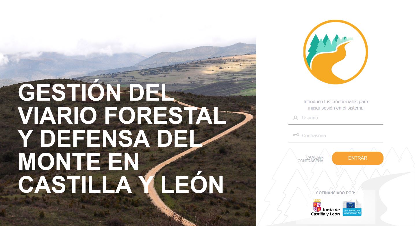
Since 2009, Cesefor has directed and developed the project co-financed by the Regional Government of Castilla y León and the Ministry of Industry and Trade.
Within the framework of this project, more than 50,000 km of rural roads have been inventoried and more than 33,000 equipments have been collected, forming a continuous network connected to the road network with extensive qualitative information on forest areas.
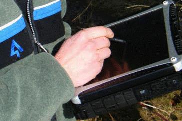
The information has been collected by GPS, attaching the necessary qualitative information in each case.
Specific cartography has been distributed to environmental agents, fire extinguishing media dependent on the Junta de Castilla y León and the digital information is available at the Junta de Castilla y León.
A specific navigator has also been developed for rural roads, since due to the special characteristics of this network it is necessary to know the existing restrictions, either by type of vehicle or state of the tracks.

Glavna slika
Logotip projekta
Izvorna regija
3336900
BP - Rosewood - V1
YES
Izvorna država
Španija
Obseg uporabe
Projekt, v okviru katerega so bili zbrani osnovni podatki
Ima videoposnetek
no