Gojenje gozdov, gospodarjenje z gozdovi, odpornost, ekosistemske storitve

Angleščina
Inovacija
No
E-naslov lastnika ali avtorja
Voting
0%
Začetek
2018
Zaključek
2021
Kratek opis
<table border="0" cellpadding="0" cellspacing="0" style="width:731px;" width="731"> <tbody> <tr height="60"> <td height="60" style="height:60px;width:731px;">The pilot project supports people in using their forests sustainably. The model region of Graz alone shows how great the potential of the Styrian forest stands is.</td> </tr> </tbody> </table>
Digitalne rešitve
No
Povzetek

The preservation of forest functions and the supply of a region with the renewable resource wood require new strategies for forest owners, which they can only implement in cooperation with various partners. Answers to these challenges are to be developed within the framework of this pilot project, for which the political district of "Graz-Umgebung" was selected for Austria, on the basis of a sustainable wood mobilisation chain and climate-fit forest management. Timber mobilisation in private forests means mobilising forest owners and getting them interested in climate-friendly forest management. Because of property protection, additional wood mobilisation can only be achieved in cooperation with the forest owners. An essential step in the project is to point out exemplary small-scale forest managers who have been exploiting their wood utilisation potential for generations in the form of active family forestry. Under the motto "We make our forest climate-fit", active small-scale forest managers are brought into the public eye as climate-fit ambassadors.

The main objectives are:

  • Establish continuity in the support and advice of forest owners
  • Increase wood volumes from the project region
  • Targeted public relations measures in the urban environment to generate a positive perception about the need to manage our forests
  • Establish an advisory and support structure that can be ensured without public funding beyond the project
  • Further development of digital offers for forest owners
Lastnik ali avtorska organizacija
Forst owner association Styria
Ime lastnika ali avtorja
Maximilian Handlos
Poročevalec
Holzcluster Steiermark GmbH
Ime poročevalca
DI Masa Jasarevic
Glavna slika
Logotip glavne organizacije
Logotip projekta
Dodatna vizualizacija 1
BP - Rosewood - V1
NO
Izvorna država
Avstrija
Naslov (nacionalni jezik)
Klimafit- und Holzmobilisierungs-Modellregion Bezirk Graz Umgebung
Obseg uporabe
Projekt, v okviru katerega so bili zbrani osnovni podatki
Ima videoposnetek
no
Angleščina
Inovacija
Yes
E-naslov lastnika ali avtorja
Voting
0%
Naslov (kratica)
reFlex
Digitalne rešitve
Yes
Povzetek
Contactless survey of forest and non-forest ecosystems. Determination of dendrometric parameters of trees, state of forest transport network.
Lastnik ali avtorska organizacija
National Forest Centre - Forest Research Institute
Ime lastnika ali avtorja
Ivan Sačkov
Glavna slika
BP - Rosewood - V1
NO
Obseg uporabe
Projekt, v okviru katerega so bili zbrani osnovni podatki
Ima videoposnetek
no
Angleščina
Inovacija
Yes
E-naslov lastnika ali avtorja
Potencial za mobilizacijo
11000000 m3/y
Vrsta obravnavanega lesa
logwood, primer material
Trajnost
very positive
Vpliv na okolje in biodiverziteto
protection
Enostavnost izvedbe
difficult
Gospodarski vpliv
Transparancy
Vpliv na delovna mesta
minor impact
Vpliv na prihodke
minor impact
Potrebno specifično znanje
Digitalization
Ključni predpogoji
political decision
Voting
0%
Začetek
2021
Kratek opis
<table border="0" cellpadding="0" cellspacing="0" style="width:660px;" width="660"> <tbody> <tr height="477"> <td height="477" style="height:478px;width:660px;">InspectorulPadurii.ro is initiated by Ministry of Environment, Waters and Forests together with the Government of Romania with the aim to make transparent the wood harvesting activity, transport of wood in entire Romania.&nbsp;</td> </tr> </tbody> </table>
Digitalne rešitve
Yes
Tip rešitve
Izvor lesa
Tip lesa
Potencial izkoriščanja
high
Povzetek

 The online portal is an automatic method for identifying illegally cut timber transports from Romania. The users are able to observe alerts from satellites indicating information and once every few days (between 2 and 7 days depending on the satellite) any change in the aerial image associated with the forest vegetation in Romania. The portal also accesses the SUMAL database of the Ministry of Water and Forests in real time. From this database, information is extracted to be processed in the internal system, about the enhancement documents on wood harvests, the locations from where the timber transports are loaded and the information related to these points.The permits on wood harvest became digitalized, therefore all harvesting activity can be checked by satellite monitoring while the transports must obtain a unique code before leaving the place of loading. This code is only obtained after the transport information has been entered into the system, including the location where the code was requested.
The portal, through further developments, also contains an API (set learned of rules), which allows automatic access to all information publicly presented on this portal (layers, transport coordinates and related metadata, enhancement documents, etc.), so that other interested actors can make analyzes that will lead to stopping illegal logging.

Lastnik ali avtorska organizacija
www.mmediu.ro
Ime lastnika ali avtorja
Tanczos Barna, Ministry of Environment, Water and Forests
Poročevalec
ProWood
Ime poročevalca
Kadar Rezso
E-pošta novinarja
Glavna slika
Logotip dobre prakse
Enostavnost izvedbe - Ocenjevanje
Difficult
BP - Rosewood - V1
NO
Trajnost - Vrednost
Very Positive
Naslov (nacionalni jezik)
Radarul Pădurilor
Obseg uporabe
Projekt, v okviru katerega so bili zbrani osnovni podatki
Rosewood Video
Oglejte si videoposnetek
PRO WOOD - Romania's timber tracking system SUMAL 2.0
Ima videoposnetek
yes
Angleščina
Inovacija
Yes
E-naslov lastnika ali avtorja
Voting
0%
Naslov (kratica)
SAT4EST
Kratek opis
<table border="0" cellpadding="0" cellspacing="0" style="width:499px;" width="499"> <tbody> <tr height="60"> <td height="60" style="height:60px;width:499px;">An R&D project aimed at developing a simple, intuitive and cost-effective web-based service to support forest management supervision, integrating remote sensing satellite data with data acquired from other sources.</td> </tr> </tbody> </table>
Digitalne rešitve
Yes
Povzetek

The system consists of four components:

  • remote sensing data - quick access to current and historical data, enabling the user to compare satellite images from different periods;
  • complementary data - cadastral data and detailed forest inventory data from management plans (FMP);
  • remote sensing data products - geometric layers resulting from the processing of satellite images, showing the condition and health status of vegetation and forests;
  • geospatial analyses - juxtaposition of remote sensing data products with cadastral data and detailed forest inventory data, enabling to identify inconsistencies between the actual state of the forest and the state recorded in databases, as well as recent changes.

The entire solution is based on an intuitive map portal for users, which is used to generate various types of maps, including maps of forests and tree cover, forest changes, maps of forest types, maps of forest condition, maps of crown density, maps of aboveground forest biomass and the extent of stand damage due to windstorms, fires, floods and insect infestations. Users of the system have access to current and archival satellite images, and they can compare different types of maps with complementary data as well as upload their own data sets.

Lastnik ali avtorska organizacija
Taxus IT Sp. z o.o.
Ime lastnika ali avtorja
Sylwester Kulik
Poročevalec
Łukasiewicz Research Network - Wood Technology Institute (ITD)
Ime poročevalca
Dobrochna Augustyniak-Wysocka
Referenca projekta
Earth observation based service supporting local administration in non-state forest management (SAT4EST), funded by European Space Agency (ESA) through the Polish Incentive Scheme Programme
Glavna slika
Logotip dobre prakse
Vozlišče
Central-East Hub
BP - Rosewood - V1
NO
Izvorna država
Polska
Naslov (nacionalni jezik)
[PL] System wspierający lokalną administrację w zarządzaniu lasami niepaństwowymi
Obseg uporabe
Projekt, v okviru katerega so bili zbrani osnovni podatki
Ima videoposnetek
no
Angleščina
Inovacija
Yes
E-naslov lastnika ali avtorja
Voting
0%
Začetek
2015
Zaključek
2018
Naslov (kratica)
RemBioFor
Kratek opis
R&amp;D project, which aim is to work out the complex method of defining selected forest stand descriptions as well as aboveground biomass and carbon sequestration, based on the use of remote sensing for the purposes of forest management planning.
Digitalne rešitve
Yes
Povzetek

The aim of the project was to work out the complex method of defining selected forest stand descriptions as well as aboveground biomass and carbon sequestration, based on the use of remote sensing for the purposes of forest management planning.

Among main goals were:

  • acquisition and processing of remote sensing, laboratory and field data,
  • determining the amount of biomass and carbon in the forest based on radar data,
  • development of methods for the inventory of selected stand descriptions, growing stock and biomass with the use of active remote sensing techniques,
  • local correction of dendrometric volume equations based on terrestrial laser scanning data (TLS),
  • development of the merchantable volume conversion factors into biomass and carbon.

Results of the project allow to: reduce time needed to carry out the work of the forest management, especially inventory of growing stock; obtain higher accuracy of the CO2 balance, biomass and annual allowable cut calculations; determine growing stock for any forest area; reduce cost of field work in forest management.

Lastnik ali avtorska organizacija
Instytut Badawczy Leśnictwa
Ime lastnika ali avtorja
Krzysztof Stereńczak
Poročevalec
Łukasiewicz Research Network - Wood Technology Institute (ITD)
Ime poročevalca
Dobrochna Augustyniak-Wysocka
Referenca projekta
Remote sensing based assessment of woody biomass and carbon storage in forests (REMBIOFOR), National Centre for Research and Development within the program „Natural environment, agriculture and forestry” BIOSTRATEG, agreement no. BIOSTRATEG1/267755/4/NCBR/2015
Vir 1 - Naslov
Parkitna K., Krok G., Lisańczuk M., Mitelsztedt K., Ukalski K., Magnussen S., Markiewicz A., Miścicki S., Stereńczak K. 2021. Modelling growing stock volume of forest stands with the use of selected LiDAR Area Based Approaches in various predictive models. Forestry: An International Journal of Forest Research
Glavna slika
Podnapis na glavni sliki
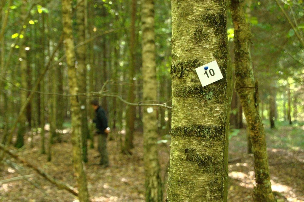
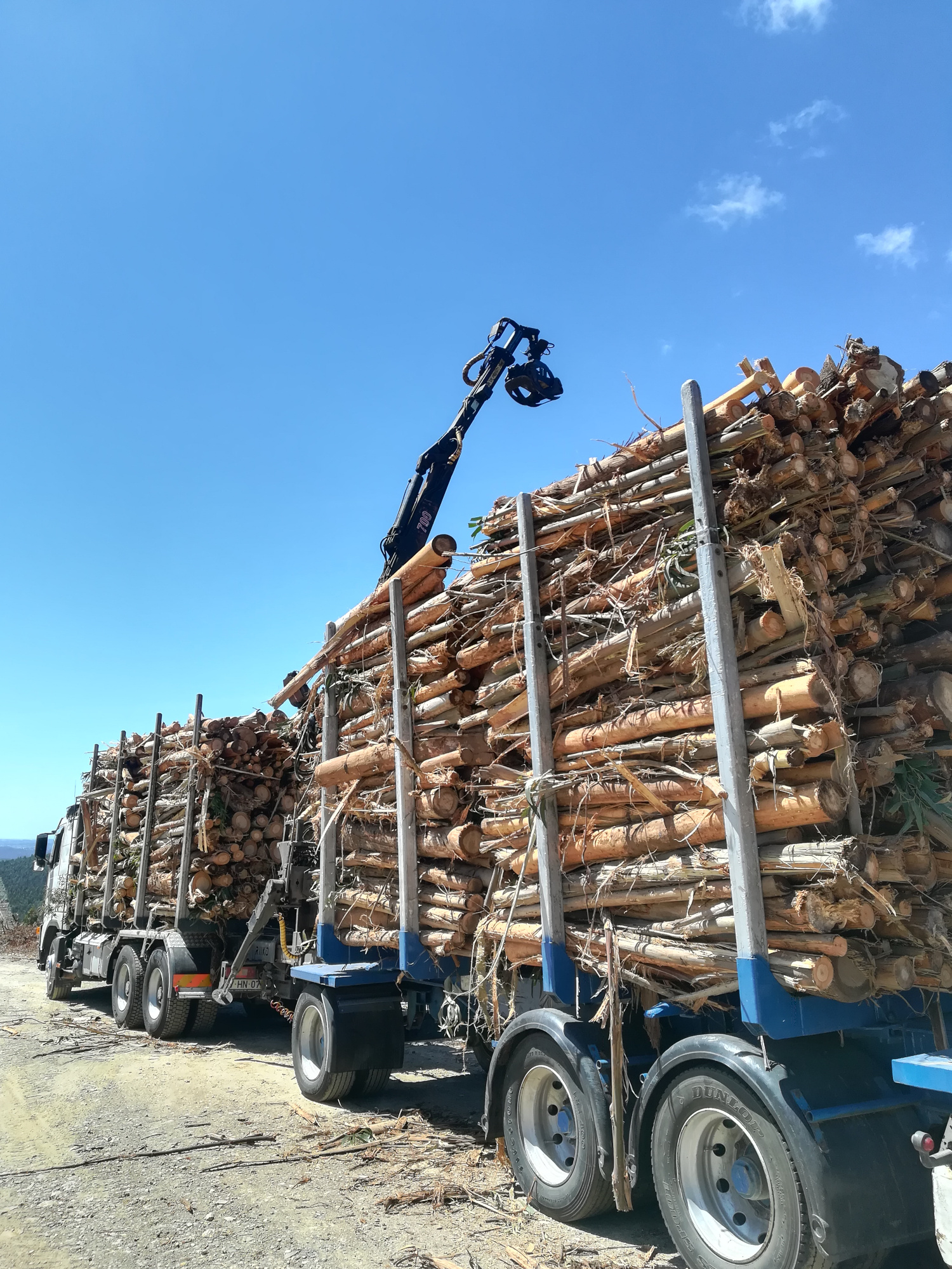
Field work: measurement and acquisition of woody biomass (August - September 2015)
Logotip dobre prakse
Logotip glavne organizacije
Dodatna vizualizacija 1
Vozlišče
Central-East Hub
BP - Rosewood - V1
NO
Izvorna država
Polska
Naslov (nacionalni jezik)
[PL] Teledetekcyjne określanie biomasy drzewnej i zasobów węgla w lasach
Obseg uporabe
Projekt, v okviru katerega so bili zbrani osnovni podatki
Vrsta dogodka, na katerem je bil predstavljen ta BPI
Title of the event (Study visit - T2.3)
Digital Forest Day
Ima videoposnetek
no
Angleščina
Inovacija
Yes
E-naslov lastnika ali avtorja
Voting
0%
Začetek
2018
Kratek opis
Grouping of continuous forest areas to enhance the involvement and motivation of forest owners, and the recognition of the advantages of proper forest management.
Digitalne rešitve
No
Povzetek

Small-size private-owned forest areas are common in Portugal in particular North of the Tagus River. Small patches of forest hinder proper forest management, often leading to increased unmanaged areas more prone to wildfires, pests and diseases. The Baixo Vouga Forest owners association has developed a program of forest area aggregation to tackle this problem by grouping of contiguous areas with the overall aim of facilitating management operations. This will consequently reduce the occurrence of hazards, improve and increase well-managed areas, increase return and motivate investment. To implement the program, at least 5 forest owners with at least 5 properties, summing-up no less than 10 hectares are rquired. Then a GPS-based inventory is carried out and a forest management plan is developed. The program is based on quota-based investments and revenues that will be distributed among those involved with the aim of increasing the engagement, motivation and appreciation of all the agents involved. So far, several areas have been aggregated covering different number of forest owners (e.g. Panasqueira, Águeda, 15 properties belonging to 12 forest owners were aggregated resulting in c.a. 11 thousand ha of forest planted and managed under the same forest management plan) and there are other, more ambitious, still ongoing (e.g. in Lavandeira, Vagos, 211 properties belonging to 138 forest owners were aggregated resulting in c.a. 73 thousand ha).


Lastnik ali avtorska organizacija
Associação Florestal do Baixo Vouga
Ime lastnika ali avtorja
Luís Sarabando
Poročevalec
Instituto Superior de Agronomia (ISA)
Ime poročevalca
Susana Barreiro
E-pošta novinarja
Glavna slika
Logotip glavne organizacije
Dodatna vizualizacija 1
Dodatna vizualizacija 2
Dodatna vizualizacija 3
BP - Rosewood - V1
NO
Izvorna država
Portugalska
Naslov (nacionalni jezik)
Áreas Florestais Agrupadas
Obseg uporabe
Projekt, v okviru katerega so bili zbrani osnovni podatki
Rosewood Video
Oglejte si videoposnetek
Áreas Florestais Agrupadas
Ima videoposnetek
yes
Angleščina
Inovacija
Yes
E-naslov lastnika ali avtorja
Voting
0%
Kratek opis
<table border="0" cellpadding="0" cellspacing="0" style="width:541px;" width="541"> <tbody> <tr height="60"> <td height="60" style="height:60px;width:541px;">Digital solutions designed for more efficient forest workers and stakeholders</td> </tr> </tbody> </table>
Digitalne rešitve
Yes
Povzetek

FeltGis was established in 2016 by three entrepreneurs from the IT and forestry sector with intent to develop easy to use digital solutions for increased efficiency in the forestry value chain. Today the FeltGis team consists of four working partners and are owned by a group of shareholders in an Ltd.  The product FeltBox is a wireless router connecting the forestry machine to the application FeltLog. The FeltLog app makes it possible to transfer information to a computer and to receive data. Two-way communication allows the forestry machine operator to receive work descriptions and to forward production data to the whole value chain. Production data is uploaded to a central database and the user has full control over what data to transfer. FeltBox can easily be installed in any forestry machine regardless of brand, at an affordable price. The system uses access via smartphone to stay updated and to transfer information, no additional internet connection is required. Today 100+ FeltGis solutions are installed in Norway and the same number are installed for testing in different countries. The FeltGis team actively work to develop customized and market-oriented solutions for the national and international market and has concrete plans for developing new innovative solutions in the time to come, expanding their product portfolio in both depth and width. The FeltGis team are currently in dialog with stakeholders from France, Spain, Uruguay, Ireland, and Finland.

Lastnik ali avtorska organizacija
FeltGis A/S
Ime lastnika ali avtorja
CEO. Isak Hasselvold
Poročevalec
Tretorget Ltd
Ime poročevalca
Ola Rostad
E-pošta novinarja
Glavna slika
Logotip glavne organizacije
Dodatna vizualizacija 1
Vozlišče
Northern Hub
BP - Rosewood - V1
NO
Izvorna država
Norveška
Naslov (nacionalni jezik)
FeltGis A/S
Obseg uporabe
Projekt, v okviru katerega so bili zbrani osnovni podatki
Rosewood Video
Ima videoposnetek
yes
Angleščina
Inovacija
Yes
E-naslov lastnika ali avtorja
Voting
0%
Kratek opis
<table border="0" cellpadding="0" cellspacing="0" style="width:512px;" width="512"> <tbody> <tr height="60"> <td height="60" style="height:60px;width:512px;">A lack of forest site information in Styria asks for a new approach to forest site classification and mapping. In this project the forest site classification will be based on a GIS-based geo-ecological stratification model.</td> </tr> </tbody> </table>
Digitalne rešitve
Yes
Povzetek

A lack of forest site information in Styria created a need for a new approach to forest site classification and mapping, considering the changing climatic conditions, which will affect the classification of forest sites and the choice of tree species. Theoretical concepts for a new approach in "dynamic site classification" existed, but the implementation of an integrated site and forest classification in for the whole forest area in Styria has been a scientific challenge. In this project the forest site classification is based on a GIS-based geo-ecological stratification model. The database is based on a digital elevation model, a geological base map, digitally available site and climate data as well as empirical site parameters. A map of forest types is derived based on several thematic maps, including information about energy, water and nutrient balance. Those parameters are modeled on the basis of point and area related data, which are then combined into forest types with a uniform combination of factors. The model allows a stratification of the forest types on all sites based on digital geo-ecological parameters. In addition to the ecological facts, each forest type is characterized by a description of silvicultural guidelines containing information on the appropriate choice of tree species, potential hazards and adaptation methods. These guidelines also describe previous experiences with the tree species and their mixtures, and will provide recommendations for the future forest management with regard to climate change.

Lastnik ali avtorska organizacija
University of Natural Resources and Life Sciences, Vienna (BOKU)
Ime lastnika ali avtorja
Harald Vacik
Poročevalec
Holzcluster Steiermark GmbH
Ime poročevalca
DI Masa Jasarevic
Glavna slika
Logotip dobre prakse
Logotip glavne organizacije
Logotip projekta
BP - Rosewood - V1
NO
Izvorna država
Avstrija
Naslov (nacionalni jezik)
Waldtypisierung Steiermark
Obseg uporabe
Projekt, v okviru katerega so bili zbrani osnovni podatki
Rosewood Video
Oglejte si videoposnetek
FORSITE (Austria) - ROSEWOOD4.0 Best Practice & Innovation
Ima videoposnetek
yes
Španščina
Inovacija
Yes
E-naslov lastnika ali avtorja
Potencial za mobilizacijo
Uno de los casos desarrollados es CAMBRIC: orientado a simular la evolución de las masas forestales y la calidad de la madera en distintos escenarios de gestión forestal.
Vrsta obravnavanega lesa
Madera de masas forestales en riesgo de sufrir un incendio por alta concentración de material combustible, y masas forestales con desarrollo incierto que puede simular esta plataforma.
Trajnost
Alta
Vpliv na okolje in biodiverziteto

Muy alto ya que ayudará a proteger los bosques de los incendios para su mejor gestión.

Enostavnost izvedbe
“Consumir datos abiertos” no es fácil, por lo que resulta necesario crear eslabones intermedios y equipos multidisciplinares que permitan acercar las nuevas tecnologías a los usuarios, para poder diseñar soluciones útiles.
Gospodarski vpliv
Alto, dado que la información facilita la gestión y la previsión de los trabajos forestales que deben realizarse.
Vpliv na delovna mesta
El proyecto no tiene un efecto directo sobre el empleo, pero abre oportunidades para emprendedores y empresas, ya que la información publicada permite que cualquier usuario con el perfil adecuado pueda lanzar consultas y desarrollar herramientas adaptadas
Vpliv na prihodke
No data
Potrebno specifično znanje
Medio, es necesario cierto conocimiento en el manejo de cartografía y herramientas forestales
Stroški izvedbe

Presupuesto:
Total aceptado: 1.637.690 EUR
Contribución total del CEF: 1.228.268,00 (75% de los costes subvencionables)

Ključni predpogoji

La tecnología ya está desarrollada, los requisitos son similares a los necesarios para la utilización de cualquier otro software similar.

Voting
0%
Začetek
2018
Zaključek
2021
Naslov (kratica)
CROSS-FOREST
Kratek opis
Cross-Forest tiene como objetivo publicar conjuntos de datos de inventarios forestales y mapas forestales de Portugal y España en formato Linked Open Data (LOD), y combinarlos para crear e integrar modelos que apoyen la gestión forestal y la protección de los bosques
Digitalne rešitve
Yes
Izvor lesa
Potencial izkoriščanja

Los resultados obtenidos hasta ahora demuestran la utilidad y versatilidad que proporciona la tecnología LOD, ya que permite a los usuarios acceder y gestionar libremente datos actualizados para desarrollar herramientas adaptadas a sus necesidades y propósitos. 

La tecnología LOD permite ir construyendo de forma modular e interconectada una infraestructura de información abierta, pública y de calidad disponible para el sector. Dar continuidad a este tipo de publicación permite a las Administraciones Públicas cumplir con sus obligaciones de transparencia, optimizar recursos y llevar un control estadístico del uso que se hace de la información.


Povzetek

Cross-Forest está desarrollando una plataforma común de datos forestales abiertos y un modelo de datos transfronterizo (ontología) compartido entre Portugal y España, para la publicación de inventarios forestales, mapas y otras bases de datos forestales en formato Linked Open Data (LOD). Cross-Forest proporcionará un repositorio público (endpoint) de publicación de Datos Forestales según el modelo producido. El objetivo principal se centra en mantener la información forestal siempre disponible y actualizada para facilitar su explotación a todos los agentes implicados en la gestión e investigación forestal.

Se están desarrollando dos casos de uso:
CAMBRIC - orientado a simular la evolución de las masas forestales y la calidad de la madera en distintos escenarios de gestión forestal.
FRAME – enfocado a la predicción del comportamiento y propagación de los incendios forestales a través de información precisa sobre materiales combustibles, mapas forestales y modelos de propagación.

Se emplean recursos de computación de alto rendimiento (HPC) debido a la cantidad de datos generados y gestionados, y a la complejidad de los modelos.

Los resultados obtenidos hasta ahora demuestran la utilidad y versatilidad que proporciona la tecnología LOD, ya que permite a los usuarios acceder y gestionar libremente datos actualizados para desarrollar herramientas adaptadas a sus necesidades y propósitos. La publicación de datos como LOD permite a las Administraciones Públicas cumplir fácilmente con sus requisitos de transparencia y publicidad, optimizar recursos y llevar un control estadístico del uso de los datos públicos.


Lastnik ali avtorska organizacija
Grupo Tragsa
Ime lastnika ali avtorja
Asunción Roldan Zamarrón
Poročevalec
Fundación Cesefor
Ime poročevalca
Ángela García
E-pošta novinarja
Referenca projekta
Cross-Forest está cofinanciado por la Agencia Ejecutiva de Innovación y Redes (INEA) de la Unión Europea, a través del Mecanismo Conectar Europa (CEF) 2014-2020. Acción 2017-EU-IA-0140 (Acuerdo nº INEA/CEF/ICT/A2017/1566738)
Glavna slika
Logotip dobre prakse
Logotip glavne organizacije
Logotip projekta
Stroški izvedbe (Euro - €)
1.00 €
Enostavnost izvedbe - Ocenjevanje
Very difficult
Vozlišče
South-Western Hub
BP - Rosewood - V1
NO
Trajnost - Vrednost
Very Positive
Izvorna država
Španija
Portugalska
Projekt, v okviru katerega so bili zbrani osnovni podatki
Ima videoposnetek
no
Angleščina
Inovacija
Yes
E-naslov lastnika ali avtorja
Potencial za mobilizacijo
Medium, this tool provides the best information for an appropiate managemnt to avoid forest fires and also for the best mangament, therfore, it will improve the mobilization potential when CrossForest is used for this purpose
Vrsta obravnavanega lesa
Mediterranean forests in Spain and Portugal
Trajnost
Very high
Vpliv na okolje in biodiverziteto

Very high as it will help to protect forests from fires for its best management.

Enostavnost izvedbe
"Consuming open data" is not easy, so it is necessary to create intermediate links and multidisciplinary teams to bring new technologies closer to users, in order to design adapted solutions.
Gospodarski vpliv
High, as the information facilitates the management and forecasting of forestry work to be carried out.
Vpliv na delovna mesta
The project does not have a direct effect on employment, but it opens up opportunities for entrepreneurs and companies, as the information published allows any user with the appropriate profile to launch queries and develop adapted tools.
Vpliv na prihodke
No data
Potrebno specifično znanje
Medium, some knowledge of mapping and forestry tools is necessary.
Stroški izvedbe

Budget:

Total accepted: 1.637.690 EUR

Total CEF contribution: 1.228.268,00 (75% eligible costs)

Ključni predpogoji

The technology is already developed, the requirements are similar to those necessary for the use of any other similar software.

Voting
0%
Začetek
2018
Zaključek
2021
Naslov (kratica)
CROSS-FOREST
Kratek opis
The aim of Cross-Forest is to publish Forest Inventory Datasets and Forestry maps from Portugal and Spain in Linked Open Data (LOD) format, and to combine them to create and integrate models supporting forest management and forest protection.
Digitalne rešitve
Yes
Izvor lesa
Potencial izkoriščanja

The results obtained so far demonstrate the usefulness and versatility provided by LOD technology, as it allows users to freely access and manage up-to-date data to develop tools adapted to their needs and purposes. 

LOD technology allows for the modular and interconnected construction of an open, public and quality information infrastructure available to the sector. The continuity of this type of publication allows public administrations to meet their transparency obligations, optimise resources and keep statistical control of the use made of the information.

Povzetek

Cross-Forest is developing a common platform for open forest data, and a cross-border data model (ontology) shared between Portugal and Spain, for the publication of forest inventories, maps and other forest databases in Linked Open Data format (LOD). Cross-Forest will provide a public endpoint exposing Forest Data, according to the produced model. The main goal is focused on keeping forest information always available and updated, to make exploitation easier for all stakeholders involved in forest management and research.
Two use cases are being developed:
CAMBRIC - to estimate the evolution of forests and wood quality, under different management scenarios
FRAME - to predict forest fires behavior and spreading through precise information on combustible materials, forestry maps and propagation models.
High Performance Computing (HPC) resources are employed due to the amount of data generated and managed, and to the complexity of the models.
Results so far show the usefulness and versatility provided by LOD technology, as It allows users to freely access and manage updated data to develop tools adapted to their needs and purposes. Publishing data as LOD allows Public Administrations to easily fulfil their requirements of transparence and publicity, optimize resources and keep a statistic control of the use of public data.

Lastnik ali avtorska organizacija
Grupo Tragsa
Ime lastnika ali avtorja
Asunción Roldan Zamarrón
Poročevalec
Cesefor Foundation
Ime poročevalca
Ángela García
E-pošta novinarja
Referenca projekta
Cross-Forest is co-financed by the European Union’s Innovation and Networks Executive Agency (INEA), through the Connecting Europe Facility (CEF) 2014-2020. Action 2017-EU-IA-0140 (Agreement No INEA/CEF/ICT/A2017/1566738)
Glavna slika
Podnapis na glavni sliki
Cross-Forest logo
Logotip dobre prakse
Logotip glavne organizacije
Logotip projekta
Vozlišče
South-Western Hub
BP - Rosewood - V1
NO
Trajnost - Vrednost
Very Positive
Izvorna država
Portugalska
Španija
Naslov (nacionalni jezik)
Armonización CROSS & modelización HPC de datos forestales
Projekt, v okviru katerega so bili zbrani osnovni podatki
Ima videoposnetek
no