Monitoring: Road Condition; Unpaved

×

Komunikat o błędzie

Notice: Undefined index: #markup w bootstrap_preprocess_field() (linia 92 z /data/www/rosewood.admin.v4/sites/all/themes/bootstrap/template.php).
Angielski
Innowacja
Yes
Właściciel lub autor e-mail
Voting
0%
Krótki opis
<table border="0" cellpadding="0" cellspacing="0" style="width:601px;" width="601"> <tbody> <tr height="60"> 
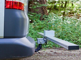
<td height="60" style="height:60px;width:601px;">Mounted at the towing hitch, sensor values are collected and the road quality of unpaved, single lane roads gets assesd. Ultrasonic sensors (cross section scan of a road segment) acceleration sensors to assess the longitudinal roughness and a GPS sensor for locatiion.&nbsp;</td> </tr> </tbody> </table>
Rozwiązanie cyfrowe
Yes
Abstrakt

Scanner is under constant development. A measuring device, mounted at the towing hitch of a car. Sensors collect values, to assess the road quality of unpaved, single lane roads. The system consists of ultrasonic sensors to scan the cross section of a road segment, acceleration sensors to get information about the longitudinal roughness and a GPS sensor for locating the information. After data collection, an open configurable software bundle (implemented as GUI modules in iFOS) allows individual settings for the single sensor thresholds and algorithms to adopt the system to the own road maintenance concept. Mounted at the car of the forest ranger an easy and frequent data collection is possible and provides an early and objective knowledge about the constructional decline of road segments. Maintenance costs can  be reduced and reconstruction measures get execute mor accurate.  A logical data interpretation of the sensor values is possible. The assignment of the sensors towards different decay expressions on the road surface was conducted and semi- automatically related to road quality segment classification. Results show, that a single manual optical assessment of road segments miss first phases of road decay and underlines the potential of such systems. Tests and calibrations of the road-scanner allows a good data interpretation for the set task. Many degrees of freedom of the scanner and the data interpretation still leaves some open research questions.

Właściciel lub organizacja autorska
Thüringenforst
Właściciel lub twórca
Sergej Chmara
Organizacja reporterska
BFH Berne University of Applied Sciences
Osoba przygotowująca fiszkę
Moritz Dreher
Materiał dodatkowy 1 - tytuł
FORMEC conference paper (2016)
Materiał dodatkowy 1 - wgraj plik
Zdjęcie główne
BP - Rosewood - V1
NO
Kraj pochodzenia
Niemcy
Szwajcaria
Tytuł (w języku narodowym)
Messlanze
Skala aplikacji
Projekt, w ramach którego stworzona została niniejsza fiszka
Posiada wideo
no