2. Poprawa infrastruktury i potencjału instytucji publicznych

×

Komunikat o błędzie

Notice: Undefined index: #markup in bootstrap_preprocess_field() (line 92 of /data/www/rosewood.admin.v4/sites/all/themes/bootstrap/template.php).
Angielski
Innowacja
Yes
Właściciel lub autor e-mail
Voting
0%
Tytuł (akronim)
FINT-CH
Krótki opis
<table border="0" cellpadding="0" cellspacing="0" style="width:600px;" width="600"> <tbody> <tr height="60"> <td height="60" style="height:60px;width:600px;">In the project FINT-CH a methodology for the large-scale characterization of forest structures, thereon a better detection of single trees on the basis of remote sensing data, is under development. Top height, cover and mixture ratio get determined.&nbsp;</td> </tr> </tbody> </table>
Rozwiązanie cyfrowe
Yes
Abstrakt
In the project FINT-CH a methodology for the large-scale characterization of forest structures, thereon a better detection of single trees on the basis of remote sensing data, is under development. By using segmentation, stand boundaries and the corresponding top height, cover and mixture ratio get determined. This forms the basis for the specific single tree detection using forest structures. Large-scale geodata with valuable forest information can be generated. Their usage in practice are demonstrated on the basis of four examples.Vector-geodata (type polygon) with stand boundaries and the following attributes:
- Basic shape (uniform, unequally)
- Top height (hdom)
- Cover ratio
- Mixture ratio
- Stem number of upper-class trees
- Basal area of upper-class trees                   Vector-geodata (type points) with detected single trees and the following attributes:
- Top height
- BHD
- Social status in the upper-class
-Z-trees

Vector-geodata (type polygon) with forest gaps, boundaries and aisle                                                  The methodology should be able to get a simple and large-scale investigation every 5 to 10 years regarding the mentioned data attributes mentioned beforehand. With these attributes conclusions are possible regarding stem numbers of different classes, protective forest investigations, mapping of forest gaps, boundaries and aisle as well as on stock estimations and finally operational planning (allowable cut, activity planning… )

Właściciel lub organizacja autorska
BFH Bern University of Applied Sciences
Właściciel lub twórca
Luuk Dorren
Organizacja reporterska
BFH Berne University of Applied Sciences
Osoba przygotowująca fiszkę
Moritz Dreher
Zdjęcie główne
BP - Rosewood - V1
NO
Kraj pochodzenia
Szwajcaria
Tytuł (w języku narodowym)
Einzelbaumerkennung
Skala aplikacji
Projekt, w ramach którego stworzona została niniejsza fiszka
Posiada wideo
no
Angielski
Innowacja
Yes
Właściciel lub autor e-mail
Voting
0%
Rok rozpoczęcia
2009
Krótki opis
<table border="0" cellpadding="0" cellspacing="0" style="width:499px;" width="499"> <tbody> <tr height="100"> 
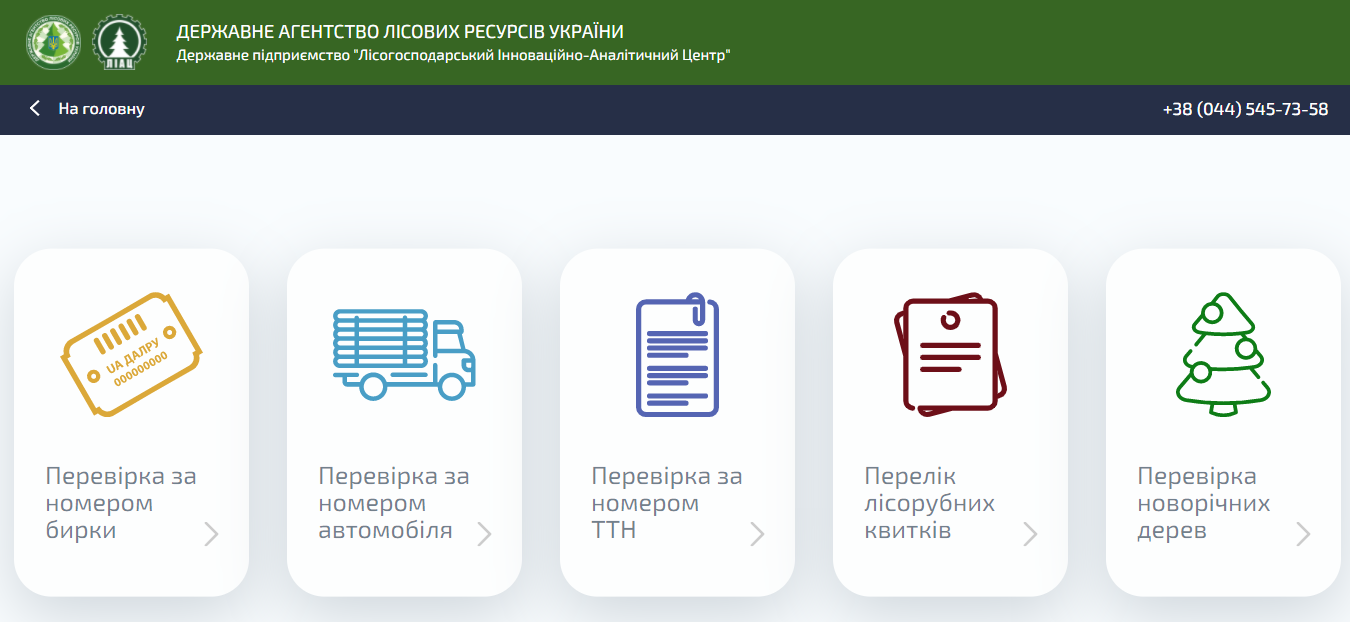
<td height="100" style="height:101px;width:499px;">A single electronic register of Ukrainian timber. The system enables to track the timber origin and it represents digitally the supply chain from forest to the buyer at the first processing facility.</td> </tr> </tbody> </table>
Rozwiązanie cyfrowe
Yes
Rodzaj rozwiązania
Abstrakt

Electronic timber tracking is a single electronic register of Ukrainian timber. Permanent forest users are obliged to electronically tag each log (or in case of firewood each batch) enabling to establish the legality of its harvesting, namely: description of the log, place and time, name of the team that carried out the procurement, transport document. Thus the system digitally represents the supply chain from forest to the buyer at the first processing facility. Electronic timber accounting has been implemented in Ukraine in phases since 2009, and is still running. At first the system was used only by permanent users under the State Agency of Forest Resources of Ukraine (SFRA) and since 2020 it becomes obligatory to all permanent forest users in Ukraine. 

Technology, equipment and software come from Latchbacher (AT) and are adapted to the Ukrainian conditions. For foresters, as key users, the system decreases the time to register, process and report on sales of unprocessed timber. At the same time, it is also freely accessible for the general public on the website. Anyone can track the legality of timber origin knowing the number of the tag, or invoice number, or truck license plate. As of December 2019 electronic timber tracking is carried out by 504 enterprises (incl. 297 enterprises of the SFRA). Ministries and agencies are also connected to the system for control and information exchange purposes. In total, more than 3,700 mobile users are connected.  

Właściciel lub organizacja autorska
State Enterprise "Forestry Innovation and Analytical Center"
Właściciel lub twórca
Yuriy Sotnyk
Organizacja reporterska
NGO FORZA
Osoba przygotowująca fiszkę
Lesya Loyko
E-mail reportera
Materiał dodatkowy 1 - tytuł
Overview of Electronic Tracking of Timber in Ukraine given in the World Bank Ukraine country forest note, 2020
Zdjęcie główne
Logo organizacji
Logo projektu
BP - Rosewood - V1
NO
Kraj pochodzenia
Ukraina
Tytuł (w języku narodowym)
Електронний облік деревини
Skala aplikacji
Projekt, w ramach którego stworzona została niniejsza fiszka
Rosewood Video
Obejrzyj wideo
Electronic Timber Tracking (Ukraine)
Posiada wideo
yes
Angielski
Innowacja
Yes
Właściciel lub autor e-mail
Voting
0%
Tytuł (akronim)
SAT4EST
Krótki opis
<table border="0" cellpadding="0" cellspacing="0" style="width:499px;" width="499"> <tbody> <tr height="60"> <td height="60" style="height:60px;width:499px;">An R&D project aimed at developing a simple, intuitive and cost-effective web-based service to support forest management supervision, integrating remote sensing satellite data with data acquired from other sources.</td> </tr> </tbody> </table>
Rozwiązanie cyfrowe
Yes
Abstrakt

The system consists of four components:

  • remote sensing data - quick access to current and historical data, enabling the user to compare satellite images from different periods;
  • complementary data - cadastral data and detailed forest inventory data from management plans (FMP);
  • remote sensing data products - geometric layers resulting from the processing of satellite images, showing the condition and health status of vegetation and forests;
  • geospatial analyses - juxtaposition of remote sensing data products with cadastral data and detailed forest inventory data, enabling to identify inconsistencies between the actual state of the forest and the state recorded in databases, as well as recent changes.

The entire solution is based on an intuitive map portal for users, which is used to generate various types of maps, including maps of forests and tree cover, forest changes, maps of forest types, maps of forest condition, maps of crown density, maps of aboveground forest biomass and the extent of stand damage due to windstorms, fires, floods and insect infestations. Users of the system have access to current and archival satellite images, and they can compare different types of maps with complementary data as well as upload their own data sets.

Właściciel lub organizacja autorska
Taxus IT Sp. z o.o.
Właściciel lub twórca
Sylwester Kulik
Organizacja reporterska
Łukasiewicz Research Network - Wood Technology Institute (ITD)
Osoba przygotowująca fiszkę
Dobrochna Augustyniak-Wysocka
Projekt
Earth observation based service supporting local administration in non-state forest management (SAT4EST), funded by European Space Agency (ESA) through the Polish Incentive Scheme Programme
Zdjęcie główne
Logo dobrej praktyki
Hub
Central-East Hub
BP - Rosewood - V1
NO
Kraj pochodzenia
Polska
Tytuł (w języku narodowym)
[PL] System wspierający lokalną administrację w zarządzaniu lasami niepaństwowymi
Skala aplikacji
Projekt, w ramach którego stworzona została niniejsza fiszka
Posiada wideo
no
Angielski
Innowacja
Yes
Właściciel lub autor e-mail
Voting
0%
Rok rozpoczęcia
2014
Tytuł (akronim)
LignoSilva INFRA
Krótki opis
LignoSilva is Centre of Excellence of the National Forest Centre in cooperation with the Pulp and Paper Institute with a focus on research and innovation in the field of production, mechanical and chemical processing and use wood utilization, strongly committed to demonstrate innovative digitalization technologies.
Rozwiązanie cyfrowe
Yes
Abstrakt

Based on scientific excellence, outstanding infrastructure, research synergy and cooperation with decision makers and business establishment of the Centre of Excellence of European significance in the field of forestry, wood processing, pulp and paper in cooperation with leading research organisations in the EU. Through implementation of unique infrastructure (3D CT scanner) CoE LignoSilva focus on the innovation development with companies in the field of wood production, processing and utilisation and to contribute to their development and innovation activities related to multi-purpose management of forests; enhanced biomass production; secured wood supply, forest operations and logistics; cascade use, reuse and recycling systems of wood and energy from wood.The fundamental innovative impulse for higher utilization of wood raw material is the implementation of:
• technologies of ground mobile laser scanning for qualitative inventory - assortment of stands.
• 3D CT scanner for the detection of quality and errors of wood and the subsequent use of the obtained data in the field of optimization of sorting and sawmill wood processing.
In the field of pulp and paper processing, CoE's research and innovation activities focus on replacing plastics with biodegradable and compostable packaging based on paper, cardboard and paperboard with special surface treatments.
 

Właściciel lub organizacja autorska
National Forest Centre – Forest Research Institute
Właściciel lub twórca
Tomáš Bucha
Projekt
LignoSilva Centre of Excellence, Horizon 2020 no. 664557
Zdjęcie główne
Logo organizacji
Dodatkowe materiały 1
Dodatkowe materiały 2
BP - Rosewood - V1
NO
Kraj pochodzenia
Słowacja
Skala aplikacji
Projekt, w ramach którego stworzona została niniejsza fiszka
Rosewood Video
Obejrzyj wideo
LignoSilva (Slovakia) - ROSEWOOD4.0 Best Practice & Innovation
Posiada wideo
yes
Angielski
Innowacja
No
Właściciel lub autor e-mail
Główna kategoria
Voting
0%
Tytuł (akronim)
BDL
Krótki opis
<table border="0" cellpadding="0" cellspacing="0" style="width:437px;" width="437"> <tbody> <tr height="60"> <td height="60" style="height:60px;width:437px;">Data warehouse collecting, processing and sharing information concerning forests of all ownership forms in Poland. Data Bank provides both descriptive and geo-referenced spatial data, through web portal and mobile app.</td> </tr> </tbody> </table>
Rozwiązanie cyfrowe
Yes
Rodzaj rozwiązania
Abstrakt

Forest Data Bank is a data warehouse collecting, processing and sharing information concerning forests of all ownership forms in Poland. It’s aims include also supporting scientific research, enabling analysis and forecasting of forest resources and promoting standards of collecting and processing of forest data.

Data Bank provides both descriptive and geo-referenced spatial data. Available data cover forest stand and statistical unit description, forecasting and additional information such as: forest protection, fire protection, nature conservation, environment monitoring, hydrology, climatology, geology, nature and forest regionalisation, forest functional areas, seed regionalisation and National Register of Boundaries.
Forest Data Bank could be accessed through web portal (which includes also reports, publications and maps) or mobile app (mBDL), which offers access to map resources and navigation. Main target group are foresters but it is also used for the purposes of spatial planning, science, public and international statistics, and tourism. It provides information not only at the central level, but also regional and local ones. Data Bank is covering about 95% of forests in Poland (one of the most comprehensive dataset comparing to other countries that own such systems) and there are more than 25 thou visitors on the BDL portal per month.
 

Właściciel lub organizacja autorska
State Forests National Forest Holding
Właściciel lub twórca
State Forests National Forest Holding
Organizacja reporterska
Łukasiewicz Research Network - Wood Technology Institute (ITD)
Osoba przygotowująca fiszkę
Dobrochna Augustyniak-Wysocka
Materiał dodatkowy 1 - tytuł
Best practice - short article
Zdjęcie główne
Hub
Central-East Hub
BP - Rosewood - V1
NO
Kraj pochodzenia
Polska
Tytuł (w języku narodowym)
Bank Danych o Lasach
Skala aplikacji
Projekt, w ramach którego stworzona została niniejsza fiszka
Rosewood Video
Obejrzyj wideo
Forest Data Bank Poland
Posiada wideo
yes
Angielski
Innowacja
Yes
Source of wood

Woodland/forests

Właściciel lub autor e-mail
Code
IN_DE_05
Time scale
Since 2001
Id: 2861876
Continent Code: EU
Country Code: DE
Country Name: Germany
Name: North Rhine-Westphalia
Technical readiness level
Applicable
Location
NRW (Germany)
Implementers
RIF e.V.; RWTH Aachen (MMI); Lehrstuhl für Forstliche Arbeitswissenschaften und Angewandte Informatik & Lehrstuhl für Waldwachstumskunde (TU München); Institut für Roboterforschung (TU Dortmund); CPA-Systems GmbH und Pöyry Management Consulting (Deutschla
Actual status
Running
Country Region City
GermanyNordrhein-Westfalen
Scope
Regional
Voting
0%
Rok rozpoczęcia
2001
Rozwiązanie cyfrowe
Yes
Abstrakt

Applications like forest inventory and forestry planning, planning of fellings, optimization of harvesting and accounting processes, improvements of timber logistic, evaluation of damaging events etc. are expecting a realistic virtual illustration of the real forest. Within this project the preconditions for building up a single central database – the Virtual Forest - describing the extensive area of North Rhine-Westphalia are constructed. This database contains a mathematical description of biological and technical aspects of the real forest in different detailing (e.g. forest and single-tree consideration) and different precision. Apart from available terrestrial data and a digital site classification, developed by the Landesbetrieb Wald und Holz NRW, the Virtual Forest is based on remote sensing data and information derived thereof. It applies newly developed algorithms on well-known data formats: for single tree identification laser data and aerial images are used, tree species classification uses images and area segmentation is based on raster and vector data. Thus, a comprehensive survey ranging from inventory to forest growth to logistics can be provided. The Virtual Forest provides all stored data in a new 4D geo-data infrastructure while using standardised interfaces. All data (basic data, derived data, technical data, etc.) can also be used by third (programmes, users). Furthermore, a meta-data catalogue answers questions as “Which data of a certain area and/or to a specific subject are placed in which format, which exactness and which actuality at what costs at which place?” Appropriate safety concepts secure the data access as well as the data itself. The consequent consideration of the factor “time” transforms the 2D- or rather 3D- into a 4D-GIS based on a 4D geo-data infrastructure – the basis for a “time machine”. This enables the user to look at the forest at different (historical or future) conditions. The Virtual Forest serves as a foundation for abstracts of different economy units, which are from case to case both business and economically profitable, and with it for the management of larger amounts of wood at lower costs.

Właściciel lub organizacja autorska
RIF Institut für Forschung und Transfer e.V.
Organizacja reporterska
InnovaWood asbl
Osoba przygotowująca fiszkę
Uwe Kies
E-mail reportera
Materiał dodatkowy 1 - tytuł
RWTH MMI project website / various demo videos
Zdjęcie główne
Digital twin of forest as central service data platform for multiple forestry actors
Podpis pod zdjęciem głównym
Digital twin of forest as central service data platform for multiple forestry actors
Logo dobrej praktyki
Logo organizacji
Logo projektu
Dodatkowe materiały 1
Dodatkowe materiały 2
Dodatkowe materiały 3
Region pochodzenia
2861876
BP - Rosewood - V1
YES
Kraj pochodzenia
Niemcy
Skala aplikacji
Projekt, w ramach którego stworzona została niniejsza fiszka
Posiada wideo
yes
Angielski
Innowacja
No
Source of wood

Stemwood, energy wood

Code
BP_FI_05
Time scale
Long history
Potencjał dla mobilizacji drewna
High
Rodzaj drewna
Stemwood, energy wood
Potencjał dla zrównoważonego rozwoju
Positive
Wpływ na środowisko i bioróżnorodność

Might have effected to environment: species and water environments

Łatwość wdrożenia
Easy
Wpływ na gospodarkę
Enabling wood procurement: easier access to forest resources.
Efekty w zakresie zatrudnienia
Positive
Efekty ekonomiczne
Positive
Wymagana wiedza specjalistyczna
"Skills inb forest road planning and construction Planning of maintenance"
Koszt implementacji

High

Technical readiness level
Applicable
Kluczowe wymagania

Participation of each relevant stakeholders.

Location
Finland
Implementers
Private forests, state forests
Actual status
Running
Załączniki
Country Region City
Finland
Scope
National
Voting
0%
Rozwiązanie cyfrowe
No
Pochodzenie surowca drzewnego
Rodzaj surowca drzewnego
Abstrakt

The Finnish forest road network (150 000 km) gives value not only to forestry but enhances recreational utilization of forests and serves for preventing forest fires and for rescue services. It contributes also to putting out fires if needed. Half of the private roads in Finland are forest roads. Forest roads allow access to forest assets allover Finland.
The forest road networks enable efficient wood procurement from forests. Access to forests are easier and the long-distance transportation is simple. Distances to forests are shorter and in the countryside, forest roads are used for other transportation as well and as links between villages. The recreational users (berry picking, hunting) benefit from roads also.

It is important to keep the road clear of bushes and prevent water from resting on the road. Heavy vehicles are not allowed to utilize the roads during frost heave. Constant maintenance of forest road network and the connected road networks and bridges would be essential, since roads have been built lightly and cost-efficiently.
In the forest road maintenance, utilization of side steams from forest industry, heat plants and mines, for example, would advance actions or circular economy and contribute to preventing emissions and waste.
Heavier vehicles require constant maintenance of forest roads. New method for maintenance need to be applied as well. Mild winters and rainy summers add to the need for maintenance.

Zdjęcie główne
Podpis pod zdjęciem głównym
Finnish Forest Road (Photo: Yle)
Logo projektu
Hub
Northern Hub
BP - Rosewood - V1
YES
Kraj pochodzenia
Finlandia
Skala aplikacji
Projekt, w ramach którego stworzona została niniejsza fiszka
Posiada wideo
no
Angielski
Innowacja
Yes
Source of wood

Stemwood, energy wood

Właściciel lub autor e-mail
Code
BP_FI_01
Time scale
Running
Potencjał dla mobilizacji drewna
Not possibile to assess
Rodzaj drewna
Stemwood, energy wood
Potencjał dla zrównoważonego rozwoju
High
Wpływ na środowisko i bioróżnorodność

Positive: less waste from production side streams

Łatwość wdrożenia
Easy
Wpływ na gospodarkę
Positive
Efekty w zakresie zatrudnienia
New business from utilization of side streams and waste
Efekty ekonomiczne
Positive
Wymagana wiedza specjalistyczna
Knowledge, research and testing of special mixtures
Koszt implementacji

Low

Technical readiness level
Applicable
Kluczowe wymagania

Information about side streams from mines and forest industry
Information about usability of side streams in road infrastructure

Location
Pohjois- ja Itä-Suomi
Implementers
Tapio Ltd
Actual status
Running
Załączniki
Scope
Regional
Voting
60%
Rozwiązanie cyfrowe
No
Pochodzenie surowca drzewnego
Rodzaj surowca drzewnego
Abstrakt

The ashes can be used in a road building among gravel. The use of ash from neighboring heat plants reduces the use of natural aggregates. The use of ash in the construction of the road has been limited, as it is currently subject to environmental permits.
In the forest and energy industries, burning wood produces a lot of ash, which is placed in landfills. The forest industry alone generates more than 300 000 tonnes of exploeable ash every year. The increase in wood energy increases the amount of ash even further. Current measures to benefit from the use of ash do not correspond to the principles of sustainable consumption and production. It would be essential to influence the legislation in order to ease the utilization of ash. It is important to perform carrying capacity measurements and research and test different mixtures of gravel and ash. The environmental issues need to be surveyed.

In Finland there are 135 000 km of forest roads where maintenance is necessary for wood procurement. According to the National Forest Programme 2015, forest car roads should be upgraded to 4 000 km annually. In the construction of roads, cost-effectiveness is most essential. The biggest challenge in most cases is the availability of affordable gravel or crushing near the forest road project. Utilization of ash as material for road construction and maintenance has produced excellent results in terms of both the technical suitability and the environmental impact.

Właściciel lub organizacja autorska
Tapio Oy
Właściciel lub twórca
Samuli Joensuu
Zdjęcie główne
Logo projektu
Dodatkowe materiały 1
Dodatkowe materiały 2
Hub
Northern Hub
BP - Rosewood - V1
YES
Kraj pochodzenia
Finlandia
Skala aplikacji
Projekt, w ramach którego stworzona została niniejsza fiszka
Posiada wideo
yes