1. Poprawa odporności lasu i adaptacja do zmian klimatu

Portugalski, Portugalia
Innowacja
Yes
Właściciel lub autor e-mail
Voting
0%
Rok rozpoczęcia
2017
Rok zakończenia
2020
Krótki opis
<table border="0" cellpadding="0" cellspacing="0" style="width:541px;" width="541"> <tbody> <tr height="60"> <td height="60" style="height:60px;width:541px;">Plataforma de apoio técnico-científico à gestão de povoamentos de eucalipto&nbsp;</td> </tr> </tbody> </table>
Rozwiązanie cyfrowe
Yes
Abstrakt

O projeto teve como objetivo a transferência de conhecimento visando incentivar a adoção de boas práticas de gestão de plantações de eucalipto. Neste âmbito foi desenvolvida uma plataforma gratuita e de fácil utilização capaz de fornecer indicações técnicas tendo em conta as características edafoclimáticas e topográficas locais. Para beneficiar da recomendação técnica, o utilizador tem de registar-se na plataforma (versão trial disponível para teste). Primeiro, precisa adicionar a sua propriedade delimitando-a no Google Maps ou importando um shapefile/KML. O passo seguinte consiste na caracterização da propriedade e ocupação (ex. idade, rotação, tipo de solo, topografia). Por fim, resta indicar se se trata de uma nova plantação ou da manutenção de um povoamento existente. Uma vez completados estes passos, a plataforma disponibiliza automaticamente uma prescrição técnica customizada em formato pdf. O utilizador pode acrescentar, eliminar ou editar as suas propriedades e solicitar uma nova prescrição técnica. Em alternativa, o utilizador pode conceder o acesso direto a terceiros (ex. a um gestor florestal). A plataforma permite, ainda, consultar possíveis restrições de âmbito legal e/ou ambiental relacionadas com a prática silvícola na propriedade. A plataforma inclui também uma biblioteca online, entre outros conteúdos. No final de 2021 contava com 3 patentes submetidas, mais de 43k visualizações e 10k utilizadores estando 560 registados no módulo de indicações técnicas.

Właściciel lub organizacja autorska
RAIZ – Instituto de investigação da floresta e papel
Organizacja reporterska
Instituto Superior de Agronomia (ISA)
Osoba przygotowująca fiszkę
Susana Barreiro
E-mail reportera
Zdjęcie główne
Logo dobrej praktyki
Logo organizacji
Dodatkowe materiały 1
Dodatkowe materiały 2
BP - Rosewood - V1
NO
Kraj pochodzenia
Portugalia
Skala aplikacji
Projekt, w ramach którego stworzona została niniejsza fiszka
Posiada wideo
yes
Francuski
Innowacja
Yes
Właściciel lub autor e-mail
Główna kategoria
Voting
0%
Rok rozpoczęcia
2018
Krótki opis
<table border="0" cellpadding="0" cellspacing="0" style="width:451px;" width="450"> <tbody> <tr height="60"> <td height="60" style="height:60px;width:451px;">Climafor est une méthode de calcul de bilan carbone et un logiciel en cours de développement. Il permet de comparer les bilans carbone de deux itinéraires sylvicoles. Il tient compte de la séquestration de carbone par la forêt, le stockage dans le matériau bois et les effets de substitution découlant de l'usage du matériau/énergie provenant du bois plutôt que de sources fossiles.</td> </tr> </tbody> </table>
Rozwiązanie cyfrowe
No
Abstrakt

La prise en compte de l'enjeu carbone dans la gestion forestière prend de plus en plus d'ampleur en France, donnant lieu à des projets de recherche et de développement. Le logiciel Climafor répond à une difficulté: rendre les calculs carbone plus facile d'accès et moins chronophages. Les sources de données utilisées (tables de production, coefficients de calcul) sont aujourd'hui bien connues. Climafor les intègre en un seul outil, qui ne nécessite pas de formation particulière. Les calculs sont instantanés et les résultats utilisables directement dans un projet carbone forestier. Les calculs effectués par le logiciel s'appuient sur des tables de production pour chaque essence et différents coefficients issus de la recherche. Le logiciel sera en amélioration continue par actualisation des différents paramètres et ajout de nouvelles tables. Pour le moment, il est en cours de développement par l'IDF (institut du développement forestier), la branche R&D du CNPF.

Właściciel lub organizacja autorska
CNPF
Właściciel lub twórca
Simon Martel
Osoba przygotowująca fiszkę
Henri Husson
E-mail reportera
Zdjęcie główne
Logo dobrej praktyki
BP - Rosewood - V1
NO
Kraj pochodzenia
Francja
Tytuł (w języku narodowym)
Climafor
Skala aplikacji
Projekt, w ramach którego stworzona została niniejsza fiszka
Posiada wideo
no
Angielski
Innowacja
Yes
Właściciel lub autor e-mail
Główna kategoria
Voting
0%
Rok rozpoczęcia
2020
Krótki opis
SAFERS mission is to support societies becoming more resilient across the key phases of the forests fires emergency management cycle
Rozwiązanie cyfrowe
Yes
Rodzaj rozwiązania
Abstrakt

The project is going to create an open and integrated platform featuring a forest fire Decision Support System. The platform will use information from different sources: earth observations from Copernicus and GEOSS, fire sensors in forests, topographic data, weather forecasts and even crowdsourced data from social media and other apps that can be used by citizens and first responders to provide situational in-field information.

Właściciel lub organizacja autorska
Centro Internazionale in Monitoraggio Ambientale - Fondazione CIMA (CIMA)
Zdjęcie główne
Logo dobrej praktyki
Logo organizacji
BP - Rosewood - V1
NO
Kraj pochodzenia
Grecja
Tytuł (w języku narodowym)
Δομημένες προσεγγίσεις για καταστάσεις έκτακτης ανάγκης σε δασικές πυρκαγιές σε ανθεκτικές κοινωνίες
Skala aplikacji
Projekt, w ramach którego stworzona została niniejsza fiszka
Posiada wideo
no
Słoweński
Właściciel lub autor e-mail
Główna kategoria
Voting
0%
Krótki opis
Informacijsko središče za varstvo gozdov v Sloveniji.
Rozwiązanie cyfrowe
Yes
Rodzaj rozwiązania
Abstrakt

Varstvo gozdov Slovenije je spletni portal na katerem dostopamo do priročnika za ugotavljanje vzrokov poškodb drevja, edukativnega gradiva, poročil, podatkih o sanitarni sečnji, informacijah o karantenski škodljivi organizmi napovedi pojava škodljivih dejavnikov za gozd. S priročnikom lahko na različne načine poiščete povzročitelja poškodb drevja. Priročnik vsebuje opise povzročiteljev, njihovo biologijo, razširjenost, slikovno gradivo in drugo. Vsebuje tudi slovar strokovnih pojmov. V novicah so predstavljeni aktualni problemi v varstvu gozdov, opisi biotskih in abiotskih škodljivih dejavnikov za gozd in novosti iz področja varstva gozdov. Gradivo je razdeljeno na izobraževalno gradivo, poročila, sanitarni posek, izračun volumna dreves, predpisi, programi preiskav škodljivih organizmov rastlin, Boletus informaticus, Mikoteka GIS. Na portalu najdemo informacije o karantenskih škodljivih organizmih za gozd. Napovedi vsebujejo  dnevne, kratkoročne in dolgoročne napovedi pojava škodljivih dejavnikov za gozd.

Właściciel lub organizacja autorska
Poročevalska, prognostično-diagnostična služba za gozdove
Właściciel lub twórca
Barbara Piškur
Organizacja reporterska
SFI
Osoba przygotowująca fiszkę
Andreja Vedenik
Zdjęcie główne
Dodatkowe materiały 1
BP - Rosewood - V1
NO
Kraj pochodzenia
Słowenia
Tytuł (w języku narodowym)
Varstvo gozdov Slovenije
Skala aplikacji
Projekt, w ramach którego stworzona została niniejsza fiszka
Posiada wideo
no
Angielski
Właściciel lub autor e-mail
Główna kategoria
Voting
0%
Krótki opis
Information center for forest protection in Slovenia.
Rozwiązanie cyfrowe
Yes
Rodzaj rozwiązania
Abstrakt

Forest Protection of Slovenia is a web portal where we access the manual for determining the causes of tree damage, educational materials, reports, data on sanitary felling, information on quarantine pests and predictions of the occurrence of harmful factors for the forest. You can use the manual to find the cause of tree damage in various ways. The manual contains descriptions of pathogens, their biology, distribution, pictorial material and more. It also contains a glossary of technical terms. The news presents current problems in forest protection, descriptions of biotic and abiotic harmful factors for the forest and innovations in the field of forest protection. The material is divided into educational material, reports, sanitary felling, calculation of tree volume, regulations, plant pest investigation programs, Boletus informaticus, Mikoteka GIS. The portal contains information on quarantine pests for the forest. Forecasts contain daily, short-term and long-term forecasts of the occurrence of harmful factors for the forest.

Właściciel lub organizacja autorska
Poročevalska, prognostično-diagnostična služba za gozdove
Właściciel lub twórca
Barbara Piškur
Organizacja reporterska
SFI
Osoba przygotowująca fiszkę
Andreja Vedenik
Zdjęcie główne
Dodatkowe materiały 1
BP - Rosewood - V1
NO
Kraj pochodzenia
Słowenia
Tytuł (w języku narodowym)
Varstvo gozdov Slovenije
Skala aplikacji
Projekt, w ramach którego stworzona została niniejsza fiszka
Posiada wideo
no
Chorwacki
Innowacja
Yes
Voting
0%
Rok rozpoczęcia
2017
Rok zakończenia
2019
Krótki opis
<table border="0" cellpadding="0" cellspacing="0" style="border-collapse: collapse;width:189pt" width="252"> <tbody> <tr height="240" style="height:180.0pt"> <td class="xl66" height="240" style="height:180.0pt;width:189pt" width="252">Digitalizirani sustav mjernih stanica podzemnih voda sadržava informacije o kretanju vode što je izuzetno bitno za hrast i ostale autohtone vrste u šumama.&nbsp;</td> </tr> </tbody> </table>
Rozwiązanie cyfrowe
Yes
Pochodzenie surowca drzewnego
Abstrakt

 U zadnjih 10 godina u Hrvatskoj je zabilježeno povećano sušenje hrasta lužnjaka. Zbog nepovoljnog utjecaja oborinskih i podzemnih voda, štetnika, gusjenica, kukaca u Hrvatskoj je sve manji urod šumskog sjemena koji je najbitniji u obnovi površine hrasta lužnjaka.

Digitalizirani sustav mjernih stanica podzemnih voda je razvijen u okviru projekta „Zaštita hrasta lužnjaka u prekograničnoj regiji Mađarska-Hrvatska“. Projektni koordinator je šumarska tvrtka Mecsekerdő Zrt. iz Mađarske, projektni partner su Hrvatske šume d.o.o., Uprava šuma Našice. Sustav sadržava informacije o kretanju vode što je izuzetno bitno za hrast i ostale autohtone vrste u šumama. Sustav mjernih jedinica registrira kretanje podzemnih voda i promjene u tlaku svaka dva sata. Upravitelji šuma mogu koristiti dobivene podatke za uočavanje trenda pada ili povišenja podzemnih voda i pravovremeno reagirati na promjene.

Glavni rezultat projekta "Zaštita hrasta lužnjaka" je instaliranje prekograničnog monitoringa podzemnih voda koji se sastoji od 50 cijevi, automatiziranog praćenja podzemnih voda i meteoroloških podataka. 

Właściciel lub organizacja autorska
Hrvatske šume d.o.o., Uprava šuma Podružnica Našice
Organizacja reporterska
Centar kompetencija d.o.o. za istraživanje i razvoj
Osoba przygotowująca fiszkę
dr.sc. Ivan Ambroš
E-mail reportera
Projekt
Zaštita hrasta lužnjaka u prekograničnoj regiji Mađarska-Hrvatska
Materiał dodatkowy 1 - tytuł
Video
Zdjęcie główne
Podpis pod zdjęciem głównym
Digitalizirana mjerna stanica podzemnih voda
Logo projektu
Łatwość wdrożenia - Ocena
Medium
Hub
Central-East Hub
BP - Rosewood - V1
NO
Potencjał dla zrównoważonego rozwoju - Wartość
Very Positive
Kraj pochodzenia
Chorwacja
Skala aplikacji
Projekt, w ramach którego stworzona została niniejsza fiszka
Rosewood Video
Obejrzyj wideo
Provedba projekta "Zaštita hrasta lužnjaka u prekograničnoj regiji Mađarska-Hrvatska" u Hrvatskoj
Posiada wideo
yes
Angielski
Innowacja
Yes
Voting
0%
Rok rozpoczęcia
2017
Rok zakończenia
2019
Krótki opis
<table border="0" cellpadding="0" cellspacing="0" style="border-collapse: collapse;width:268pt" width="357"> <tbody> <tr height="240" style="height:180.0pt"> <td class="xl66" height="240" style="height:180.0pt;width:268pt" width="357">Digitalized Groundwater Measuring Station System contains information about the movement of water which is very important for oak and other native species in forests.&nbsp;</td> </tr> </tbody> </table>
Rozwiązanie cyfrowe
Yes
Pochodzenie surowca drzewnego
Abstrakt

In the last ten years, Croatia records an increased number of dried oaks. Due to the adverse effect of rainwater and groundwater, various pests, insects and caterpillars, the yield of forest seed is diminishing which is key in the renewal of oak forest areas. 

Digitalized Groundwater Measuring Station System was developed within the project „Protecting the English Oak in the Hungary-Croatia cross-border region”. Project coordinator was forest company Mecsekerdő Zrt. from Hungary and project partner was Croatian Forest Ltd., Forest administration Našice (Croatia).

System contains information about the movement of water which is very important for oak and other native species in forests. Measuring Station System records groundwater oscillation and changes in pressure and registers new data every two hours. Forest managers can use this information for responding to the trend of decrease or increment of groundwater and timely respond to changes.

The main result of Oak protection project is the installament of cross border groundwater monitoring system, comprised of 50 stationary pipes, automatically recording groundwater and meteorological data. 

Właściciel lub organizacja autorska
Croatian Forests Ltd, Forest Administration Našice
Organizacja reporterska
Competence Centre Ltd. for research and development
Osoba przygotowująca fiszkę
Phd Ivan Ambroš
E-mail reportera
Projekt
Protecting the English Oak in the Hungary-Croatia cross-border region
Materiał dodatkowy 1 - tytuł
Video gallery
Zdjęcie główne
Podpis pod zdjęciem głównym
Groundwater Measuring Station System
Logo projektu
Łatwość wdrożenia - Ocena
Medium
Hub
South-Eastern Hub
BP - Rosewood - V1
NO
Potencjał dla zrównoważonego rozwoju - Wartość
Very Positive
Kraj pochodzenia
Chorwacja
Skala aplikacji
Projekt, w ramach którego stworzona została niniejsza fiszka
Rosewood Video
Obejrzyj wideo
Implementation of project „Protecting the English Oak in the Hungary-Croatia cross-border region” in Croatia
Posiada wideo
yes
Chorwacki
Voting
0%
Rok rozpoczęcia
2019
Krótki opis
<table border="0" cellpadding="0" cellspacing="0" style="width:483px;" width="482"> <tbody> <tr height="76"> <td height="76" style="height:77px;width:483px;">DetectIT je uređaj za detekciju šumskih požara uz pomoć različitih senzora, koji putem aplikacije šalje obavijest o lokaciji na kojoj je nastao požar.&nbsp;&nbsp;</td> </tr> </tbody> </table>
Rozwiązanie cyfrowe
Yes
Rodzaj rozwiązania
Abstrakt

Požari u Republici Hrvatskoj predstavljaju veliki problem za šume obzirom da vatrogasne zajednice imaju oko tri tisuće intervencija godišnje. Prosječna površina opožarenog područja godišnje iznosi 14.278 ha. DetectIT pruža informacije o trenutnom stanju na određenom šumskom području na kojem je postavljen uređaj (stupanj temperature, razina vlažnosti te ugljičnog monoksida). Uređaj pruža korisnicima brze informacije o pojavi požara i druge važne informacije.

Uređaji su postavljeni u šumi na 100-300 metara udaljenosti i međusobno komuniciraju pomoću radio valova. Komunikacija između uređaja može biti i do nekoliko kilometara tako da je moguće uređajem pokriti veliko područje. Uređaj ima jedan ili više senzora pomoću kojih uređaj detektira povećanu razinu zapaljivog plina ili dima i šalje signal drugom uređaju o pojavi požara.

Trenutno za slanje obavijesti o pojavi požara uređaj koristi 4G  mrežu. U budućnosti za slanje obavijesti planira se korištenje 5G  mreže koja može poslati obavijest u još kraćem vremenskom razdoblju. Također, planira se proširenje namjene uređaja, tj. postavljanje uređaja u kućanstvima. Prototip uređaja instaliran je i testiran na šumskom području.

Uređaj su razvili srednjoškolci Gimnazije Velika Gorica, Hrvatska. Grupa učenika prijavila se na međunarodno natjecanje i osvojila 2. mjesto. 

Właściciel lub organizacja autorska
Gimnazija Velika Gorica
Organizacja reporterska
Centar kompetencija d.o.o. za istraživanje i razvoj
Osoba przygotowująca fiszkę
dr.sc. Ivan Ambroš
E-mail reportera
Materiał dodatkowy 1 - tytuł
Prikaz aplikacije
Zdjęcie główne
Podpis pod zdjęciem głównym
Glavne komponente DetectIT uređaja
Logo dobrej praktyki
Łatwość wdrożenia - Ocena
Easy
Hub
South-Eastern Hub
BP - Rosewood - V1
NO
Potencjał dla zrównoważonego rozwoju - Wartość
Very Positive
Kraj pochodzenia
Chorwacja
Skala aplikacji
Projekt, w ramach którego stworzona została niniejsza fiszka
Rodzaj wydarzenia, w którym wystąpiła dana BPI
Title of the event (Study visit - T2.3)
2. studijsko putovanje Centra za jugoistočnu Europu
Rosewood Video
Posiada wideo
yes
Angielski
Innowacja
Yes
Voting
0%
Rok rozpoczęcia
2019
Krótki opis
<table border="0" cellpadding="0" cellspacing="0" style="width:503px;" width="503"> <tbody> <tr height="76"> <td height="76" style="height:77px;width:503px;">DecectIT is forest fire detection device which detects fire by using different sensors and sends nottification to the application.</td> </tr> </tbody> </table>
Rozwiązanie cyfrowe
Yes
Abstrakt

Fires in the Republic of Croatia are a big problem for forests, given that fire brigades have about 3.000 interventions per year. Average burned area per year is 14.278 ha of forest land. DetectIT provides information of the current situation in the forest area (level of temperature, humidity, carbon monoxide). Device secures fast information about the occurrence of a fire and provides all important data. Devices are located 100-300 meters away in the forest area and communicate with each other via radio waves. Communication between devices can reach even several kilometers so it is possible to cover very large area. Each device has one or more sensors. When the device receives an icreased concentration of flammable gas or smoke, it sends a signal to the other device about occurrence of a fire.

Currently, for sending notification about occurrence of fire, device uses 4G network. In the future for notification sending, it is planned to use the 5G network which can send notification in a shorter time period. Also, it is planed to spread the use of device i.e. setting device in households. Prototype of device is installed and tested on the forest area. Device is developed by high school students of Gymnasium Velika Gorica, Croatia. Group of students signed up on international competition and won 2nd place. 

Właściciel lub organizacja autorska
Gymnasium Velika Gorica
Organizacja reporterska
Competence Centre Ltd. for research and development
Osoba przygotowująca fiszkę
PhD. Ivan Ambroš
E-mail reportera
Materiał dodatkowy 1 - tytuł
Application view
Zdjęcie główne
Podpis pod zdjęciem głównym
Main components of DetectIT
Logo dobrej praktyki
Łatwość wdrożenia - Ocena
Easy
Hub
South-Eastern Hub
BP - Rosewood - V1
NO
Potencjał dla zrównoważonego rozwoju - Wartość
Very Positive
Kraj pochodzenia
Chorwacja
Skala aplikacji
Projekt, w ramach którego stworzona została niniejsza fiszka
Rodzaj wydarzenia, w którym wystąpiła dana BPI
Title of the event (Study visit - T2.3)
2nd South-East Europe Hub Study Visit
Rosewood Video
Posiada wideo
yes
Niemiecki
Innowacja
Yes
Właściciel lub autor e-mail
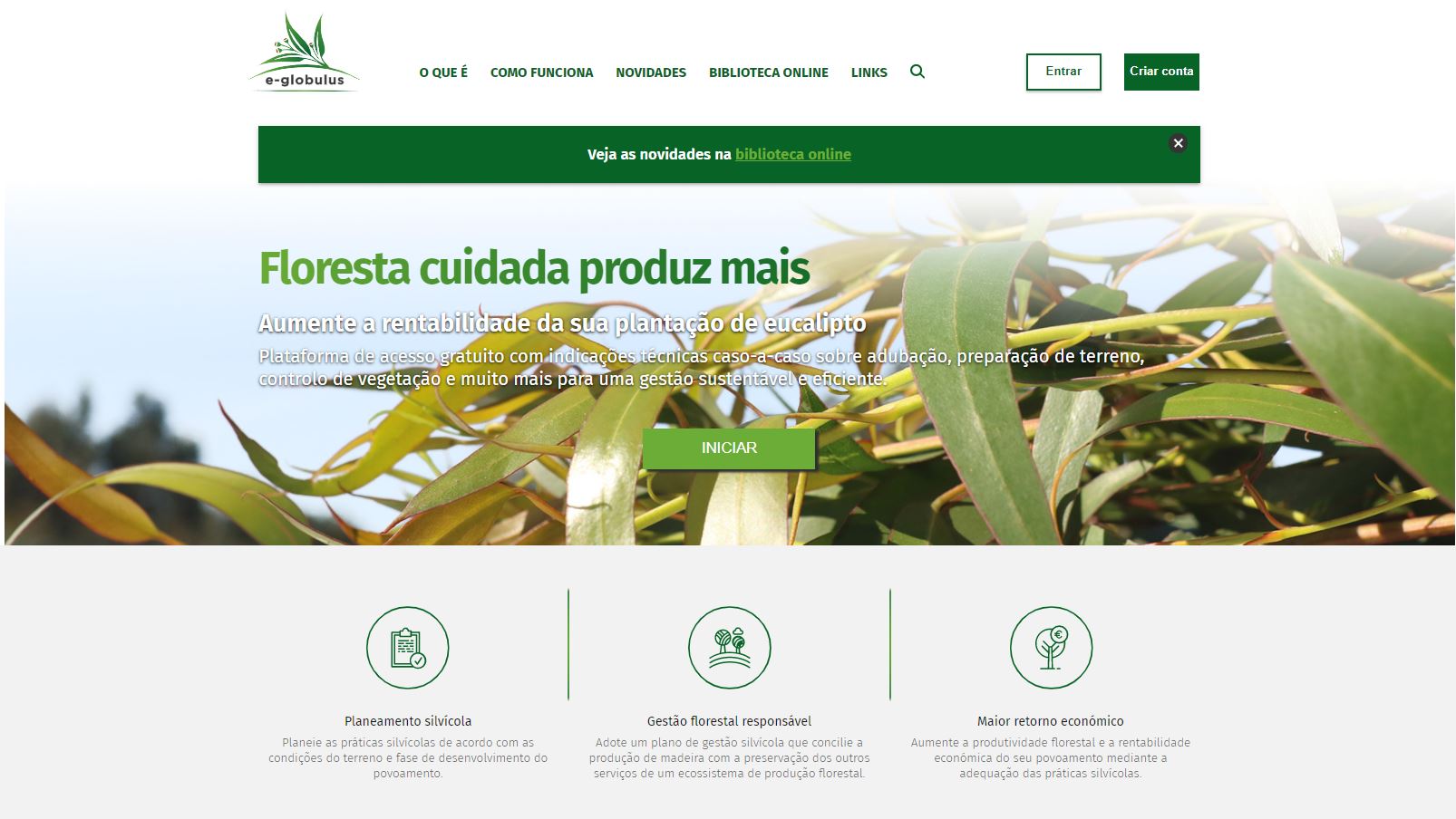
Potencjał dla mobilizacji drewna
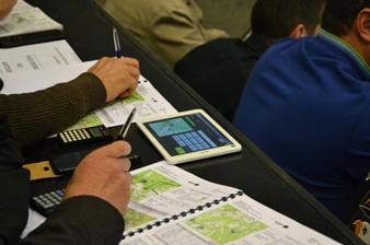
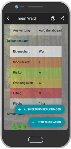
Hoch, Visualisierung und Spielcharakter der App helfen Waldbesitzern, forstwirtschaftliche Eingriffe besser einzuschätzen.
Potencjał dla zrównoważonego rozwoju
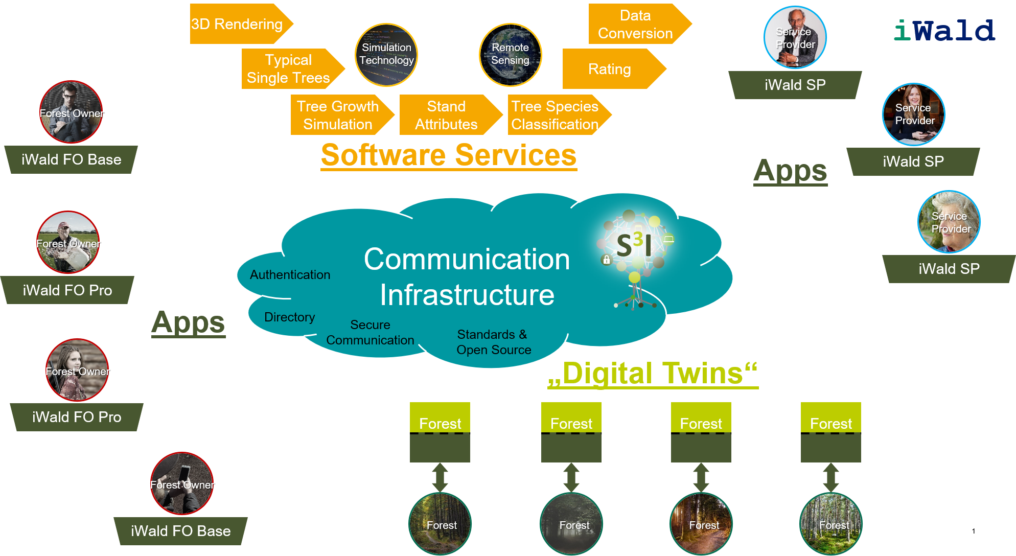
Nachhaltige Waldbewirtschaftung und individuelle Ziele der Waldbesitzer werden gleichermaßen berücksichtigt.
Wpływ na środowisko i bioróżnorodność

Ökonomische, ökologische und soziale Waldfunktionen sind in das Entscheidungsunterstützungssystem  integriert.

Łatwość wdrożenia
Die App ist noch nicht auf dem Markt verfügbar.
Voting
0%
Rok rozpoczęcia
2018
Rok zakończenia
2021
Tytuł (akronim)
iWald
Krótki opis
<table border="0" cellpadding="0" cellspacing="0" style="width:543px;" width="542"> <tbody> <tr height="60"> <td height="60" style="height:60px;width:543px;">Vergleich waldbaulicher Behandlungskonzepte durch Simulation von Wachstumsprozessen im Wald auf dem Smartphone</td> </tr> </tbody> </table>
Rozwiązanie cyfrowe
Yes
Abstrakt

Im Projekt iWald wird ein System entwickelt mit dem beispielsweise Waldbesitzer realitätsnahe und fachlich fundierte Handlungsoptionen zur nachhaltigen Bewirtschaftung ihrer Wälder erhalten. Hierbei werden sowohl die individuellen Zielsetzungen des Waldbesitzers (privat, kommunal, staatlich) berücksichtigt als auch die forstliche Risikominimierung und der zukunftsfähige Umbau von Wäldern unter Sicherung der ökonomischen, ökologischen und sozialen Waldfunktionen. Ein Hauptergebnis aus iWald wird die „iWald App“ sein mit Hilfe derer Wachstumsprozesse im Wald auf dem Smartphone simuliert werden können. Diese wird mit unterschiedlichen Einstiegshürden versehen sein, so findet sowohl der forstliche Laie als auch der ausgebildete Förster seinen Zugang zu iWald. Ziele sind unter anderem die Aktivierung von Waldbesitzern, die sich so auf spielerischem Niveau ihrem Wald nähern können oder die Verbesserung der öffentlichen Akzeptanz von forstlichen Eingriffen durch die Möglichkeit der einfachen Visualisierung zukünftiger Folgen.

Właściciel lub organizacja autorska
RWTH Aachen, Institute for Man-Machine Interaction
Właściciel lub twórca
Dr.Ing. Martin Hoppen
Organizacja reporterska
FBZ
Osoba przygotowująca fiszkę
Dr. Marie-Charlotte Hoffmann
Projekt
iWald, funded by FNR under no. 22012818
Zdjęcie główne
Logo dobrej praktyki
Logo organizacji
Dodatkowe materiały 1
BP - Rosewood - V1
NO
Potencjał dla zrównoważonego rozwoju - Wartość
Very Positive
Kraj pochodzenia
Niemcy
Tytuł (w języku narodowym)
iWald
Skala aplikacji
Projekt, w ramach którego stworzona została niniejsza fiszka
Posiada wideo
no