software di progettazione

Spagnolo
Innovazione
Yes
Source of wood

Above and below ground woody biomass

Proprietario o autore e-mail
Code
IN_ES_05
Time scale
From 2018
Tipo di legno in questione
Todo tipo de madera
potenziale sostenibilità
Muy positivo
Impatto sull'ambiente e la biodiversità

Positivo

Facilità di implementazione
Habilidades digitales sencillas y básicas
conoscenze specifiche necessarie
Muy altas capacidades y conocimientos en teledetección, selvicultura y desarrollo de software
I costi di attuazione

300.000-1.000.000 €  

Technical readiness level
Immediately applicable
prerequisiti chiave

Conocer su existencia

Location
Spain.
Implementers
Agresta S.Coop
Actual status
Running
Allegati
Country Region City
Spain
Scope
National
Voting
0%
Inizio anno
2018
Breve descrizione
ForestMap es una plataforma de comercio electrónico que permite a los usuarios realizar inventarios forestales fiables y en línea para un área específica de forma rápida y sencilla. Estima todas las variables relevantes incluidas en un inventario forestal profesional mediante la combinación de datos de teledetección preprocesados y potentes modelos predictivos.
Abstract

La interfaz intuitiva de ForestMap permite a cualquier persona generar automáticamente inventarios forestales de un área elegida sin necesidad de trabajo de campo ni retrasos innecesarios. ForestMap es una solución sin precedentes que ofrece informes de inventarios forestales precisos, rápidos y rentables.

Es necesario integrar un máximo de fuentes de información para generar inventarios lo más precisos, completos y actualizados posibles: LiDAR, satélite, fotogrametría, datos del terreno disponibles...
Las partes interesadas del sector forestal no están acostumbradas a trabajar con herramientas tecnológicas, por lo que es importante realizar una importante labor de demostración y apoyo.

ForestMap tiene un impacto positivo para una mayor movilización de los recursos madereros, permitiendo a los propietarios de los montes, a los operadores y a las industrias evaluar los rodales de una manera fácil y remota. ForestMap es capaz de proporcionar valiosos informes bajo demanda.
Una versión operativa de la plataforma web (enlace) está funcionando para 10 provincias en España, que cubre más de 3 M de hectáreas.
Los modelos de ForestMap han mostrado un alto rendimiento en términos de precisión (volumen BIAS< 20%) y tiempos de respuesta siendo capaces de producir un inventario completo de menos de 500 ha en minutos.
ForestMap se ha utilizado para producir productos a medida para usos y clientes específicos, basados en proyectos de innovación:
-Herramienta para calcular (enlace) la cantidad de carbono en las masas forestales de la provincia de Bizkaia (País Vasco, España).
-Herramienta de mapeo de inventario de modelos de combustible y para la prevención y gestión de incendios forestales en La Rioja.

Proprietario o organizzazione dell'autore
Agresta S. Coop.
Immagine principale
Logo delle migliori pratiche
Logo della principale organizzazione
Logo del progetto
Ulteriore visiva 1
Ulteriore visiva 2
Hub
South-Western Hub
BP - Rosewood - V1
YES
Paese d'origine
Spagna
Scala di applicazione
Progetto nell'ambito del quale questa scheda è stata creata
Ha un video
yes
Sloveno
Proprietario o autore e-mail
Voting
0%
Inizio anno
2000
Titolo (abbreviazione)
NGI
Breve descrizione
<table border="0" cellpadding="0" cellspacing="0" style="width:252px;" width="252"> <tbody> <tr height="60"> <td height="60" style="height:60px;width:252px;">Spremljanje stanja in razvoja slovenskih gozdov</td> </tr> </tbody> </table>
soluzione digitale
Yes
Tipo di soluzione
Abstract

V okviru nacionalne gozdne inventure (NGI) poteka monitoring in premerba slovenskih gozdov. V okviru NGI dobimo podatke o sestavi, stanju, razširjenosti in velikosti naših gozdov. Ti podatki so pomembni za spremljanje sprememb gozdov skozi čas, za razvoj ustreznih ukrepov politike in za nadaljnjo podporo trajnostnemu gospodarjenju z gozdovi. Osnovo za popis predstavlja sistematični vzorec ploskev na 4km x 4km mreži. Izbor popisnih ploskev poteka na podlagi uporabe lidarskih in letalskih posnetkov. Z njihovo pomočjo se izloči ploskve, ki niso locirane v gozdu, prav tako pa so v pomoč pri ocenjevanju gozdov na nedostopnih točkah. Pri terenskem popisu se uporablja za ta namen razvita aplikacija za zajem podatkov. Ta popisovalca vodi skozi postopek popisa, hkrati pa so podatki že digitalizirani in pripravljeni za nadaljno obdelavo. Aplikacija je povezana tudi z GPE napravo, ki omogoča natančno določitev vzorčne točke.

Proprietario o organizzazione dell'autore
Slovenian Forestry Institute
Nome del proprietario o dell'autore
Mitja Skudnik
Organizzazione di reporter
Slovenian Forestry Institute
E-mail del reporter
Progetto di riferimento
https://dirros.openscience.si/IzpisGradiva.php?id=14428
Immagine principale
Logo delle migliori pratiche
Logo della principale organizzazione
Ulteriore visiva 1
Ulteriore visiva 2
BP - Rosewood - V1
NO
Paese d'origine
Slovenia
Titolo (denominazione nazionale)
Nacionalna gozdna inventura
Scala di applicazione
Progetto nell'ambito del quale questa scheda è stata creata
Rosewood Video
Guarda il video
ROSEWOOD4.0 National Forest Inventory
Ha un video
yes
Inglese
Innovazione
Yes
Proprietario o autore e-mail
Voting
0%
Inizio anno
2000
Titolo (abbreviazione)
NFI
Breve descrizione
<table border="0" cellpadding="0" cellspacing="0" style="width:357px;" width="357"> <tbody> <tr height="60"> <td height="60" style="height:60px;width:357px;">Monitoring of state and development of Slovenian forests</td> </tr> </tbody> </table>
soluzione digitale
Yes
Tipo di soluzione
Abstract

Within National Forest Inventory (NFI) forests of Slovenia are monitored and measured. NFI provides extensive and in depth survey of all slovenia forests, including informations about composition, condition, distribution and size of our forests. It is of great importance for monitoring changes of forests through time, for developing suitable policy measures and for further support of sustainable management of forests. The basis for the inventory is a systematic sample of plots on a 4km x 4km grid. The selection of inventory plots is based on the use of lidar and aerial images. With their help, plots that are not located in the forest are eliminated, and they are also helpful in assesment of forests at inaccessible plots. A special data acquisition application was developed for the purpose of field inventory. This guides the enumerator through the inventory process, and at the same time the data is already digitized and ready for further processing. The application is also connected to a GPE device, which allows the precise determination of the sampling point.

Proprietario o organizzazione dell'autore
Slovenian Forestry Institute
Nome del proprietario o dell'autore
Mitja Skudnik
Organizzazione di reporter
Slovenian Forestry Institute
Nome del reporter
Polona Hafner
E-mail del reporter
Progetto di riferimento
https://dirros.openscience.si/IzpisGradiva.php?id=14428&lang=eng
Immagine principale
Didascalia dell'immagine principale
Sample plot grid of NFI Slovenia
Logo delle migliori pratiche
Logo della principale organizzazione
Ulteriore visiva 1
Ulteriore visiva 2
Hub
South-Eastern Hub
BP - Rosewood - V1
NO
Paese d'origine
Slovenia
Scala di applicazione
Progetto nell'ambito del quale questa scheda è stata creata
Rosewood Video
Guarda il video
ROSEWOOD4.0 National Forest Inventory
Ha un video
yes
Inglese
Innovazione
No
Source of wood

Stemwood; Above and below ground woody biomass

Proprietario o autore e-mail
Code
BP_FI_16
Time scale
From 2005
potenziale di mobilitazione
Not possible to assess.
Tipo di legno in questione
Stemwood; Above and below ground woody biomass (ex. shrubs, wood for fibres, wood for energy)
potenziale sostenibilità
Positive, a tool for more detailed planning of forest operations (timing, cutting amounts)
Impatto sull'ambiente e la biodiversità

Positive, versions of software for carbon sequestrion and economical impacts of protected forests are available

Facilità di implementazione
Easy
Impatto economico
Positive, helps in planning of forest operations
Effetto sul lavoro
Positive, helps in planning of forest operations
Effetto sul reddito
Not possible to assess.
conoscenze specifiche necessarie
Normal IT skills
I costi di attuazione

Open application

Technical readiness level
Immediately applicable
prerequisiti chiave

Application loadable on Luke web pages (Windows 7):
http://www.metla.fi/metinfo/motti/asennus.htm (Finnish version)
http://www.metla.fi/metinfo/motti/index-en.htm (English version)
New versions will be published in 2019 (Windows 10).

Location
Rovaniemi, Finland
Implementers
Forest owners, companies, authorities, research, education
Actual status
Running
Allegati
Country Region City
Finland
Scope
National
Voting
0%
Inizio anno
2005
soluzione digitale
Yes
Tipo di soluzione
Origine del legno
Tipo di legno
Abstract

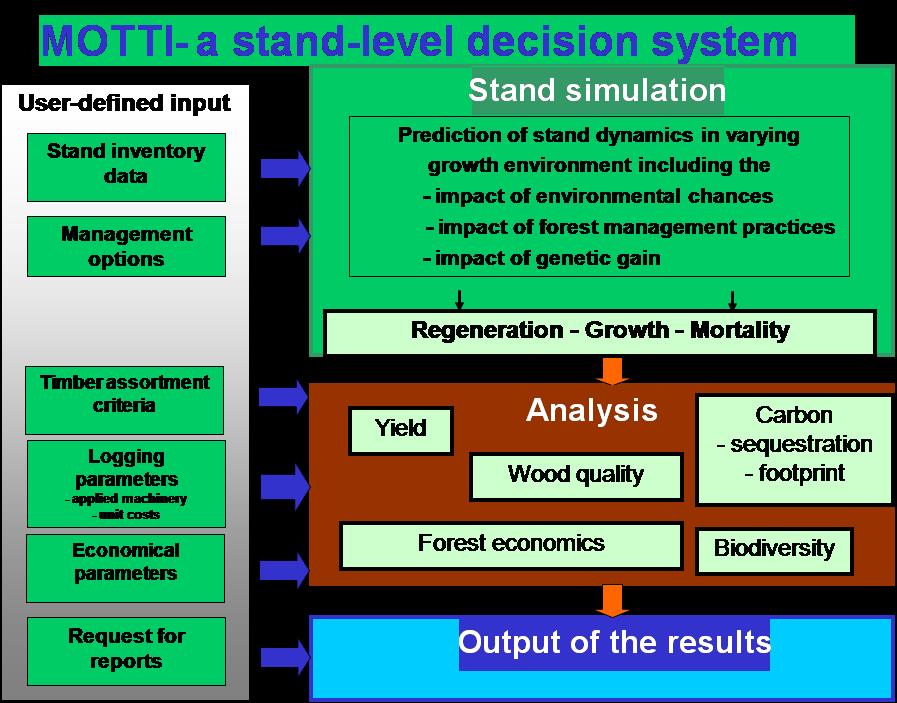
MOTTI is a stand-level analysis tool and decision support software by Luke. It contains the key results of the growth and yield research carried out by Luke, which can be used to predict the growth of forests managed using different techniques. The software also enables making comparisons between different silvicultural methods. MOTTI can also be used to investigate the effects of forest management or non-management, selection of tree species, regeneration chains or individual silvicultural measures, for example, on forest growth, harvesting volumes, profitability of forestry or the amount of carbon sequestered by forests.

MOTTI is widely used among professional foresters, forest owners, teachers, researchers, authorities and companies in Finland. It has been updated regularly with the newest growth models. It has also been tailored for special purposes, e.g. for teaching and for calculating economic effects of forest protection. It has been published in several languages (Finnish, Swedish, English, Russian) and it has also been piloted in other countries and tree species.

The core of MOTTI is a stand-level simulator, which includes growth and yield models for e.g. natural regeneration, growth and mortality. It is designed to simulate stand development under alternative management regimes and growth conditions in Finland.
MOTTI predicts the development of the user-defined initial stand until the end of the rotation. The user can define various management schedules including management practices, such as precommercial and commercial thinnings, fertilization, and ditch network maintenance in peatland forests. The user can adjust parameters such as timing and intensity of thinning and proportions of tree species, and define the timing of final cut. Timber assortments include logs, pulpwood and energy wood compartments. If the user do not define management practices, MOTTI simulates a default management program for the stand based on the current recommendations for forestry practice in Finland.
For the economic analysis (net present value and bare land value), the user can enter stumpage prices by tree species and timber assortments, costs (e.g. costs of first commercial thinnings, fertilisation and ditch network maintenance) and interest rate. The results will be presented in the form tables, graphs and files exportable to Excel.

Proprietario o organizzazione dell'autore
Natural Resources Institute Finland (Luke)
Immagine principale
Logo della principale organizzazione
Logo del progetto
Hub
Northern Hub
BP - Rosewood - V1
YES
Paese d'origine
Finlandia
Progetto nell'ambito del quale questa scheda è stata creata
Ha un video
yes