disturbi della foresta, i rischi, risposta ai disastri

Inglese
Innovazione
Yes
Proprietario o autore e-mail
Voting
0%
Titolo (abbreviazione)
FORCIP+
Breve descrizione
<table border="0" cellpadding="0" cellspacing="0" style="width:361px;" width="361"> <tbody> <tr height="95"> <td height="95" style="height:96px;width:361px;">The project aims at improving the use of the rural road network in case of emergency, especially forest fires. ​</td> </tr> </tbody> </table>
soluzione digitale
Yes
Tipo di soluzione
Abstract

Through transnational cooperation a wide range of inventories of existing road infrastructure will be accessible, ​ different requirements will be met and a ​ homogeneous model will be established. ​
ICT applications will be developed to improve the efficiency of use and​  propose improvements on the maintenance​
​Forest fire fighting vehicles will be equipped with GNSS receivers in order to improve time response and increase fuel savings.​
​Fire specialists will be able to use network analysis for resources planning, locating most suitable places for ground means waiting areas or identifying forest surfaces where takes longer to access. ​
​Other actors involved in emergencies will be able to use web management applications and public information.
Proprietario o organizzazione dell'autore
Laboratory of Photogrammetry and Remote Sensing, Aristotle University of Thessaloniki
Nome del proprietario o dell'autore
Petros Patias
Immagine principale
BP - Rosewood - V1
NO
Progetto nell'ambito del quale questa scheda è stata creata
Ha un video
no
Inglese
Innovazione
Yes
1 ° Dominio (principale)
Voting
0%
Titolo (abbreviazione)
GREEN FORESEEN
Breve descrizione
<table border="0" cellpadding="0" cellspacing="0" style="width:361px;" width="361"> <tbody> <tr height="95"> <td height="95" style="height:96px;width:361px;">Study the consumption of fuelwood by households in Greece<br /> and, by doing so, to lay down the foundations for the development of the first Greek Forest Sector Model (GFSM), which will<br /> be a partial-equilibrium model of the forest sector.&nbsp;</td> </tr> </tbody> </table>
soluzione digitale
Yes
Abstract

Design and carry out a
survey of the fuelwood market in Greece, as well as by analysing national statistics on energy consumption. This will give
insights on all aspects of fuelwood demand and supply and will allow for the characterisation of the illegal logging problem. It
will also assist in the development of the GFSM, as fuelwood constitutes over 65% of total timber production in the country.
The ultimate goal of the GFSM will be to enhance forest management by simulating impacts of policy and market changes
on the sector. An intentional byproduct of the GFSM will be the generation of knowledge that can be utilised by other
models, such as the EC's European Forest Information Scenario Model (EFISCEN).
Immagine principale
BP - Rosewood - V1
NO
Progetto nell'ambito del quale questa scheda è stata creata
Ha un video
no
Inglese
Innovazione
Yes
Proprietario o autore e-mail
Voting
0%
Breve descrizione
<table border="0" cellpadding="0" cellspacing="0" style="width:551px;" width="551"> <tbody> <tr height="60"> <td height="60" style="height:60px;width:551px;">Precision forestry service that with the help of RGB and multispectral images from drones, airplanes, helicopters or satellites can detect bark beetle infected or&nbsp;stressed trees.</td> </tr> </tbody> </table>
soluzione digitale
Yes
Abstract

Today, the technology for identifying bark beetle attacks in the forest is largely based on manual work through visual checks of forest areas, where early attacks are almost impossible to see, while old attacks are easier to detect. Attempts have been made to identify damage attacks using satellite radar maps which give a good indication and can be seen as a complementing part to our precision analysis. Arboair Forest Mapper is a service where you analyze your images via our AI. Our model is trained on over 200 000 trees and it is verified by forest managers.

Proprietario o organizzazione dell'autore
Paper Province
Nome del proprietario o dell'autore
Marcus Drugge
Organizzazione di reporter
Paper Province
Nome del reporter
Gunnar Hellerström
Immagine principale
Arboair forest aerial view
Logo della principale organizzazione
Arboair logo
BP - Rosewood - V1
NO
Paese d'origine
Svezia
Titolo (denominazione nazionale)
Arboair AB
Scala di applicazione
Progetto nell'ambito del quale questa scheda è stata creata
Rosewood Video
Ha un video
yes
Inglese
Innovazione
Yes
Proprietario o autore e-mail
Voting
0%
Breve descrizione
<table border="0" cellpadding="0" cellspacing="0" style="width:537px;" width="537"> <tbody> <tr height="60"> <td height="60" style="height:60px;width:537px;">Improvement of work safety through a new IT solution. A sensor node network connects to anyone involved (carrying such a node) and provides information about current danger situation over license-free band using Bluetooth low energy (BLE) .</td> </tr> </tbody> </table>
soluzione digitale
Yes
Abstract

Improved work safety through a sensor node network which connects to anyone carrying such a node and provides information about the current danger situation over a license-free band using Bluetooth low energy (BLE). For example: in a tree felling operation with a harvester which is supported by a forest worker, any person with such a little IT-device in his / her pocket (such as supervision personal, field forester, …) will get information about the position of the harvester and the work the harvester is doing. On the other hand, also the harvester has the information about these people. Risk alert warnings are sent to actors automatically, risk zones and risk status can be retrieved from actors, offenses of critical overlaps in risk safety zones are identified. The system is using u-Blox M8N GPS modules and map visualization on screens. The information gets translated to a danger situation depending on the individual work-situation (for example larger danger area when the harvester is cutting a tree than while driving). Communication of 150 - 700m, up to 9 slave nodes and battery allows 50h usage. GPS accuracy around 2.5m under forest conditions. The system may connect to a Cloud. This opens further data processing options, such as inclusion of passers-by via GSM-net or team-oriented data analysis for work-safety education needs. 

Proprietario o organizzazione dell'autore
BFH Bern University of Applied Sciences
Nome del proprietario o dell'autore
Martin Ziesak
Organizzazione di reporter
BFH Berne University of Applied Sciences
Nome del reporter
Moritz Dreher
E-mail del reporter
Immagine principale
Logo della principale organizzazione
Ulteriore visiva 1
Ulteriore visiva 2
BP - Rosewood - V1
NO
Paese d'origine
Svizzera
Titolo (denominazione nazionale)
Kollegenschutz4.0
Scala di applicazione
Progetto nell'ambito del quale questa scheda è stata creata
Ha un video
no
Inglese
Innovazione
Yes
Proprietario o autore e-mail
Voting
0%
Inizio anno
2018
fine anno
2021
Breve descrizione
Innovative R&amp;D project developing odor-based system (electronic nose) based on sensors with high sensitivity and AI to monitor selected, particularly dangerous forest pests.
soluzione digitale
Yes
Origine del legno
Abstract

The threat of forests by various harmful microorganisms is growing due to changing climate conditions and spreading of non-native pathogens and pests.. Simultaneously the relevance of biological methods of monitoring and preventing forest degradation is increasing in the face of the chemical’s use restrictions. The main aim of the project is the development of an innovative device (electronic nose/ e-NOS), based on a matrix of broad-band electrochemical sensors and neural networks that would detect and analyse the odor-based signals e.g. pheromones of certain insect species. The examples of pathogens and pests addressed in the project include Dendrolimus Pini (L.) and Phytophthora oomycetes.
The developed system delivers comprehensive and complex information which allows to create a neural classifier (using artificial intelligence). The dedicated software was developed to perform the analysis of the data and create a database – library of signals, which will allow to detect the analytes sought in the field. For each application foreseen in the project (analysis of specific smells), dedicated sensory matrices were prepared.   

Proprietario o organizzazione dell'autore
Warsaw University of Technology, Faculty of Physics
Nome del proprietario o dell'autore
Warsaw University of Technology, Faculty of Physics
Organizzazione di reporter
Łukasiewicz Research Network - Wood Technology Institute (ITD)
Nome del reporter
Dobrochna Augustyniak-Wysocka
Progetto di riferimento
Forecasting threats to forest ecosystems through the implementation of an innovative electronic system for the recognition of odors, co-financed by National Center for Research and Development (BIOSTRATEG III programme), 2018-2021, grant no. BIOSTRATEG3/347105/9/NCBR/2017
Immagine principale
Logo delle migliori pratiche
Hub
Central-East Hub
BP - Rosewood - V1
NO
Paese d'origine
Polonia
Titolo (denominazione nazionale)
Innowacyjny elektroniczny system rozpoznawania zapachów do prognozowania zagrożeń leśnych
Scala di applicazione
Progetto nell'ambito del quale questa scheda è stata creata
Ha un video
no
Spagnolo
Innovazione
Yes
Proprietario o autore e-mail
potenziale di mobilitazione
Uno de los casos desarrollados es CAMBRIC: orientado a simular la evolución de las masas forestales y la calidad de la madera en distintos escenarios de gestión forestal.
Tipo di legno in questione
Madera de masas forestales en riesgo de sufrir un incendio por alta concentración de material combustible, y masas forestales con desarrollo incierto que puede simular esta plataforma.
potenziale sostenibilità
Alta
Impatto sull'ambiente e la biodiversità

Muy alto ya que ayudará a proteger los bosques de los incendios para su mejor gestión.

Facilità di implementazione
“Consumir datos abiertos” no es fácil, por lo que resulta necesario crear eslabones intermedios y equipos multidisciplinares que permitan acercar las nuevas tecnologías a los usuarios, para poder diseñar soluciones útiles.
Impatto economico
Alto, dado que la información facilita la gestión y la previsión de los trabajos forestales que deben realizarse.
Effetto sul lavoro
El proyecto no tiene un efecto directo sobre el empleo, pero abre oportunidades para emprendedores y empresas, ya que la información publicada permite que cualquier usuario con el perfil adecuado pueda lanzar consultas y desarrollar herramientas adaptadas
Effetto sul reddito
No data
conoscenze specifiche necessarie
Medio, es necesario cierto conocimiento en el manejo de cartografía y herramientas forestales
I costi di attuazione

Presupuesto:
Total aceptado: 1.637.690 EUR
Contribución total del CEF: 1.228.268,00 (75% de los costes subvencionables)

prerequisiti chiave

La tecnología ya está desarrollada, los requisitos son similares a los necesarios para la utilización de cualquier otro software similar.

Voting
0%
Inizio anno
2018
fine anno
2021
Titolo (abbreviazione)
CROSS-FOREST
Breve descrizione
Cross-Forest tiene como objetivo publicar conjuntos de datos de inventarios forestales y mapas forestales de Portugal y España en formato Linked Open Data (LOD), y combinarlos para crear e integrar modelos que apoyen la gestión forestal y la protección de los bosques
soluzione digitale
Yes
Tipo di soluzione
Origine del legno
potenziale di sfruttamento

Los resultados obtenidos hasta ahora demuestran la utilidad y versatilidad que proporciona la tecnología LOD, ya que permite a los usuarios acceder y gestionar libremente datos actualizados para desarrollar herramientas adaptadas a sus necesidades y propósitos. 

La tecnología LOD permite ir construyendo de forma modular e interconectada una infraestructura de información abierta, pública y de calidad disponible para el sector. Dar continuidad a este tipo de publicación permite a las Administraciones Públicas cumplir con sus obligaciones de transparencia, optimizar recursos y llevar un control estadístico del uso que se hace de la información.


Abstract

Cross-Forest está desarrollando una plataforma común de datos forestales abiertos y un modelo de datos transfronterizo (ontología) compartido entre Portugal y España, para la publicación de inventarios forestales, mapas y otras bases de datos forestales en formato Linked Open Data (LOD). Cross-Forest proporcionará un repositorio público (endpoint) de publicación de Datos Forestales según el modelo producido. El objetivo principal se centra en mantener la información forestal siempre disponible y actualizada para facilitar su explotación a todos los agentes implicados en la gestión e investigación forestal.

Se están desarrollando dos casos de uso:
CAMBRIC - orientado a simular la evolución de las masas forestales y la calidad de la madera en distintos escenarios de gestión forestal.
FRAME – enfocado a la predicción del comportamiento y propagación de los incendios forestales a través de información precisa sobre materiales combustibles, mapas forestales y modelos de propagación.

Se emplean recursos de computación de alto rendimiento (HPC) debido a la cantidad de datos generados y gestionados, y a la complejidad de los modelos.

Los resultados obtenidos hasta ahora demuestran la utilidad y versatilidad que proporciona la tecnología LOD, ya que permite a los usuarios acceder y gestionar libremente datos actualizados para desarrollar herramientas adaptadas a sus necesidades y propósitos. La publicación de datos como LOD permite a las Administraciones Públicas cumplir fácilmente con sus requisitos de transparencia y publicidad, optimizar recursos y llevar un control estadístico del uso de los datos públicos.


Proprietario o organizzazione dell'autore
Grupo Tragsa
Nome del proprietario o dell'autore
Asunción Roldan Zamarrón
Organizzazione di reporter
Fundación Cesefor
Nome del reporter
Ángela García
E-mail del reporter
Progetto di riferimento
Cross-Forest está cofinanciado por la Agencia Ejecutiva de Innovación y Redes (INEA) de la Unión Europea, a través del Mecanismo Conectar Europa (CEF) 2014-2020. Acción 2017-EU-IA-0140 (Acuerdo nº INEA/CEF/ICT/A2017/1566738)
Immagine principale
Logo delle migliori pratiche
Logo della principale organizzazione
Logo del progetto
I costi di attuazione (Euro - €)
1.00 €
Facilità di implementazione - Valutazione
Very difficult
Hub
South-Western Hub
BP - Rosewood - V1
NO
potenziale sostenibilità - Valore
Very Positive
Paese d'origine
Spagna
Portogallo
Progetto nell'ambito del quale questa scheda è stata creata
Ha un video
no
Inglese
Innovazione
Yes
Proprietario o autore e-mail
potenziale di mobilitazione
Medium, this tool provides the best information for an appropiate managemnt to avoid forest fires and also for the best mangament, therfore, it will improve the mobilization potential when CrossForest is used for this purpose
Tipo di legno in questione
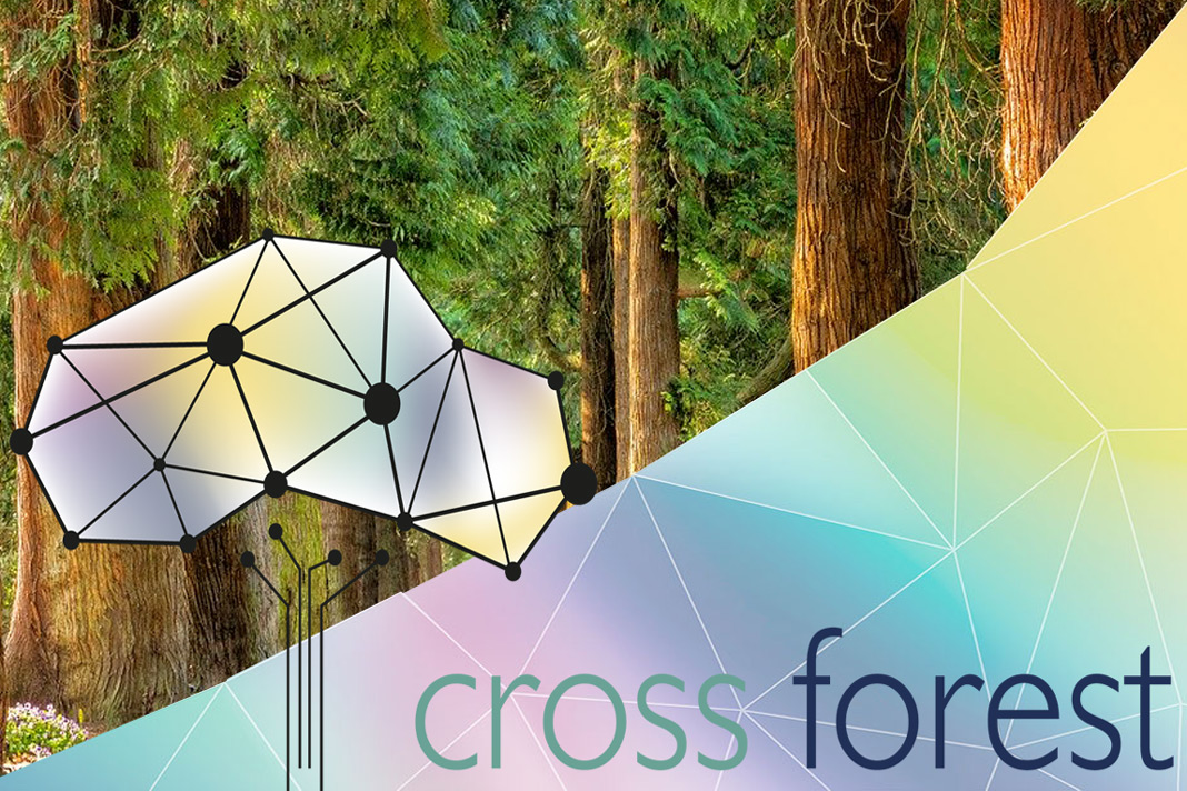
Mediterranean forests in Spain and Portugal
potenziale sostenibilità
Very high
Impatto sull'ambiente e la biodiversità

Very high as it will help to protect forests from fires for its best management.

Facilità di implementazione
"Consuming open data" is not easy, so it is necessary to create intermediate links and multidisciplinary teams to bring new technologies closer to users, in order to design adapted solutions.
Impatto economico
High, as the information facilitates the management and forecasting of forestry work to be carried out.
Effetto sul lavoro
The project does not have a direct effect on employment, but it opens up opportunities for entrepreneurs and companies, as the information published allows any user with the appropriate profile to launch queries and develop adapted tools.
Effetto sul reddito
No data
conoscenze specifiche necessarie
Medium, some knowledge of mapping and forestry tools is necessary.
I costi di attuazione

Budget:

Total accepted: 1.637.690 EUR

Total CEF contribution: 1.228.268,00 (75% eligible costs)

prerequisiti chiave

The technology is already developed, the requirements are similar to those necessary for the use of any other similar software.

Voting
0%
Inizio anno
2018
fine anno
2021
Titolo (abbreviazione)
CROSS-FOREST
Breve descrizione
The aim of Cross-Forest is to publish Forest Inventory Datasets and Forestry maps from Portugal and Spain in Linked Open Data (LOD) format, and to combine them to create and integrate models supporting forest management and forest protection.
soluzione digitale
Yes
Tipo di soluzione
Origine del legno
potenziale di sfruttamento

The results obtained so far demonstrate the usefulness and versatility provided by LOD technology, as it allows users to freely access and manage up-to-date data to develop tools adapted to their needs and purposes. 

LOD technology allows for the modular and interconnected construction of an open, public and quality information infrastructure available to the sector. The continuity of this type of publication allows public administrations to meet their transparency obligations, optimise resources and keep statistical control of the use made of the information.

Abstract

Cross-Forest is developing a common platform for open forest data, and a cross-border data model (ontology) shared between Portugal and Spain, for the publication of forest inventories, maps and other forest databases in Linked Open Data format (LOD). Cross-Forest will provide a public endpoint exposing Forest Data, according to the produced model. The main goal is focused on keeping forest information always available and updated, to make exploitation easier for all stakeholders involved in forest management and research.
Two use cases are being developed:
CAMBRIC - to estimate the evolution of forests and wood quality, under different management scenarios
FRAME - to predict forest fires behavior and spreading through precise information on combustible materials, forestry maps and propagation models.
High Performance Computing (HPC) resources are employed due to the amount of data generated and managed, and to the complexity of the models.
Results so far show the usefulness and versatility provided by LOD technology, as It allows users to freely access and manage updated data to develop tools adapted to their needs and purposes. Publishing data as LOD allows Public Administrations to easily fulfil their requirements of transparence and publicity, optimize resources and keep a statistic control of the use of public data.

Proprietario o organizzazione dell'autore
Grupo Tragsa
Nome del proprietario o dell'autore
Asunción Roldan Zamarrón
Organizzazione di reporter
Cesefor Foundation
Nome del reporter
Ángela García
E-mail del reporter
Progetto di riferimento
Cross-Forest is co-financed by the European Union’s Innovation and Networks Executive Agency (INEA), through the Connecting Europe Facility (CEF) 2014-2020. Action 2017-EU-IA-0140 (Agreement No INEA/CEF/ICT/A2017/1566738)
Immagine principale
Didascalia dell'immagine principale
Cross-Forest logo
Logo delle migliori pratiche
Logo della principale organizzazione
Logo del progetto
Hub
South-Western Hub
BP - Rosewood - V1
NO
potenziale sostenibilità - Valore
Very Positive
Paese d'origine
Portogallo
Spagna
Titolo (denominazione nazionale)
Armonización CROSS & modelización HPC de datos forestales
Progetto nell'ambito del quale questa scheda è stata creata
Ha un video
no
Inglese
Innovazione
Yes
Source of wood

Woodland/forests

Proprietario o autore e-mail
Code
IN_DE_05
Time scale
Since 2001
Id: 2861876
Continent Code: EU
Country Code: DE
Country Name: Germany
Name: North Rhine-Westphalia
Technical readiness level
Applicable
Location
NRW (Germany)
Implementers
RIF e.V.; RWTH Aachen (MMI); Lehrstuhl für Forstliche Arbeitswissenschaften und Angewandte Informatik & Lehrstuhl für Waldwachstumskunde (TU München); Institut für Roboterforschung (TU Dortmund); CPA-Systems GmbH und Pöyry Management Consulting (Deutschla
Actual status
Running
Country Region City
GermanyNordrhein-Westfalen
Scope
Regional
Voting
0%
Inizio anno
2001
soluzione digitale
Yes
Abstract

Applications like forest inventory and forestry planning, planning of fellings, optimization of harvesting and accounting processes, improvements of timber logistic, evaluation of damaging events etc. are expecting a realistic virtual illustration of the real forest. Within this project the preconditions for building up a single central database – the Virtual Forest - describing the extensive area of North Rhine-Westphalia are constructed. This database contains a mathematical description of biological and technical aspects of the real forest in different detailing (e.g. forest and single-tree consideration) and different precision. Apart from available terrestrial data and a digital site classification, developed by the Landesbetrieb Wald und Holz NRW, the Virtual Forest is based on remote sensing data and information derived thereof. It applies newly developed algorithms on well-known data formats: for single tree identification laser data and aerial images are used, tree species classification uses images and area segmentation is based on raster and vector data. Thus, a comprehensive survey ranging from inventory to forest growth to logistics can be provided. The Virtual Forest provides all stored data in a new 4D geo-data infrastructure while using standardised interfaces. All data (basic data, derived data, technical data, etc.) can also be used by third (programmes, users). Furthermore, a meta-data catalogue answers questions as “Which data of a certain area and/or to a specific subject are placed in which format, which exactness and which actuality at what costs at which place?” Appropriate safety concepts secure the data access as well as the data itself. The consequent consideration of the factor “time” transforms the 2D- or rather 3D- into a 4D-GIS based on a 4D geo-data infrastructure – the basis for a “time machine”. This enables the user to look at the forest at different (historical or future) conditions. The Virtual Forest serves as a foundation for abstracts of different economy units, which are from case to case both business and economically profitable, and with it for the management of larger amounts of wood at lower costs.

Proprietario o organizzazione dell'autore
RIF Institut für Forschung und Transfer e.V.
Organizzazione di reporter
InnovaWood asbl
Nome del reporter
Uwe Kies
E-mail del reporter
Risorsa 1 titolo
RWTH MMI project website / various demo videos
Immagine principale
Digital twin of forest as central service data platform for multiple forestry actors
Didascalia dell'immagine principale
Digital twin of forest as central service data platform for multiple forestry actors
Logo delle migliori pratiche
Logo della principale organizzazione
Logo del progetto
Ulteriore visiva 1
Ulteriore visiva 2
Ulteriore visiva 3
Regione di origine
2861876
BP - Rosewood - V1
YES
Paese d'origine
Germania
Scala di applicazione
Progetto nell'ambito del quale questa scheda è stata creata
Ha un video
yes
Inglese
Innovazione
No
Source of wood

Depending on user

Proprietario o autore e-mail
Code
BP_BW_12
Time scale
Development ongoing
potenziale di mobilitazione
High / app can be used anywhere in the forest
Tipo di legno in questione
Depending on user
potenziale sostenibilità
Positive
Impatto sull'ambiente e la biodiversità

Positive

Facilità di implementazione
Easy
Impatto economico
Positive / reduces workload for forest rangers
Effetto sul lavoro
N.A.
Effetto sul reddito
Positive
conoscenze specifiche necessarie
Dealing with smartphone
I costi di attuazione

N.A.

Technical readiness level
Applicable
prerequisiti chiave

Technological assistance
The app is available for free on Google Playstore

Location
Germany
Implementers
rBITech UG
Actual status
Completed, but continuously improved
Allegati
Country Region City
Germany
Scope
National
Voting
0%
soluzione digitale
Yes
Abstract

The ForestManager is an app that serves as a reminder in the management of forestland. Green areas and forests can be managed and documented with the support of GPS data. These functions offer the possibility to document observations, to take pictures, to print them, to send and to export them for further use. Moreover, it allows a comparison of historical and current data and can detect changes in the environment.

Technological assistance for the efficient management of forest areas.

Immagine principale
Logo della principale organizzazione
Logo del progetto
BP - Rosewood - V1
YES
Paese d'origine
Germania
Scala di applicazione
Progetto nell'ambito del quale questa scheda è stata creata
Ha un video
no
Inglese
Innovazione
Yes
Source of wood

Stemwood and woody biomass

Proprietario o autore e-mail
Code
IN_FR_03
Time scale
Since 2018
potenziale di mobilitazione
NA
Tipo di legno in questione
Woody biomass
potenziale sostenibilità
diagnostic tool that can be used throughout the country but must be tested in the field
Impatto sull'ambiente e la biodiversità

Limits the impact of slash harvesting on soil fertility in sensitive ares

Facilità di implementazione
Difficult: a lot of climate and soil data to integrate
Impatto economico
NA
Effetto sul lavoro
NA
Effetto sul reddito
NA
conoscenze specifiche necessarie
NA
I costi di attuazione

NA

Technical readiness level
Applicable in the next years
prerequisiti chiave

Association, organization of meeting days, responding to the NA

Location
France
Implementers
forest owners, forest manager, forest logger
Actual status
Closed
Allegati
Country Region City
France
Scope
National
Voting
0%
Inizio anno
2018
soluzione digitale
No
Origine del legno
Tipo di legno
Abstract

Easily assess the sensitivity of forest soil to increased biomass harvesting. The owner or manager must enter soil characteristics into the digital or paper application, which indicates the sensitivity level for several mineral elements.

This tool allows more intensive forest management to be applied in areas where the risk of soil depletion is low. It is necessary to train forest owners to describe soil horizons.

This tool is complementary to the ADEME's guide "sustainable forest slash harvesting" of 2006 which indicates how to describe the soil (type of humus, soil texture, pH,...) and gives management recommendations according to the different types of sensitivity.
This application takes into account the pedoclimatic zone, humus type, pH, soil texture and prospective depth. The soil is described 25 cm deep. The result of the analysis gives 3 sensitivity levels: low, medium or high applied generally to the soil or for each mineral element (calcium, magnesium, potassium, phosphorus, nitrogen).

Immagine principale
Logo del progetto
BP - Rosewood - V1
YES
Paese d'origine
Francia
Scala di applicazione
Progetto nell'ambito del quale questa scheda è stata creata
Ha un video
no