Plataformas de datos, centros de datos, datos abiertos

×

Mensaje de error

Notice: Undefined index: #markup in bootstrap_preprocess_field() (line 92 of /data/www/rosewood.admin.v4/sites/all/themes/bootstrap/template.php).
Inglés
Innovación
Yes
Source of wood

Stemwood, woody biomass, waste wood, 

Correo electrónico del autor o propietario
Código
IN_FR_05
Time scale
Since 2016
Potencial de movilización
NA
Tipo de madera afectada
Stemwood, woody biomass, waste
Potencial de sostenibilidad
evaluates the presence of stresses on the resource and avoids a boiler opening in this zone
Impacto en el medio ambiente y la biodiversidad

Little direct impact

Facilidad de aplicación
Difficult
Impacto económico
Platform used by public institutions or industries for decision support
Efecto sobre el empleo
Facilitates work to estimate boiler supply plans
Efecto sobre los ingresos
NA
Conocimientos específicos necesarios
Boiler consumption, resource availability data at a departmental level
Costes de aplicación

NA

Nivel de preparación técnica
Applicable in the next years
Prerequisitos clave

To have data on the different types of wood resources:stemwood, waste, related,...

Localidad
France
Implementers
for biomass cells in public institutions that allocate state subsidies each years for the creation of new biomass boilers
Actual status
Running
Adjuntos
País Región Población
France
Ámbito
National
Voting
0%
Año de comienzo
2016
Solución digital
Yes
Tipo de solución
Tipo de madera
Resumen

The project consists of creating a shared tool in the form of an online platform to facilitate the evaluation of supply plans and to limit conflicts of use from forest resources.
The tool integrates data related to the availability of the wood resource, taking into account harvests and past forest removals as well as the potential for additional wood energy and industrial wood harvesting. It thus provides an up-to-date view of the wood energy and wood industry resource at the departmental level.
In addition, the consumption of recent and planned biomass boiler is indicated in order to calculate the supply and demand balance for a territory.

Currently, the platform is tested and revised after feedback from users and experts associated with the project. It appears necessary to consolidate data on resource availability, biomass boiler consumption and other wood uses.

Data related to wood resources come from IGN inventories (National Institute for Geographic and Forestry Information), AGRESTE surveys (service of the Ministry of Agriculture and Food) and ADEME studies (Environment and Energy Management Agency).
With a single tool, it is possible to :
- monitor harvests and wood consumption at the departmental level,
- estimate the additional resource,
- use indicators of the capacity to mobilize the resource.
The platform provides summary tables on resource availability and a boiler consumption database. It allows users to monitor the evolution over time of biomass boiler and wood resource consumption.  
It also provides related indicators to estimate the strain on the resource. Users can simulate the impact of a new boiler installation on their territory.
This type of tool appears necessary and useful both for public bodies for the implementation of their policy, and for industrialists who wish to develop their activities.

Imagen principal
Logotipo del proyecto
Visual adicional 1
BP - Rosewood - V1
YES
País de origen
Francia
Escala de aplicación
Proyecto bajo el que se ha creado esta ficha
Tiene vídeo
no
Inglés
Innovación
Yes
Source of wood

Stemwood

Correo electrónico del autor o propietario
Código
IN_FR_02
Time scale
Since 2014
Potencial de movilización
Facilitates overall mobilization by reducing the administrative workload of contractors and improving the acceptability of forestry activity to elected officials, communities, etc.
Tipo de madera afectada
Stemwood
Potencial de sostenibilidad
a long-term project that develops step by step.
Impacto en el medio ambiente y la biodiversidad

No direct impact

Id: 11071620
Continent Code: EU
Country Code: FR
Country Name: France
Name: Nouvelle-Aquitaine
Facilidad de aplicación
Easy: mapping tool + database to create
Impacto económico
Reduces contractors' administrative time, freeing up time for prospecting
Efecto sobre el empleo
NA
Efecto sobre los ingresos
NA
Conocimientos específicos necesarios
NA
Costes de aplicación

150 000 €

Nivel de preparación técnica
Applicable
Prerequisitos clave

Tool for the entire forest-wood sector, facilitates exchanges and administrative procedures

Localidad
Nouvelle Aquitaine (France)
Implementers
loggers, companies in the sector, local elected officials
Actual status
running
Adjuntos
País Región Población
FranceNouvelle-Aquitaine
Ámbito
Regional
Voting
0%
Año de comienzo
2014
Solución digital
Yes
Tipo de solución
Origen de la madera
Tipo de madera
Resumen

FORETDATA is an operational collaborative platform for all stakeholders in the forest-wood-paper sector. It aims to improve knowledge of their activities by exchanging data. The platform makes it possible to obtain summaries at the level of the territory on the forest activity and to follow for each company their activities in relation to their data entry.
The mayors of municipalities can monitor the number of logging sites and their execution periods thanks to the platform.

The platform is developed only in New Aquitaine but it is possible to extend it to other regions. To function, it was necessary to establish a relationship of trust for rights management and application security.
The syntheses resulting from the platform are used as a means of communication with elected representatives in order to show the reality of forestry and to clarify the obstacles and their stakes.

Each forestry contractor fills in data related to the logging site (type of work, surface area, date of intervention, estimated volume, characteristics of the land) in order to fill out the online site opening declaration forms and safety data sheets. These are then sent directly to the services concerned (municipalities, DDT).
The sites are all mapped under GIS and the data referenced.
The users of the platform benefit:
- an online mapping tool that allows you to consult the cartographic bottoms and regulatory zoning
- of a drawing tool,
- of a shared directory,
- the production of standardised documents
- a platform for information exchange between companies.
In 2017, 182,000 ha were recorded on the platform, equivalent to 5,000 ha / month.
Currently, about twenty companies use the platform. The tool makes it possible to divide by 3 the time for a company to produce administrative documents.

Imagen principal
Logotipo del proyecto
Región de origen
11071620
BP - Rosewood - V1
YES
País de origen
Francia
Escala de aplicación
Proyecto bajo el que se ha creado esta ficha
Tiene vídeo
no
Inglés
Innovación
Yes
Source of wood

Stemwood

Correo electrónico del autor o propietario
Código
IN_FI_05
Time scale
Running
Potencial de movilización
Not possible to assess
Tipo de madera afectada
Stemwood
Potencial de sostenibilidad
Positive
Impacto en el medio ambiente y la biodiversidad

Positive/depends on management decisions

Facilidad de aplicación
Medium
Impacto económico
Positive
Efecto sobre el empleo
Less field work/ helps to plan forest operations
Efecto sobre los ingresos
Positive
Conocimientos específicos necesarios
IT-tool and silvicultural knowledge needed
Costes de aplicación

Monthly fee

Nivel de preparación técnica
Immediately applicable
Prerequisitos clave

Silviculture knowledge is needed

Localidad
Jyväskylä, Finland
Implementers
Forest service providers, Forest companies
Actual status
Running
Adjuntos
País Región Población
Finland
Ámbito
National
Voting
0%
Solución digital
Yes
Tipo de solución
Origen de la madera
Tipo de madera
Resumen

WoodsApp is a map based forest information system, where user can utilize search engine that enables finding ideal forest compartment according to user-specific requirements. All Finnish-wide open forest stand data by Finnish Forest Centre is available in the system. Service works effortlessly on both mobile device or tablet, when you are searching suitable wood trade and silvicultural work units. WoodsApp brings significant benefits for timber buyers, forest service providers and forest owners associations. The service is an effective tool for searching timber trade or silviculture targets, the new customer acquisition of the forest service business and the purchase of forest property. You can see area, main tree species, development class, cutting potential, action proposals and other information related to the forest stand. In addition to open forest stand data, useful background and theme maps are available. These maps help in finding important natural habitats or evaluate cutting potential.

Organización autora o propietaria de la buena práctica
Bitcomp Oy
Nombre del autor o propietario
Elina Koskimäki, Product Manager
Imagen principal
Logotipo del proyecto
Hub
Northern Hub
BP - Rosewood - V1
YES
País de origen
Finlandia
Escala de aplicación
Proyecto bajo el que se ha creado esta ficha
Tiene vídeo
yes
Inglés
Innovación
No
Source of wood

Stemwood; Above and below ground woody biomass

Correo electrónico del autor o propietario
Código
BP_FI_03
Time scale
From 2017
Potencial de movilización
Not possible to assess.
Tipo de madera afectada
Stemwood; Above and below ground woody biomass
Potencial de sostenibilidad
Positive, gives a picture of different kind of available biomasses and enhances sustainable use of natural resources
Impacto en el medio ambiente y la biodiversidad

Medium

Facilidad de aplicación
Medium, IT skills needed
Impacto económico
Positive, Atlas can be used in planning processes of different organizations including companies
Efecto sobre el empleo
Positive, Atlas can be used in planning processes of different organizations including companies
Efecto sobre los ingresos
Positive, Atlas can be used in planning processes of different organizations including companies
Conocimientos específicos necesarios
IT skills
Costes de aplicación

Open source

Nivel de preparación técnica
Immediately applicable
Prerequisitos clave

Web pages, see above.

Localidad
Kuopio, Finland (in the future also Sweden and Baltic sea countries)
Implementers
Companies, authorities, research, education
Actual status
Running
Adjuntos
País Región Población
Finland
Ámbito
National
Voting
0%
Año de comienzo
2017
Solución digital
Yes
Tipo de solución
Origen de la madera
Tipo de madera
Resumen

Biomass Atlas is an open service which collects the location data of biomasses under one, single user interphase. Developed by Luke together with Finnish organizations SYKE, TAPIO, UEF and UVA, and by the funding of the Finnish Ministry of Agriculture and Forestry, the service enables calculations of the amount of biomass in a given geographical area, as well as examining the opportunities and restrictions to utilise the biomass.
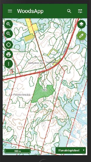
The map user interface is easy to use and allows user to watch, analyse and report biomasses from forestry, agriculture and biodegradable wastes from communities and industry. You will find approximately 300 map layers of different biomass types or land use categories in map user interface.

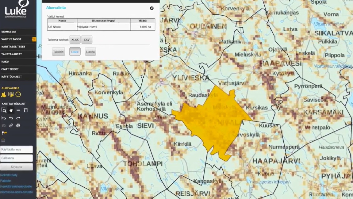
Based on Biomass Atlas, assessments of regional availability of biomass, procurement and logistical costs of biomass, procurement technology and optimization in Luke and other organizations have been successfully accomplished. Analyses of content of biomasses, their nutrients, energy potential, and the nutrient recycling have been optimized regionally using Biomass Atlas.
The potential to utilize biomass regionally can be assessed with focus in employment, regional economy or environmental impact. It is also possible to make scenarios, how these things will develop in the future.

The biomass data is planned to support investment decisions and sustainable use of natural resources, for example, and to help decision-makers to do sustainable energy politics. At the moment Biomass Atlas is available in Finnish. International version of Biomass Atlas will be built in cooperation with Baltic Forbio project, which starts at autumn 2017 and exports the Biomass Atlas concept to Sweden and Baltic sea countries. In Biomass Atlas you will find GIS data and maps of different biomass and land use types:

  • multisource national forest inventory data describes biomass that is growing in forests
  • forest chip potential
  • field and crop areas
  • crops and crop side streams
  • manure of production animals
  • biowaste from communities
  • biodegradable waste from companies in scale that requires environmental authorization (VAHTI-database).

Field area, crops and waste data is updated yearly. Manure data is updated when needed, and forest data approximately in every five years. All the data in Biomass Atlas is described also in Finnish metadataportal for geodata, Paikkatietohakemisto.

Organización autora o propietaria de la buena práctica
Natural Resources Institute Finland (Luke)
Nombre del autor o propietario
Eeva Lehtonen
Archivo - Recurso 1
Imagen principal
Logo de la Buena Práctica
Logotipo de la organización principal
Logotipo del proyecto
Hub
Northern Hub
BP - Rosewood - V1
YES
País de origen
Finlandia
Escala de aplicación
Proyecto bajo el que se ha creado esta ficha
Rosewood Video
Ver vídeo
Biomass Atlas (Finnish)
Tiene vídeo
yes